Łagów | |
|---|---|
Village | |
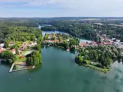
 Aerial view of Łagów | |
.svg.png.webp) Flag | |
| Motto(s): Perła Ziemi Lubuskiej Pearl of Lubusz Land | |
 Łagów | |
| Coordinates: 52°20′N 15°18′E / 52.333°N 15.300°E | |
| Country | |
| Voivodeship | Lubusz |
| County | Świebodzin |
| Gmina | Łagów |
| Established | 13th century |
| City rights | 1727-1932 |
| Population (2006) | |
| • Total | 1,600 |
| Time zone | UTC+1 (CET) |
| • Summer (DST) | UTC+2 (CEST) |
| Postal code | 66-220 |
| Area code | +48 68 |
| Car plates | FSW |
| Website | www.lagow.pl |
Łagów [ˈwaɡuf] is a village in Świebodzin County, Lubusz Voivodeship, in western Poland. It is the seat of the gmina (administrative district) called Gmina Łagów.[1] It lies approximately 19 kilometres (12 mi) north-west of Świebodzin, 45 km (28 mi) south of Gorzów Wielkopolski, and 46 km (29 mi) north of Zielona Góra. It is located in the historic Lubusz Land.
The oldest part of the village is situated on an isthmus between two lakes of the Łagowskie Lake District: Trześniowskie (186 ha) and Łagowski (82 ha). There is a Knights Hospitaller castle in Łagów, the Castle of the Order of St. John. The village gives its name to a protected area called Łagów Landscape Park.
Notable people
- Gerhard Domagk, German pathologist and bacteriologist, Nobel Prize laureate
References
Wikimedia Commons has media related to Łagów.
This article is issued from Wikipedia. The text is licensed under Creative Commons - Attribution - Sharealike. Additional terms may apply for the media files.
