| dystrykt niemetropolitalny | |
| Państwo | |
|---|---|
| Kraj | |
| Region | |
| Hrabstwo | |
| Siedziba | |
| Powierzchnia |
1085,9 km² |
| Populacja (2011) • liczba ludności |
|
| • gęstość |
87 os./km² |
| Plan | |
 | |
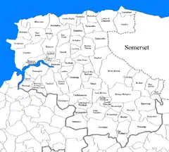
Położenie na mapie hrabstwa Devon | |
| Strona internetowa | |
Miasta
Inne miejscowości
Arlington, Ashford, Atherington, Baggy Point, Berrynarbor, Bishop’s Nympton, Bishop’s Tawton, Bittadon, Bratton Fleming, Braunton, Brayford, Brendon, Burrington, Challacombe, Chambercombe, Chelfham, Chittlehamholt, Chittlehampton, Churchill, Coleford, Combe Martin, Creacombe, Croyde, Countisbury, East and West Buckland, East Anstey, East Buckland, East Down, East Worlington, Filleigh, Fremington, Georgeham, George Nympton, Goodleigh, Heanton Punchardon, Horwood, Horwood, Lovacott and Newton Tracey, Instow, Kentisbury, King’s Nympton, Knowle, Knowstone, Landkey, Loxhore, Lee Bay, Lee, Lynmouth, Lynton i Lynmouth, Mariansleigh, Martinhoe, Marwood, Meshaw, Molland, Mortehoe, North Molton, Parracombe, Peters Marland, Pilton West, Putsborough, Queen’s Nympton, Rackenford, Romansleigh, Rose Ash, Satterleigh and Warkleigh, Saunton, Shirwell, Stoke Rivers, Swimbridge, Taddiport, Tawstock, Trentishoe, Twitchen, Umberleigh, West Anstey, West Buckland, West Down, Westleigh, Witheridge, Woolacombe, Wrafton, Yelland.