.jpeg.webp) Krajobraz Snowdonii | |||||
| |||||
| Państwo | |||||
|---|---|---|---|---|---|
| Księstwo | |||||
| Siedziba | |||||
| Powierzchnia |
1473 km² | ||||
| Populacja (2011) • liczba ludności |
| ||||
| • gęstość |
94 os./km² | ||||
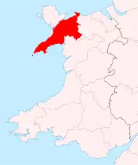
Położenie na mapie Walii | |||||
Caernarfonshire (Caernarvonshire, Carnarvonshire, wal. Sir Gaernarfon[1]) – hrabstwo historyczne w północno-zachodniej Walii (Wielka Brytania)[2].
Hrabstwo ustanowione zostało w 1284 roku na mocy statutu z Rhuddlan, który podporządkował Walię koronie angielskiej[2]. Jego stolicą było miasto Caernarfon[3]. Hrabstwo istniało do 1974 roku, kiedy to włączone zostało do nowo utworzonego hrabstwa Gwynedd[2]. Od 1996 roku najbardziej na wschód wysunięta część Caernarfonshire znajduje się w granicach hrabstwa Conwy[1].
Hrabstwo zajmowało powierzchnię 1473 km² (7,1% powierzchni Walii)[4]. W 1801 roku zamieszkane było przez 41 751 osób (6,9% całkowitej ludności Walii), w 1851 roku – 81 425 (6,8%)[5], w 1901 roku – 125 649 (6,2%)[6], a w 1951 roku – 124 140 (4,7%)[4]. W 2011 roku obszar dawnego hrabstwa zamieszkany był przez 139 065 osób[7]. W 1901 roku 89,6% mieszkańców potrafiło posługiwać się językiem walijskim, a dla 47,7% był to jedyny język. W 1991 roku znajomość tego języka deklarowało 61,5% mieszkańców[2].
Hrabstwo położone było nad wybrzeżem Morza Irlandzkiego, z linią brzegową o całkowitej długości nieco ponad 150 km. Zachodnia część hrabstwa znajdowała się na półwyspie Llŷn, oblewanym wodami zatok Cardigan i Caernarfon. Na północy cieśnina Menai Strait oddzielała hrabstwo od wyspy Anglesey. Wschodnią granicę hrabstwa wyznaczała rzeka Conwy[8]. W środkowej i wschodniej części hrabstwa znajdował się masyw górski Snowdonii, z najwyższym wzniesieniem Walii – górą Snowdon (1085 m n.p.m.)[7]. Od 1951 roku obszar ten objęty jest Parkiem Narodowym Snowdonia[9].
Tradycyjnym zajęciem miejscowej ludności jest wypas owiec. W XVIII i XIX wieku na wielką skalę prowadzone było wydobycie łupków. Współcześnie istotną rolę odgrywa turystyka, w szczególności piesza i wspinaczkowa[2]. Do tutejszych zabytków należą zamki w Caernarfon i Conwy[7].
Do głównych miejscowości hrabstwa należały: Bangor, Bethesda, Betws-y-Coed, Caernarfon, Conwy, Criccieth, Llandudno, Llanfairfechan, Penmaenmawr, Porthmadog oraz Pwllheli[7].
Przypisy
- 1 2 Caernarvonshire, [w:] Encyclopædia Britannica [dostęp 2023-10-01] (ang.).
- 1 2 3 4 5 John Cannon (red.): The Oxford Companion to British History. Oxford University Press, 2002, s. 151, 801. ISBN 978-0-19-860872-1. (ang.).
- ↑ Caernarfon, [w:] Encyclopædia Britannica [dostęp 2023-10-01] (ang.).
- 1 2 Census 1961: England and Wales: County Report: Cardiganshire and Pembrokeshire), Table 3: "Acreage, Population, Private Households and Dwellings for LAA, Wards, CP in RD, Con, NT". A vision of Britain through time. [dostęp 2023-10-01]. (ang.).
- ↑ 1851 Census of Great Britain, Population tables 2 (Sample Report Title: Population Tables I. Number of Inhabitants in the years 1801, 1811, 1821, 1831, 1841 and 1851: Report: Objects of census and machinery employed; results and observations; appendix of tabular results, and summary tables: England and Wales, Divisions I to VII. Area, houses, 1841 and 1851; Population, 1801, 1811, 1821, 1831, 1841, and 1851), Table [1: "Population Abstract".]. A vision of Britain through time. [dostęp 2023-10-01]. (ang.).
- ↑ 1911 Census of England and Wales, Census Returns of England and Wales, 1911, giving details of Areas, Houses, Families or separate occupiers, and Population:- Registration Areas, Table 5: "Registration Counties, Districts and Sub-districts with their constituent civil parishes. - Urban or Rural District in which each parish is situated; Area; families or separate occupiers, and population, 1901 and 1911; and population enumerated in Institutions, large establishments, and on vessels, &c., 1911".. A vision of Britain through time. [dostęp 2023-10-01]. (ang.).
- 1 2 3 4 Historic Counties Descriptions. The Historic Counties Trust. [dostęp 2023-10-01]. (ang.).
- ↑ Caernarvonshire. A vision of Britain through time. [dostęp 2023-10-01]. (ang.).
- ↑ A programme of exciting events to mark the Snowdonia National Park’s 70th Anniversary. Snowdonia National Park. [dostęp 2023-10-01]. (ang.).

