Upsal | |||||||||||||||||
|---|---|---|---|---|---|---|---|---|---|---|---|---|---|---|---|---|---|
 | |||||||||||||||||
| General information | |||||||||||||||||
| Location | 6460 Greene Street (Greene and Upsal Streets) Philadelphia, Pennsylvania | ||||||||||||||||
| Owned by | SEPTA | ||||||||||||||||
| Platforms | 2 side platforms | ||||||||||||||||
| Tracks | 2 | ||||||||||||||||
| Connections | |||||||||||||||||
| Construction | |||||||||||||||||
| Parking | 7 spaces | ||||||||||||||||
| Accessible | No | ||||||||||||||||
| Other information | |||||||||||||||||
| Fare zone | 2 | ||||||||||||||||
| History | |||||||||||||||||
| Electrified | March 22, 1918[1] | ||||||||||||||||
| Passengers | |||||||||||||||||
| 2017 | 356 boardings 305 alightings (weekday average)[2] | ||||||||||||||||
| Rank | 77 of 146 | ||||||||||||||||
| Services | |||||||||||||||||
| |||||||||||||||||
| |||||||||||||||||
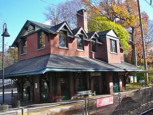
Upsal station is a SEPTA Regional Rail station in Philadelphia, Pennsylvania. Located at 6460 Greene Street, it serves the Chestnut Hill West Line.
The former station house, which was originally built by the Pennsylvania Railroad, was a café and restaurant in the 2010s.[3] The station is 9.1 track miles from Suburban Station. In 2017 it saw 356 boardings and 305 alightings on an average weekday.
Station layout
| P Platform level |
Side platform, doors will open on the right | |
| Outbound | ← Chestnut Hill West Line toward Chestnut Hill West (Carpenter) | |
| Inbound | Chestnut Hill West Line toward Temple University (Tulpehocken) → | |
| Side platform, doors will open on the right | ||
| G | Street level | Exit/entrance and parking |
References
- ↑ "Electric Train Has Trial Trip". The Harrisburg Telegraph. March 23, 1918. p. 10. Retrieved August 1, 2021 – via Newspapers.com.

- ↑ "Fiscal Year 2021 Service Plan Update". SEPTA. June 2020. p. 24. Retrieved March 11, 2022.
- ↑ "Existing Railroad Stations in Philadelphia County, Pennsylvania". Archived from the original on 2008-06-04. Retrieved 2008-08-15.
External links
- SEPTA - Upsal Station
- Old PRR Upsal Station images
- Greene Street entrance from Google Maps Street View
40°02′33″N 75°11′24″W / 40.0424°N 75.1900°W
This article is issued from Wikipedia. The text is licensed under Creative Commons - Attribution - Sharealike. Additional terms may apply for the media files.