Treutlen County | |
|---|---|
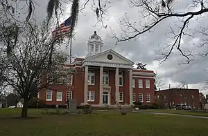
 Treutlen County Courthouse in Soperton | |
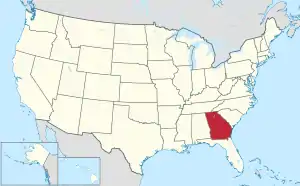
 Location within the U.S. state of Georgia | |
 Georgia's location within the U.S. | |
| Coordinates: 32°24′N 82°34′W / 32.4°N 82.57°W | |
| Country | |
| State | |
| Founded | November 5, 1918 |
| Named for | John A. Treutlen |
| Seat | Soperton |
| Largest city | Soperton |
| Area | |
| • Total | 202 sq mi (520 km2) |
| • Land | 199 sq mi (520 km2) |
| • Water | 3.0 sq mi (8 km2) 1.5% |
| Population (2020) | |
| • Total | 6,406 |
| • Density | 32/sq mi (12/km2) |
| Time zone | UTC−5 (Eastern) |
| • Summer (DST) | UTC−4 (EDT) |
| Congressional district | 12th |
| Website | Treutlen County, Georgia |
Treutlen County is a county located in the east central portion of the U.S. state of Georgia. As of the 2020 census, the population was 6,406.[1] The county seat is Soperton.[2] It is host to the Million Pines Arts and Crafts Festival which occurs during the first weekend in November.
History
The state constitutional amendment to create the county was proposed by the Georgia General Assembly on August 21, 1917, and ratified November 5, 1918. The county is named for John A. Treutlen,[3] Georgia's first state governor following adoption of the state Constitution of 1777.
Geography
According to the U.S. Census Bureau, the county has a total area of 202 square miles (520 km2), of which 199 square miles (520 km2) is land and 3.0 square miles (7.8 km2) (1.5%) is water.[4]
The western portion of Treutlen County, west of Soperton, is located in the Lower Oconee River sub-basin of the Altamaha River basin. The eastern portion of the county is located in the Ohoopee River sub-basin of the larger Altamaha River basin.[5]
Major highways
Adjacent counties
- Emanuel County (northeast)
- Montgomery County (southeast)
- Wheeler County (southwest)
- Laurens County (west)
- Johnson County (northwest)
Communities
Demographics
| Census | Pop. | Note | %± |
|---|---|---|---|
| 1920 | 7,664 | — | |
| 1930 | 7,488 | −2.3% | |
| 1940 | 7,632 | 1.9% | |
| 1950 | 6,522 | −14.5% | |
| 1960 | 5,874 | −9.9% | |
| 1970 | 5,647 | −3.9% | |
| 1980 | 6,087 | 7.8% | |
| 1990 | 5,994 | −1.5% | |
| 2000 | 6,854 | 14.3% | |
| 2010 | 6,885 | 0.5% | |
| 2020 | 6,406 | −7.0% | |
| U.S. Decennial Census[6] 1790-1880[7]1890-1910[8] 1920-1930[9] 1930-1940[10] 1940-1950[11] 1960-1980[12] 1980-2000[13] 2010[14] | |||
| Race | Num. | Perc. |
|---|---|---|
| White (non-Hispanic) | 4,065 | 63.46% |
| Black or African American (non-Hispanic) | 1,999 | 31.21% |
| Native American | 19 | 0.3% |
| Asian | 7 | 0.11% |
| Other/Mixed | 146 | 2.28% |
| Hispanic or Latino | 170 | 2.65% |
As of the 2020 United States census, there were 6,406 people, 2,490 households, and 1,654 families residing in the county.
Politics
| Year | Republican | Democratic | Third party | |||
|---|---|---|---|---|---|---|
| No. | % | No. | % | No. | % | |
| 2020 | 2,101 | 68.28% | 952 | 30.94% | 24 | 0.78% |
| 2016 | 1,809 | 66.93% | 862 | 31.89% | 32 | 1.18% |
| 2012 | 1,652 | 60.05% | 1,074 | 39.04% | 25 | 0.91% |
| 2008 | 1,826 | 61.65% | 1,112 | 37.54% | 24 | 0.81% |
| 2004 | 1,691 | 61.22% | 1,052 | 38.09% | 19 | 0.69% |
| 2000 | 1,062 | 54.10% | 879 | 44.78% | 22 | 1.12% |
| 1996 | 723 | 41.10% | 912 | 51.85% | 124 | 7.05% |
| 1992 | 898 | 38.31% | 1,116 | 47.61% | 330 | 14.08% |
| 1988 | 970 | 57.19% | 726 | 42.81% | 0 | 0.00% |
| 1984 | 1,086 | 56.30% | 843 | 43.70% | 0 | 0.00% |
| 1980 | 668 | 33.33% | 1,307 | 65.22% | 29 | 1.45% |
| 1976 | 465 | 22.88% | 1,567 | 77.12% | 0 | 0.00% |
| 1972 | 1,346 | 86.50% | 210 | 13.50% | 0 | 0.00% |
| 1968 | 474 | 25.00% | 341 | 17.99% | 1,081 | 57.01% |
| 1964 | 722 | 35.15% | 1,331 | 64.80% | 1 | 0.05% |
| 1960 | 216 | 18.90% | 927 | 81.10% | 0 | 0.00% |
| 1956 | 117 | 10.86% | 960 | 89.14% | 0 | 0.00% |
| 1952 | 101 | 6.66% | 1,416 | 93.34% | 0 | 0.00% |
| 1948 | 26 | 3.86% | 413 | 61.37% | 234 | 34.77% |
| 1944 | 34 | 3.67% | 893 | 96.33% | 0 | 0.00% |
| 1940 | 38 | 3.11% | 1,184 | 96.89% | 0 | 0.00% |
| 1936 | 23 | 2.46% | 912 | 97.44% | 1 | 0.11% |
| 1932 | 36 | 4.07% | 849 | 95.93% | 0 | 0.00% |
| 1928 | 64 | 14.04% | 392 | 85.96% | 0 | 0.00% |
| 1924 | 27 | 10.71% | 222 | 88.10% | 3 | 1.19% |
| 1920 | 107 | 28.92% | 263 | 71.08% | 0 | 0.00% |
See also
References
- ↑ "Census - Geography Profile: Treutlen County, Georgia". United States Census Bureau. Retrieved December 29, 2022.
- ↑ "Find a County". National Association of Counties. Retrieved June 7, 2011.
- ↑ Hellmann, Paul T. (May 13, 2013). Historical Gazetteer of the United States. Routledge. p. 246. ISBN 978-1135948597. Retrieved November 30, 2013.
- ↑ "US Gazetteer files: 2010, 2000, and 1990". United States Census Bureau. February 12, 2011. Retrieved April 23, 2011.
- ↑ "Georgia Soil and Water Conservation Commission Interactive Mapping Experience". Georgia Soil and Water Conservation Commission. Retrieved November 27, 2015.
- ↑ "Decennial Census of Population and Housing by Decades". US Census Bureau.
- ↑ "1880 Census Population by Counties 1790-1800" (PDF). US Census Bureau. 1880.
- ↑ "1910 Census of Population - Georgia" (PDF). US Census Bureau. 1910.
- ↑ "1930 Census of Population - Georgia" (PDF). US Census Bureau. 1930.
- ↑ "1940 Census of Population - Georgia" (PDF). US Census Bureau. 1940.
- ↑ "1950 Census of Population - Georgia -" (PDF). US Census Bureau. 1950.
- ↑ "1980 Census of Population - Number of Inhabitants - Georgia" (PDF). US Census Bureau. 1980.
- ↑ "2000 Census of Population - Population and Housing Unit Counts - Georgia" (PDF). US Census Bureau. 2000.
- ↑ "State & County QuickFacts". United States Census Bureau. Archived from the original on January 31, 2016. Retrieved June 26, 2014.
- ↑ "Explore Census Data". data.census.gov. Retrieved December 18, 2021.
- ↑ Leip, David. "Dave Leip's Atlas of U.S. Presidential Elections". uselectionatlas.org. Retrieved March 22, 2018.