Tayug | |
|---|---|
| Municipality of Tayug | |
 Tayug Welcome Arch | |
 Seal | |
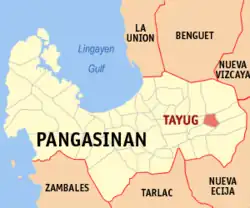
 Map of Pangasinan with Tayug highlighted | |
OpenStreetMap | |
.svg.png.webp) Tayug Location within the Philippines | |
| Coordinates: 16°01′36″N 120°44′52″E / 16.02667°N 120.74778°E | |
| Country | Philippines |
| Region | Ilocos Region |
| Province | Pangasinan |
| District | 6th district |
| Founded | March 17, 1817 |
| Barangays | 21 (see Barangays) |
| Government | |
| • Type | Sangguniang Bayan |
| • Mayor | Atty.Tyrone D.Agabas |
| • Vice Mayor | Lorna Primicias-Tacdol |
| • Representative | Marlyn Primicias Agabas |
| • Municipal Council | Members |
| • Electorate | 29,526 voters (2022) |
| Area | |
| • Total | 51.24 km2 (19.78 sq mi) |
| Elevation | 59 m (194 ft) |
| Highest elevation | 108 m (354 ft) |
| Lowest elevation | 43 m (141 ft) |
| Population (2020 census)[4] | |
| • Total | 45,241 |
| • Density | 880/km2 (2,300/sq mi) |
| • Households | 12,184 |
| Economy | |
| • Income class | 3rd municipal income class |
| • Poverty incidence | 8.07 |
| • Revenue | ₱ 183.3 million (2020) |
| • Assets | ₱ 257.2 million (2020) |
| • Expenditure | ₱ 153.9 million (2020) |
| • Liabilities | ₱ 40.65 million (2020) |
| Service provider | |
| • Electricity | Pangasinan 3 Electric Cooperative (PANELCO 3) |
| Time zone | UTC+8 (PST) |
| ZIP code | 2445 |
| PSGC | |
| IDD : area code | +63 (0)75 |
| Native languages | Pangasinan Ilocano Tagalog |
Tayug, officially the Municipality of Tayug (Pangasinan: Baley na Tayug; Ilocano: Ili ti Tayug; Tagalog: Bayan ng Tayug), is a 3rd class municipality in the province of Pangasinan, Philippines. According to the 2020 census, it has a population of 45,241 people.[4]
Etymology
The town of Tayug got its unique name not from people who were influential or from name of saints but from a very tall tree that once grew in the heart of the town; the bacayao tree was so tall that in Ilocano they call it “Tayag”. In view of the difficulty of the people to pronounce the letter “L” they change it to letter “T” by common usage. Hence, the name Tayug came about.
History
On June 22, 2003, Mayor Guerrero Zaragoza was assassinated by communist rebels from the New People's Army (NPA) as he was leaving a cockfighting arena at 2:45 a.m., with the cockpit's caretaker Wilfredo Hidalgo also gunned down.[6]
Geography
Barangays
Tayug is politically subdivided into 21 barangays. Each barangay consists of puroks and some have sitios.
- Agno
- Amistad
- Barangobong
- Carriedo
- C. Lichauco
- Evangelista
- Guzon
- Lawak
- Legaspi
- Libertad
- Magallanes
- Panganiban
- Brgy. Poblacion A
- Brgy. Poblacion B
- Brgy. Poblacion C
- Brgy. Poblacion D
- Saleng
- Santo Domingo
- Toketec
- Trenchera
- Zamora
Climate
| Climate data for Tayug, Pangasinan | |||||||||||||
|---|---|---|---|---|---|---|---|---|---|---|---|---|---|
| Month | Jan | Feb | Mar | Apr | May | Jun | Jul | Aug | Sep | Oct | Nov | Dec | Year |
| Mean daily maximum °C (°F) | 31 (88) |
31 (88) |
32 (90) |
34 (93) |
35 (95) |
34 (93) |
32 (90) |
32 (90) |
32 (90) |
32 (90) |
32 (90) |
31 (88) |
32 (90) |
| Mean daily minimum °C (°F) | 22 (72) |
22 (72) |
22 (72) |
24 (75) |
24 (75) |
24 (75) |
24 (75) |
24 (75) |
24 (75) |
23 (73) |
23 (73) |
22 (72) |
23 (74) |
| Average precipitation mm (inches) | 13.6 (0.54) |
10.4 (0.41) |
18.2 (0.72) |
15.7 (0.62) |
178.4 (7.02) |
227.9 (8.97) |
368 (14.5) |
306.6 (12.07) |
310.6 (12.23) |
215.7 (8.49) |
70.3 (2.77) |
31.1 (1.22) |
1,766.5 (69.56) |
| Average rainy days | 3 | 2 | 2 | 4 | 14 | 16 | 23 | 21 | 24 | 15 | 10 | 6 | 140 |
| Source: World Weather Online[7] | |||||||||||||
Demographics

| Year | Pop. | ±% p.a. |
|---|---|---|
| 1903 | 10,400 | — |
| 1918 | 13,594 | +1.80% |
| 1939 | 16,222 | +0.85% |
| 1948 | 19,782 | +2.23% |
| 1960 | 20,755 | +0.40% |
| 1970 | 24,143 | +1.52% |
| 1975 | 26,153 | +1.62% |
| 1980 | 26,273 | +0.09% |
| 1990 | 31,575 | +1.86% |
| 1995 | 33,881 | +1.33% |
| 2000 | 36,199 | +1.43% |
| 2007 | 37,954 | +0.66% |
| 2010 | 40,018 | +1.95% |
| 2015 | 43,149 | +1.45% |
| 2020 | 45,241 | +0.94% |
| Source: Philippine Statistics Authority[8][9][10][11] | ||
Economy
Government
Local government
Tayug, belonging to the sixth congressional district of the province of Pangasinan, is governed by a mayor designated as its local chief executive and by a municipal council as its legislative body in accordance with the Local Government Code. The mayor, vice mayor, and the councilors are elected directly by the people through an election which is being held every three years.
Elected officials
| Position | Name |
|---|---|
| Congressman | Tyrone D. Agabas |
| Mayor | Carlos Trece R. Mapili |
| Vice-Mayor | Lorna Primicias-Tacdol |
| Councilors | Edson M. Tandoc |
| Madilyn P. Cabotaje-Ramirez | |
| Romeo C. Vidal | |
| Jerry F. Adloc | |
| Roland B. Fonacier | |
| Clarissa L. Calimlim | |
| Mary P. Cabigas | |
| Al Godfred Gregor G. Allas | |
References
- ↑ Municipality of Tayug | (DILG)
- ↑ "2015 Census of Population, Report No. 3 – Population, Land Area, and Population Density" (PDF). Philippine Statistics Authority. Quezon City, Philippines. August 2016. ISSN 0117-1453. Archived (PDF) from the original on May 25, 2021. Retrieved July 16, 2021.
- ↑ Error: Unable to display the reference properly. See the documentation for details.
- 1 2 Census of Population (2020). "Region I (Ilocos Region)". Total Population by Province, City, Municipality and Barangay. Philippine Statistics Authority. Retrieved 8 July 2021.
- ↑ "PSA Releases the 2018 Municipal and City Level Poverty Estimates". Philippine Statistics Authority. 15 December 2021. Retrieved 22 January 2022.
- ↑ Sotelo-Fuertes, Yolanda (June 23, 2003). "Reds gun down Pangasinan mayor". Philippine Daily Inquirer. The Philippine Daily Inquirer, Inc. p. 1. Retrieved September 12, 2022.
- ↑ "Tayug, Pangasinan: Average Temperatures and Rainfall". World Weather Online. Retrieved 31 October 2015.
- ↑ Census of Population (2015). "Region I (Ilocos Region)". Total Population by Province, City, Municipality and Barangay. Philippine Statistics Authority. Retrieved 20 June 2016.
- ↑ Census of Population and Housing (2010). "Region I (Ilocos Region)" (PDF). Total Population by Province, City, Municipality and Barangay. National Statistics Office. Retrieved 29 June 2016.
- ↑ Censuses of Population (1903–2007). "Region I (Ilocos Region)". Table 1. Population Enumerated in Various Censuses by Province/Highly Urbanized City: 1903 to 2007. National Statistics Office.
{{cite encyclopedia}}: CS1 maint: numeric names: authors list (link) - ↑ "Province of Pangasinan". Municipality Population Data. Local Water Utilities Administration Research Division. Retrieved 17 December 2016.
- ↑ "Poverty incidence (PI):". Philippine Statistics Authority. Retrieved December 28, 2020.
- ↑ "Estimation of Local Poverty in the Philippines" (PDF). Philippine Statistics Authority. 29 November 2005.
- ↑ "2003 City and Municipal Level Poverty Estimates" (PDF). Philippine Statistics Authority. 23 March 2009.
- ↑ "City and Municipal Level Poverty Estimates; 2006 and 2009" (PDF). Philippine Statistics Authority. 3 August 2012.
- ↑ "2012 Municipal and City Level Poverty Estimates" (PDF). Philippine Statistics Authority. 31 May 2016.
- ↑ "Municipal and City Level Small Area Poverty Estimates; 2009, 2012 and 2015". Philippine Statistics Authority. 10 July 2019.
- ↑ "PSA Releases the 2018 Municipal and City Level Poverty Estimates". Philippine Statistics Authority. 15 December 2021. Retrieved 22 January 2022.
- ↑ "2019 National and Local Elections" (PDF). Commission on Elections. Retrieved March 7, 2022.