Taukum
Тауқұм | |
|---|---|
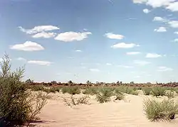
 View of the desert | |
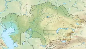
 Taukum Location in Kazakhstan | |
| Coordinates: 44°59′N 75°01′E / 44.983°N 75.017°E | |
| Location | Kazakhstan |
| Part of | Balkhash-Alakol Basin |
| Area | |
| • Total | ca 10,000 km2 (3,900 sq mi) |
| Dimensions | |
| • Length | 240 kilometers (150 mi) |
| • Width | 40 kilometers (25 mi) to 60 kilometers (37 mi) |
Taukum (Kazakh: Тауқұм) is a desert in the Almaty Region, Kazakhstan.[1][2]
Geography
Taukum is a sandy desert that is located in the southwestern part of the Balkhash-Alakol Basin. It extends to the south of the lower course of the Ili River, from the southern end of Lake Balkhash to the Bozoi Plateau. The Maizharylgan, part of the Chu-Ili Range rises to the west, and the Zhusandala Plain stretches to the south of the desert. Lake Itishpes lies at the northwestern end. The height of the sand dunes is between 10 meters (33 ft) and 15 meters (49 ft).[3]
Flora
The vegetation between sandy areas is made up of shrubs and grasses typical of arid zones, including sagebrush, saltwort, dzhuzgun, wormwood, saxaul and wheatgrass. There is a narrow stretch of riparian forest by the banks of the Ili river, at the northern limit of the desert.[3][4]
See also
References
- ↑ "L-43 Topographic Chart (in Russian)". Retrieved 1 October 2022.
- ↑ Google Earth
- 1 2 Таукум; Great Soviet Encyclopedia in 30 vols. — Ch. ed. A.M. Prokhorov. - 3rd ed. - M. Soviet Encyclopedia, 1969-1978. (in Russian)
- ↑ Kazakhstan National Encyclopedia. - Almaty: Kazakh encyclopedias, 2006. - T. V. -ISBN 9965-9908-5-9
External links
 Media related to Taukum at Wikimedia Commons
- Kazakhstan (2/6): Kolshengel, Taukum Desert & Topar Lakes