Sokh District
| |
|---|---|
| Sokh District | |
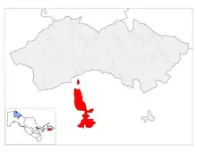
 Map showing the two exclaves in Kyrgyzstan that make up So'x in red | |
| Country | Uzbekistan |
| Region | Fergana Region |
| Capital | Ravon |
| Established | 1942 |
| Area | |
| • Total | 220 km2 (80 sq mi) |
| Population (2022) | |
| • Total | 80,600 |
| • Density | 370/km2 (950/sq mi) |
| Time zone | UTC+5 (UZT) |

Sokh District (Uzbek: Сўх тумани, romanized: Soʻx tumani, Tajik: ноҳияи Сӯх, romanized: Nohiyai Sūx, Russian: Сохский район, romanized: Sokhsky rayon) is a district of Uzbekistan's Fergana Region. It consists of two exclaves of Uzbekistan, surrounded by Kyrgyzstan. Despite being part of Uzbekistan, its population is almost entirely ethnic Tajiks, and the southern part of the district is closer to the border with Tajikistan than with the rest of Uzbekistan. Its capital is the town of Ravon.[1] It has an area of 220 km2 (85 sq mi)[2] and it has 80,600 inhabitants as of 2022.[3] The district consists of seven urban-type settlements (Ravon, Qalʻa, Sarikanda, Soʻx, Tul, Hushyor, Tarovatli) and four rural communities (Sohibkor, Ravon, Soʻx, Hushyor).[1] Another village in the district is Limbur.
Geography
The territory of Sokh is divided into two parts, separated by Kyrgyzstan:
- Soʻx (or Sokh or Southern Sokh or Upper Sokh), which is much more extensive than Northern Sokh. The area encompasses nineteen localities with an urban population of 65.9 percent and a rural population of 34.1 percent. It is 99 percent Tajik, 0.7 percent Kyrgyz and 0.3 percent Uzbek.
The exclave's name comes from the river Sokh, 124 km (77 mi) long, which crosses the territory and waters its fertile valley. The exclave is surrounded by the Kyrgyz Batken Region. Sokh's border is 135 km (84 mi) long, with nine border posts guarded by Kyrgyzstan.
- Chon Qora-Qalacha (or Chongara-Qalacha or Northern Sokh or Lower Sokh), comprising the villages of Chon-Qora (Chongara) and Qalacha.
Population
As of 2022, the population is 80,600.[3] Despite being a part of Uzbekistani territory and being surrounded by Kyrgyzstan, its population is mostly Tajik.[4]
History
.jpg.webp)
Together with Kokand, Sokh was one of the centres of the Basmachi uprising from 1918 to 1924. At that time, Sokh was still directly connected with Uzbekistan.[6]
Sokh was created in 1955. Local legend holds that “the territory was lost by a Kyrgyz Communist Party official in a card game with his Uzbek counterpart.” Others say it made sense to assign the area to Uzbekistan because the roads running along the Sokh river connected to Uzbekistan to the north rather than going through the rugged Kyrgyz territory to the east and west of the area in question.
In 1999, Uzbekistan claimed that militants from the Islamic Movement of Uzbekistan (IMU) were using Sokh as their base to attack Uzbekistan and Kyrgyzstan. Earlier that year, Tashkent had been rocked by a series of car bombings attributed to the IMU. Uzbekistan began mining the borders around Sokh, angering the Kyrgyz who claim Uzbekistan placed mines on its territory.[7]
Economy
The economy of Sokh is mainly based on agriculture (potatoes and fruits). The fields are supplied by the river Sokh so that agriculture is only possible in the valley plain. The Sokh valley forms a river oasis in the surrounding, barren grassland. The seasonal migration of the male labour force to Russia is also important. The exclave contains twenty-eight schools, two colleges, three clinics, twelve dispensaries and ten village health centres.
See also
- Sokh (river)
- Shohimardon, an Uzbekistan exclave in Kyrgyzstan
- Sarvan, a Tajikistan exclave in Uzbekistan
- Vorukh, a Tajikistan exclave in Kyrgyzstan
- Batken Region enclaves and exclaves
References
- 1 2 "Classification system of territorial units of the Republic of Uzbekistan" (in Uzbek and Russian). The State Committee of the Republic of Uzbekistan on statistics. July 2020.
- ↑ "O'zbekiston Respublikasining ma'muriy-hududiy bo'linishi" [Administrative-territorial division of the Republic of Uzbekistan] (PDF) (in Uzbek). Fergana regional department of statistics.
- 1 2 "Hududlar bo'yicha shahar va qishloq aholisi soni" [Urban and rural population by district] (PDF) (in Uzbek). Fergana regional department of statistics.
- ↑ "Convoluted borders are hampering Central Asian integration". The Economist. ISSN 0013-0613. Retrieved 2020-04-15.
- ↑ "Splendeurs des oasis dOuzbekistan, p.12" (PDF).
- ↑ "Ferghana Valley enclaves: a travel guide". Caravanistan. Retrieved 2020-04-15.
- ↑ Putz, Catherine. "More Trouble on the Kyrgyz-Uzbek Border". thediplomat.com. Retrieved 2020-04-15.
External links
- Kirgizia-Uzbekistan enclave Sokh (in Russian)
