Shayxontoxur | |
|---|---|
 | |
| Country | |
| Municipality | Tashkent |
| Established | 1981 |
| Area | |
| • Total | 29.7 km2 (11.5 sq mi) |
| Population (2021)[2] | |
| • Total | 348,300 |
| • Density | 12,000/km2 (30,000/sq mi) |
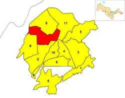
Shayxontoxur (Uzbek: Shayxontoxur tumani, Russian: Шайхантахурский район, romanized: Shaykhantakhursky rayon) is one of 12 districts (tuman) of Tashkent, the capital of Uzbekistan.[3]
Overview
It is a north-western district, established in 1981 with the name of Oktober,[4] referring to the October Revolution, part of Russian Revolution of 1917. It is the most densely populated tuman.
Shayxontoxur borders with the districts of Uchtepa, Chilanzar, Yakkasaray, Yunusabad and Olmazar. It borders also with Tashkent Region and is close to the Uzbek frontier with South Kazakhstan Region, in Kazakhstan.
Project
Famous buildings
| № | Name | Start of construction | End of construction | Buildings | Area (m²) | Notes |
|---|---|---|---|---|---|---|
| 1 | Gardens Residence | 2018 | 2020 | 9 | 89 518 | |
| 2 | Central Plaza | 2018 | 2021 | 6 | 45 886 | The first hotel in Uzbekistan under the Park Inn by Radisson brand |
| 3 | Hyper Partners Center | 2019 | 2021 | 4 | 76 744 | The largest shopping center in Uzbekistan |
| 4 | Nest One | 2019 | 2021 | 2 | 14 779 | Tallest residential building in Uzbekistan |
| 5 | Congress Hall, Hilton Hotel | 2018 | 2019 | 2 | 88 138 | The first hotel in Uzbekistan under the brand Hilton |
| 6 | Finance center | 2019 | 2021 | 5 | 44 235 | The largest financial center in Uzbekistan |
| 7 | Boulevard Residence | 2018 | 2020 | 9 | 116 761 | |
| 8 | Tashkent City Park | 2019 | 2019 | — | 186 804 | The largest recreational park area in Uzbekistan. The largest fountain in Uzbekistan. |
| 9 | U Tower | 2019 | 2023 | - | 187,160 | Offices, apartments, public spaces, restaurants and luxury shopping gallery. |
References
- ↑ "Districts". City of Tashkent. Retrieved 12 February 2022.
- ↑ "Urban and rural population by district" (PDF) (in Uzbek). Tashkent City department of statistics.
- ↑ "Classification system of territorial units of the Republic of Uzbekistan" (in Uzbek and Russian). The State Committee of the Republic of Uzbekistan on statistics. July 2020.
- ↑ Sadikov, A C; Akramob Z. M., Bazarbaev, A., Mirzlaev T.M., Adilov S. R., Baimukhamedov X. N., et al. (in Russian) (72x112). Geographical Atlas of Tashkent (Ташкент Географический Атлас) (2 ed.). Moscow. p. 64.
External links
![]() Media related to Districts of Tashkent at Wikimedia Commons
Media related to Districts of Tashkent at Wikimedia Commons
This article is issued from Wikipedia. The text is licensed under Creative Commons - Attribution - Sharealike. Additional terms may apply for the media files.