Shaoguan
韶关市 Shiukwan | |
|---|---|
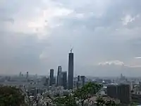
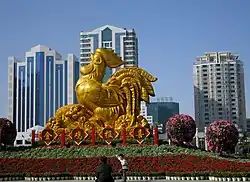
Left to right, top to bottom: Downtown Shaoguan from across the Bei River, street scene in central Shaoguan, Shaoyang Tower, the Pagoda of Sixi Temple, aerial view of the city | |
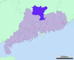
 Location of Shaoguan City jurisdiction in Guangdong | |
 Shaoguan Location in China | |
| Coordinates (Shaoguan municipal government): 24°48′40″N 113°35′49″E / 24.811°N 113.597°E | |
| Country | People's Republic of China |
| Province | Guangdong |
| County-level divisions | 10 |
| Municipal seat | Zhenjiang District |
| Government | |
| • CPC Secretary | Jiang Ling (江凌) |
| • Mayor | Luo Weifeng (骆蔚峰) |
| Area | |
| • Prefecture-level city | 18,645 km2 (7,199 sq mi) |
| • Urban | 2,870.7 km2 (1,108.4 sq mi) |
| • Metro | 2,870.7 km2 (1,108.4 sq mi) |
| Elevation | 59 m (194 ft) |
| Population (2020 census)[1] | |
| • Prefecture-level city | 2,855,131 |
| • Density | 150/km2 (400/sq mi) |
| • Urban | 1,028,460 |
| • Urban density | 360/km2 (930/sq mi) |
| • Metro | 1,028,460 |
| • Metro density | 360/km2 (930/sq mi) |
| Time zone | UTC+8 (China Standard) |
| Area code | (0)751 |
| ISO 3166 code | CN-GD-02 |
| Licence plate prefixes | 粤F |
| Local dialect | Hakka (regional) Cantonese (native; provincial level) |
| Major Nationalities | Han |
| Shaoguan | |||||||||||||||||||||||||||||
|---|---|---|---|---|---|---|---|---|---|---|---|---|---|---|---|---|---|---|---|---|---|---|---|---|---|---|---|---|---|
 "Shaoguan" in Traditional (top) and Simplified (bottom) Chinese characters | |||||||||||||||||||||||||||||
| Simplified Chinese | 韶关 | ||||||||||||||||||||||||||||
| Traditional Chinese | 韶關 | ||||||||||||||||||||||||||||
| Postal | Shiukwan Shiuchow (former) | ||||||||||||||||||||||||||||
| Literal meaning | Beautiful pass | ||||||||||||||||||||||||||||
| |||||||||||||||||||||||||||||
Shaoguan[lower-alpha 1] (Chinese: 韶关; Hakka: Seukoan) is a prefecture-level city in northern Guangdong Province (Yuebei), South China, bordering Hunan to the northwest and Jiangxi to the northeast. It is home to the mummified remains of the sixth Zen Buddhist patriarch Huineng. Its built-up (or metro) area made up of Zhenjiang, Wujiang and Qujiang urban conurbated districts was home to 1,028,460 inhabitants as of the 2020 census.[3]
History
Shaozhou was a prefecture under the Tang and Song.
In 1589, Matteo Ricci relocated his mission house – the first ever Jesuit mission in mainland China – to Shaoguan after a fallout with the authorities in Zhaoqing. He remained in Shaoguan for a few years, eventually benefiting from Shaoguan's location on the important north-south travel route to establish connections with traveling dignitaries that allowed him to move north, to Nanchang, Nanjing, and Beijing.[4]
During World War II the city, then called Kukong, was the temporary capital of Guangdong Province.
In June 2009, Uyghurs and Han workers clashed at a toy factory in Shaoguan (Shaoguan incident), which was followed by the Ürümqi riots in July.
Geography
.jpg.webp)
Shaoguan is the northernmost prefecture-level city of Guangdong, bordering Chenzhou (Hunan) to the northwest and north, Ganzhou (Jiangxi) to the northeast, Heyuan to the east, Guangzhou and Huizhou to the south, and Qingyuan to the west. It spans latitude 23° 05'−25° 31' N and longitude 112° 50'−114° 45' E. It is situated at the southern end of the Nan Mountains (Nan Ling), which primarily run east-west here, and is marked by numerous erosion-created valleys; within its borders lies the 1,902 m (6,240 ft) Mount Shikeng (石坑崆), the highest point in the province. The city is located on the Jingguang Railway (Beijing−Guangzhou) about 221 kilometres (137 mi) north of the provincial capital of Guangzhou. Shaoguan is also readily accessible by road as it is adjacent to the G4 Beijing–Hong Kong and Macau Expressway as well as numerous other National Highways.
At Shaoguan, the Wu River from the northwest and the Zhen River from the northeast join up to create the North River (Bei Jiang) which flows south to Guangzhou. The downtown part of Shaoguan is located on a peninsula between the Wu and Zhen Rivers. The rivers are maintained at a constant level by a dam about 12 kilometres (7.5 mi) downstream from the city. The city has about 20 kilometres (12 mi) of tree-lined riverside esplanades along the banks of the rivers. There are seven bridges crossing the three rivers.
Climate
Shaoguan has a monsoon-influenced humid subtropical climate (Köppen Cfa), with short, mild, damp winters, rainy springs, long, hot, and humid summers, and relatively sunny autumns. Due to the city's location far inland, winters are significantly cooler than in the rest of the province, with freezing rain possible in the nearby mountain passes in some years. Winter begins dry and relatively sunny but becomes progressively cloudier and damper. Spring is the cloudiest and wettest season, with the sun shining less than 30% of the time. The annual rainfall is around 1,600 mm (63 in), much of it delivered from April thru June. The monthly 24-hour average temperature ranges from 10.3 °C (50.5 °F) in January to 29.0 °C (84.2 °F) in July; the annual mean is 20.5 °C (68.9 °F). With monthly percent possible sunshine ranging from 16% in March to 54% in July, the city receives 1,617 hours of bright sunshine annually.
| Climate data for Shaoguan (1991–2020 normals, extremes 1971–2010) | |||||||||||||
|---|---|---|---|---|---|---|---|---|---|---|---|---|---|
| Month | Jan | Feb | Mar | Apr | May | Jun | Jul | Aug | Sep | Oct | Nov | Dec | Year |
| Record high °C (°F) | 27.7 (81.9) |
30.5 (86.9) |
32.6 (90.7) |
33.7 (92.7) |
36.4 (97.5) |
38.5 (101.3) |
40.4 (104.7) |
40.3 (104.5) |
38.3 (100.9) |
36.6 (97.9) |
34.0 (93.2) |
28.5 (83.3) |
40.4 (104.7) |
| Mean daily maximum °C (°F) | 14.9 (58.8) |
17.2 (63.0) |
19.7 (67.5) |
25.1 (77.2) |
29.0 (84.2) |
31.5 (88.7) |
33.8 (92.8) |
33.7 (92.7) |
31.4 (88.5) |
27.9 (82.2) |
22.8 (73.0) |
17.2 (63.0) |
25.3 (77.6) |
| Daily mean °C (°F) | 10.3 (50.5) |
12.7 (54.9) |
15.6 (60.1) |
20.9 (69.6) |
24.7 (76.5) |
27.3 (81.1) |
28.8 (83.8) |
28.4 (83.1) |
26.2 (79.2) |
22.2 (72.0) |
17.0 (62.6) |
11.7 (53.1) |
20.5 (68.9) |
| Mean daily minimum °C (°F) | 7.2 (45.0) |
9.6 (49.3) |
12.8 (55.0) |
17.8 (64.0) |
21.6 (70.9) |
24.4 (75.9) |
25.4 (77.7) |
24.9 (76.8) |
22.6 (72.7) |
18.1 (64.6) |
13.1 (55.6) |
8.0 (46.4) |
17.1 (62.8) |
| Record low °C (°F) | −2.5 (27.5) |
−1.4 (29.5) |
0.9 (33.6) |
5.7 (42.3) |
12.7 (54.9) |
16.6 (61.9) |
20.1 (68.2) |
20.1 (68.2) |
15.1 (59.2) |
6.3 (43.3) |
1.6 (34.9) |
−4.3 (24.3) |
−4.3 (24.3) |
| Average precipitation mm (inches) | 78.1 (3.07) |
88.9 (3.50) |
189.7 (7.47) |
207.1 (8.15) |
303.3 (11.94) |
288.5 (11.36) |
151.7 (5.97) |
144.1 (5.67) |
93.3 (3.67) |
46.2 (1.82) |
64.9 (2.56) |
56.9 (2.24) |
1,712.7 (67.42) |
| Average precipitation days (≥ 0.1 mm) | 10.9 | 12.1 | 18.6 | 17.0 | 18.3 | 18.7 | 14.1 | 14.0 | 10.3 | 5.9 | 7.6 | 7.8 | 155.3 |
| Average snowy days | 0.4 | 0.1 | 0 | 0 | 0 | 0 | 0 | 0 | 0 | 0 | 0 | 0.2 | 0.7 |
| Average relative humidity (%) | 77 | 78 | 82 | 81 | 81 | 81 | 77 | 78 | 78 | 73 | 75 | 74 | 78 |
| Mean monthly sunshine hours | 87.2 | 77.7 | 66.8 | 88.5 | 123.9 | 145.8 | 214.1 | 198.8 | 171.9 | 171.4 | 137.5 | 125.8 | 1,609.4 |
| Percent possible sunshine | 26 | 24 | 18 | 23 | 30 | 36 | 51 | 50 | 47 | 48 | 42 | 38 | 36 |
| Source 1: China Meteorological Administration[5][6] | |||||||||||||
| Source 2: Weather China[7] | |||||||||||||
Administrative divisions
Shaoguan has direct jurisdiction over 3 districts, 2 county-level cities and 5 counties:
| Map | Name | Simplified Chinese | Hanyu Pinyin | Population (2010 census) |
Area (km2) |
Density (/km2) | |||||
|---|---|---|---|---|---|---|---|---|---|---|---|
| Zhenjiang District | 浈江区 | Zhēnjiāng Qū | 393,521 | 572.11 | 688 | ||||||
| Wujiang District | 武江区 | Wǔjiāng Qū | 294,708 | 677.78 | 435 | ||||||
| Qujiang District | 曲江区 | Qǔjiāng Qū | 303,371 | 1,620.77 | 187 | ||||||
| Shixing County | 始兴县 | Shǐxīng Xiàn | 205,452 | 2,131.91 | 96 | ||||||
| Renhua County | 仁化县 | Rénhuà Xiàn | 200,354 | 2,223.22 | 99 | ||||||
| Wengyuan County | 翁源县 | Wēngyuán Xiàn | 331,120 | 2,174.87 | 152 | ||||||
| Xinfeng County | 新丰县 | Xīnfēng Xiàn | 206,091 | 1,967.39 | 105 | ||||||
| Ruyuan Yao Autonomous County | 乳源瑶族自治县 | Rǔyuán Yáozú Zìzhìxiàn | 177,471 | 2,299.01 | 77 | ||||||
| Lechang City | 乐昌市 | Lèchāng Shì | 397,779 | 2,419,28 | 164 | ||||||
| Nanxiong City | 南雄市 | Nánxióng Shì | 316,179 | 2,326,18 | 136 | ||||||
Tourism
The Fengcai Tower (simplified Chinese: 风采楼; traditional Chinese: 風采樓; pinyin: fēngcǎi lóu) in the centre of Shaoguan was built in the Ming Dynasty. To the south of the tower, at the other end of a pedestrian shopping street, the Dajian Monastery was founded in 660.
Near Shaoguan is the town of Maba, home of relics and museum of the Maba Man, Chinese Neanderthals. Near Maba is Nanhua Temple, which was founded by Huineng, the Sixth Patriarch of Zen Buddhism. Shaoguan Iron and Steel is also located near Maba.
Danxia Mountain is located in Renhua County, Shaoguan.
Northwest of Shaoguan, at the town of Pingshi, a stretch of river known as the Nine Torrents and Eighteen Shoals is a popular place for white-water rafting.
The city is served by Shaoguan Danxia Airport.
Education
Shaoguan University is located in the city.
Language
The main languages spoken are Hakka and Shaozhou Tuhua, related to Ping Chinese. Shaozhounese is spoken in Shaozhou city and Hakka (mainly Yetpet and Seunan dialects) are spoken in neighboring counties.
Notable people:
- Zhang, Jiu Ling (張九齡): a high ranking official of Tang Dynasty. (A.D. 618–A.D. 1127)
- Yu, Jing (余靖): a high ranking official of northern Song Dynasty. (A.D 960–A.D. 1127)
- Chu, Siu Hung (朱韶洪): Hong Kong social activist
- Regina Ho Yee Ting (何依婷): winner of 2017 Miss Hong Kong pageant, also an actress of Hong Kong
Gallery
 Zhongshan Park
 Central Shaoguan
 Guangdong Grand Canyon in Shaoguan
 Nanhua Temple
See also
Notes
- ↑ Alternative transliterations include Shiuchow (postal), Shiukwan (postal),[2] Shaokwan, Shao-chow, Xaocheu (Willem Blaeu's maps) and Chau Chew (Johan Nieuhof's illustration)
References
- ↑ Guăngdōng: Prefectures, Cities, Districts and Counties
- ↑ Theodore Shabad (1956). China's Changing Map: A Political and Economic Geography of the Chinese People's Republic. New York: Frederick A. Praeger. p. 166. LCCN 55-11530. OCLC 916993074.
With the exception of Shiukwan on the Canton-Hankow railroad, Kwangtung's regional centers are situated along the coast, notably in the Canton delta. There, in addition to Canton, are the cities of Fatshan, Kongmoon and Shekki. The metropolis of western Kwangtung is Tsamkong, and Pakhoi is the chief town of the western panhandle.
- ↑ "Search result of CHINA: Guăngdōng at citypopulation website".
- ↑ De Christiana expeditione apud Sinas
- ↑ 中国气象数据网 – WeatherBk Data (in Simplified Chinese). China Meteorological Administration. Retrieved 28 May 2023.
- ↑ 中国气象数据网 (in Simplified Chinese). China Meteorological Administration. Retrieved 28 May 2023.
- ↑ 韶关 - 气象数据 -中国天气网 (in Chinese). Weather China. Retrieved 27 November 2022.
External links
- http://www.shaoguan.gov.cn/ (in Chinese)
- https://web.archive.org/web/20040924085950/http://shaoguan.com.cn/ (in Chinese)
- Shaoguan, China


