Schierling | |
|---|---|
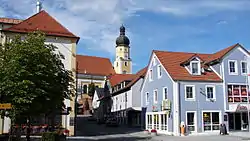
 Town square with the Church of Saints Peter and Paul | |
 Coat of arms | |
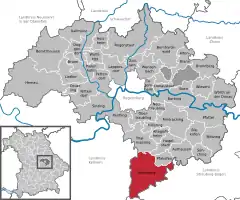
Location of Schierling within Regensburg district  | |
 Schierling  Schierling | |
| Coordinates: 48°50′05″N 12°08′23″E / 48.83472°N 12.13972°E | |
| Country | Germany |
| State | Bavaria |
| Admin. region | Oberpfalz |
| District | Regensburg |
| Subdivisions | 16 Ortsteile |
| Government | |
| • Mayor (2020–26) | Christian Kiendl[1] (CSU) |
| Area | |
| • Total | 77.62 km2 (29.97 sq mi) |
| Elevation | 381 m (1,250 ft) |
| Population (2022-12-31)[2] | |
| • Total | 8,488 |
| • Density | 110/km2 (280/sq mi) |
| Time zone | UTC+01:00 (CET) |
| • Summer (DST) | UTC+02:00 (CEST) |
| Postal codes | 84069 |
| Dialling codes | 09451 |
| Vehicle registration | R |
| Website | www.schierling.de |
Schierling is a municipality in the district of Regensburg in Bavaria, Germany.
The municipality is an important industrial location and the southernmost in the Upper Palatinate.
At the gates of Schierling, Napoleon and his allies defeated the Austrians in the Battle of Eckmühl. As early as the time of Otto the Great, he moved into his headquarters in Schierling during the siege of Regensburg on the Via Claudia Augusta, the road built by the Romans and named after their emperor Augustus.
References
- ↑ Liste der ersten Bürgermeister/Oberbürgermeister in kreisangehörigen Gemeinden, Bayerisches Landesamt für Statistik, 15 July 2021.
- ↑ Genesis Online-Datenbank des Bayerischen Landesamtes für Statistik Tabelle 12411-003r Fortschreibung des Bevölkerungsstandes: Gemeinden, Stichtag (Einwohnerzahlen auf Grundlage des Zensus 2011)
This article is issued from Wikipedia. The text is licensed under Creative Commons - Attribution - Sharealike. Additional terms may apply for the media files.