Suakin
سواكن Oosook | |
|---|---|
City | |
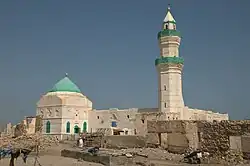
 Suakin, El-Geyf mosque | |
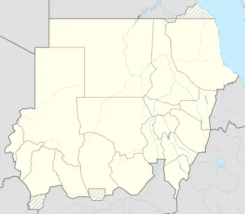
 Suakin Location in Sudan | |
| Coordinates: 19°06′09″N 37°19′48″E / 19.10250°N 37.33000°E | |
| Country | |
| District | Port Sudan |
| Population (2009 (est.)) | |
| • Total | 43,337 |
| Designations | |
|---|---|
| Official name | Suakin-Gulf of Agig |
| Designated | 2 February 2009 |
| Reference no. | 1860[1] |
Suakin or Sawakin (Arabic: سواكن, romanized: Sawākin, Beja: Oosook) is a port city in northeastern Sudan, on the west coast of the Red Sea. It was formerly the region's chief port, but is now secondary to Port Sudan, about 50 kilometres (30 mi) north.
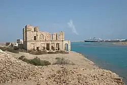
Suakin used to be considered the height of medieval luxury on the Red Sea, but the old city built of coral is now in ruins. In 1983, the adjacent historic mainland town, known as the Geyf, had a population of 18,030 and the 2009 population was estimated at 43,337.[2] Ferries run daily from Suakin to Jeddah in Saudi Arabia.
Etymology
The Beja name for Suakin is Oosook.[3] This is possibly from the Arabic word suq, meaning market. In Beja, the locative case for this is isukib, whence Suakin might have derived.[4] The spelling on Admiralty charts in the late 19th century was "Sauakin", but in the popular press "Suakim" was predominant.[5]
History
Ancient
Suakin was likely Ptolemy's Port of Good Hope, Limen Evangelis, which is similarly described as lying on a circular island at the end of a long inlet.[4] Under the Ptolemies and Romans, though, the Red Sea's major port was Berenice to the north. The growth of the Muslim caliphate shifted trade first to the Hijaz and then to the Persian Gulf.
Medieval
The collapse of the Abbasids and growth of Fatimid Egypt changed this and Al-Qusayr and Aydhab became important emporia, trading with India and ferrying African pilgrims to Mecca. Suakin was first mentioned by name in the 10th century by al-Hamdani, who says it was already an ancient town. At that time, Suakin was a small Beja settlement, but it began to expand after the abandonment of the port of Badi to its south. The Crusades and Mongol invasions drove more trade into the region: there are a number of references to Venetian merchants residing at Suakin and Massawa as early as the 14th century.

One of Suakin's rulers, Ala al-Din al-Asba'ani, angered the Mamluk sultan Baybars by seizing the goods of merchants who died at sea nearby. In 1264, the governor of Qus and his general Ikhmin Ala al-Din attacked with the support of Aydhab. Al-Asba'ani was forced to flee the city. The continuing enmity between the two towns is testified to by reports that after the destruction of Aydhab by Sultan Barsbay in 1426, the refugees, who fled to Suakin instead of Dongola, were all slaughtered.[6]
Despite the town's formal submission to the Mamluks in 1317, O. G. S. Crawford believed that the city remained a center of Christianity into the 13th century. Muslim immigrants such as the Banu Kanz gradually transformed this: Ibn Battuta records that in 1332, there was a Muslim "sultan" of Suakin, al-Sharif Zaid ibn-Abi Numayy ibn-'Ajlan, who was the son of a Meccan sharif. Following the region's inheritance laws, he had inherited the local leadership from his Bejan maternal uncles.[6] With the decline of Mamluk power in the late 14th century, the Hedareb tribe took over the port city and made it their capital. Suakin then established itself as the most important north east African port along the Red Sea.[7] In the fifteenth century, Suakin was briefly part of the Adal Sultanate.[8][9] Suakin was sieged by the Portuguese in 1513 and captured briefly in 1541.[10]
Ottoman

Following the Ottoman conquest of Egypt in 1517, the Ottoman Empire became the major power in the Red Sea. After a brief period of Ottoman-Portuguese struggles in the Red Sea, Özdemir Pasha occupied Suakin in the early 1550s. Though it was only loosely controlled, until the Ottoman province of Habesh was established in 1555 with the residence of its pasha in Suakin.[10] The Ottomans restored the two main mosques - Shafi'i and Hanafi, strengthened the walls of the fort and built new roads and buildings.[11][12][13] As the Portuguese explorers discovered and perfected the sea route around Africa and the Ottomans were unable to stop this trade, the local merchants began to abandon the town.[14]
Some trade was kept up with the Sultanate of Sennar, but by the 18th and 19th centuries, the Swiss traveler Johann Ludwig Burckhardt found two-thirds of the homes in ruins.[4] The Khedive Isma'il received Suakin from the Ottomans in 1865 and attempted to revitalize it: Egypt built new houses, mills, mosques, hospitals, and a church for immigrant Copts.
British rule
The British Army was involved at Suakin in 1883–1885 and Lord Kitchener was there in this period leading the Egyptian Army contingent. Suakin was his headquarters and his force survived a lengthy siege there.
The Australian colonial forces of Victoria offered their torpedo boat HMVS Childers and gunboats HMVS Victoria and HMVS Albert, which arrived in Suakin on 19 March 1884 on their delivery voyage from Britain, only to be released as fighting had moved inland. They departed on 23 March, arriving in Melbourne on 25 June 1884. An essentially civilian military force of 770 men from New South Wales, including some of the Naval Brigade, arrived in Suakin in March 1885 and served until mid-May.[15]
After the defeat of the Mahdist State, the British preferred to develop the new Port Sudan, rather than engage in the extensive rebuilding and expansion that would have been necessary to make Suakin comparable. By 1922, the last of the British had left.[4]

21st century
Since 2000, Sudan's National Corporation for Antiquities and Museums has undertaken research and documented the history of Suakin, and in 2022, the online project Sudan Memory published historical photographs, architectural drawings and a 3D reconstruction of the town on its website.[16]
On 17 January 2018, as part of a rapprochement with Sudan, Turkey was granted a 99-year lease over Suakin island.[17][18] Turkey plans to restore the ruined Ottoman port city on the island.[19]
Buildings of Suakin
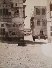
The buildings of Suakin were largely constructed of madrepore, or rock-coral, taken from the sea-bed. The vernacular style of construction under the Ottomans was akin to that of Jiddah in Arabia and Mitsiwa in Ethiopia. The houses, which had a white plaster finish, were up to four storeys in height and often built in blocks or terraces of three or more, separated by narrow streets. They had large casement windows (Arab. rushān) and doors of Java teak surmounted by carved stone door-hoods and denticulated parapets. From the 1860s an Egyptian style of architecture began to incorporate features from Egypt and Europe. As the buildings had no plaster covering, they decayed quickly and the town fell into ruin.
— Suakin, Grove Art Online [20]
A detailed description of the buildings of Suakin, including measured plans and detailed sketches, can be found in The Coral Buildings of Suakin: Islamic Architecture, Planning, Design and Domestic Arrangements in a Red Sea Port by Jean-Pierre Greenlaw, Kegan Paul International, 1995, ISBN 0-7103-0489-7.
Climate
Suakin has a very hot desert climate (Köppen BWh) with brutally hot and humid, though dry, summers and very warm winters. Rainfall is minimal except from October to December, when easterly winds can give occasional downpours: in November 1965 as much as 445 millimetres (17.5 in) fell, but in the whole year from July 1981 to June 1982 no more than 3 millimetres (0.1 in) was recorded.[21]
| Climate data for Suakin (Sawakin) | |||||||||||||
|---|---|---|---|---|---|---|---|---|---|---|---|---|---|
| Month | Jan | Feb | Mar | Apr | May | Jun | Jul | Aug | Sep | Oct | Nov | Dec | Year |
| Mean daily maximum °C (°F) | 26 (79) |
26 (79) |
27 (81) |
30 (86) |
33 (91) |
38 (100) |
42 (108) |
41 (106) |
37 (99) |
33 (91) |
30 (86) |
27 (81) |
32 (90) |
| Mean daily minimum °C (°F) | 19 (66) |
19 (66) |
20 (68) |
21 (70) |
24 (75) |
25 (77) |
28 (82) |
29 (84) |
26 (79) |
25 (77) |
23 (73) |
21 (70) |
23 (73) |
| Average rainfall mm (inches) | 8 (0.3) |
2 (0.1) |
1 (0.0) |
1 (0.0) |
1 (0.0) |
0 (0) |
8 (0.3) |
6 (0.2) |
0 (0) |
16 (0.6) |
54 (2.1) |
28 (1.1) |
125 (4.7) |
| Source: Weatherbase[22] | |||||||||||||
References
- ↑ "Suakin-Gulf of Agig". Ramsar Sites Information Service. Retrieved 25 April 2018.
- ↑ "World Gazeteer". Archived from the original on 19 September 2012.
- ↑ Wedekind, Klaus; Wedekind, Charlotte; Musa, Abuzeinab (2007). A Learner's Grammar of Beja (East Sudan). Köln: Rüdiger Köppe Verlag. p. 127. ISBN 9783896455727.
- 1 2 3 4 Berg, Robert: Suakin: Time and Tide Archived 2010-01-13 at the Wayback Machine. Saudi Aramco World.
- ↑ "Facts about Suakim". The South Australian Advertiser (Adelaide, SA : 1858 - 1889). Adelaide, SA: National Library of Australia. 23 April 1885. p. 6. Retrieved 10 January 2015.
- 1 2 Dahl, Gudrun & al: "Precolonial Beja: A Periphery at the Crossroads." Archived 2017-08-29 at the Wayback Machine Nordic Journal of African Studies 15(4): 473–498 (2006).
- ↑ Uhlig, Siegbert. Encyclopaedia Aethiopica - Volume 4 "Sawakin". p. 240.
- ↑ Owens, Travis. Beleaguered Muslim fortresses and Ethiopian imperial expansion from the 13th to the 16th century (PDF). Naval Postgraduate School. p. 23. Archived (PDF) from the original on November 12, 2020.
- ↑ Pouwels, Randall (31 March 2000). The History of Islam in Africa. Ohio University Press. p. 229. ISBN 9780821444610.
- 1 2 Peacock, A. C. S. (2012). "Suakin: A Northeast African Port in the Ottoman Empire". Northeast African Studies. 12 (1): 29–50. doi:10.1353/nas.2012.0009. ISSN 0740-9133. JSTOR 41960557. S2CID 143825903.
- ↑ Why is Sudan's Suakin island important for Turkey?
- ↑ Turks return to Suakin Island after two centuries
- ↑ Turkey renovating historic Ottoman-era sites on Suakin island in Sudan
- ↑ Uhlig, Siegbert. Encyclopaedia Aethiopica - Volume 4 "Sawakin". p. 240.
- ↑ Before the Anzac Dawn: A military history of Australia before 1915 Chapter 5: "Australian naval defence", Edited: Craig Stockings, John Connor (2013), accessed 23 June 2016
- ↑ "Suakin - Sudan Memory". www.sudanmemory.org. Retrieved 2022-04-11.
- ↑ "Suakin: 'Forgotten' Sudanese island becomes focus for Red Sea rivalries". Middle East Eye. Retrieved 31 March 2019.
- ↑ Lin, Christina. "Neo-Ottoman Turkey's 'String of Pearls'". Asia Times. Archived from the original on October 22, 2019.
The same year, Turkey signed trade and investment deals with Sudan, including to lease Suakin Island for 99 years as a possible military base. The island is located in the Red Sea close to Saudi Arabia and was once a key naval base of the Ottoman Empire.
- ↑ "Turkey to Restore Sudanese Red Sea Port and Build Naval Dock". Voice of America. 24 December 2017.
- ↑ . 2003. doi:10.1093/gao/9781884446054.article.T082150.
{{cite web}}: Missing or empty|title=(help); Missing or empty|url=(help) - ↑ Monthly rainfall for Suakin
- ↑ "Weatherbase: Historical Weather for Sawakin, Sudan". Weatherbase. 2011. Retrieved on November 24, 2011.
Further reading
- Greenlaw, Jean-Pierre (1995) The Coral Buildings of Suakin: Islamic Architecture, Planning, Design and Domestic Arrangements in a Red Sea Port. Kegan Paul International, ISBN 0-7103-0489-7
- Um, Nancy. "Greenlaw's Suakin: the limits of architectural representation and the continuing lives of buildings in Coastal Sudan." African Arts, vol. 44, no. 4, 2011, p. 36+. Gale Literature Resource Center
- Cooke, B. Kennedy, and B. Kennedy-Cooke. “The Red Sea coast in 1540.” Sudan Notes and Records, vol. 16, no. 2, 1933, pp. 151–59, JSTOR 41716059. Accessed 11 Apr. 2022.
- Livro de Lisuarte de Abreu: fac-simile. Comissão Nacional para as Comemorações dos Descobrimentos Portugueses. Lisboa, 1992. Vasco Graça Moura
- Couto, Diogo do; Observações sobre as principais causas da decadência dos portugueses na Ásia
External links
- Comparative Vocabularies of the Languages Spoken at Suakin: Arabic, Hadendoa, Beni-Amer
- Pictures of Suakin on Atlas Obscura
- Suakin: Time and Tide — on Saudi Aramco World
- Suakin Island - A Virtual Experience A 3D reconstruction of the Island
- https://observador.pt/2016/12/16/diogo-do-couto-o-portugues-da-india-ha-500-anos/