Sarjapura | |
|---|---|
Town | |
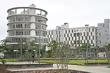
    (From top, L-R) Wipro Sarjapura campus, Kaikondrahalli lake on Sarjapura Road, An apartment complex off Sarjapura Road, Azim Premji University campus | |
 Sarjapura Location in Karnataka  Sarjapura Sarjapura (India) | |
| Coordinates: 12°51′36″N 77°47′10″E / 12.860°N 77.786°E | |
| Country | India |
| State | Karnataka |
| District | Bengaluru Urban |
| Metro | Bengaluru |
| Languages | |
| • Official | Kannada |
| Time zone | UTC+5:30 (IST) |
| Postal Index Number | 562125 |
| ISO 3166 code | IN-KA |
| Vehicle registration | KA |
| Website | karnataka |
Sarjapura is a small town situated in Bangalore, Karnataka, India. It is a hobli of Anekal taluk, Bangalore Urban district and is located towards the south-east of Bangalore. It is one of the industrial areas in Anekal taluk, with others being Attibele, Bommasandra, Chandapura, Electronic City and Jigani.
Demographics
As of 2001 India census, Sarjapura had a population of 8620, with 4370 males and 4250 females.[1][2]
References
- ↑ Village code= 2087400 "Census of India : Villages with population 5000 & above". Registrar General & Census Commissioner, India. Retrieved 18 December 2008.
- ↑ "Yahoomaps India :". Retrieved 18 December 2008. Sarjapura, Bangalore Urban, Karnataka
External links
- A history of Sarjapura Road: Citizen Matters
- When Sarjapur meant Muslin
- Popular lieutenant lends his name
- Sarjapur famous for Muslin and Silk
This article is issued from Wikipedia. The text is licensed under Creative Commons - Attribution - Sharealike. Additional terms may apply for the media files.