Saint-Louis-de-Gonzague | |
|---|---|
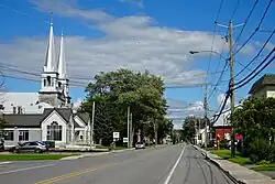
 Route 236 through St-Louis-de-Gonzague | |
_Quebec_location_diagram.PNG.webp) Location within Beauharnois-Salaberry RCM | |
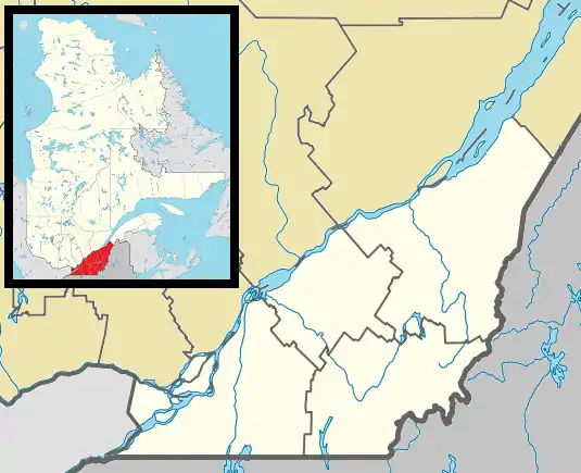
 St-Louis-de-Gonzague Location in southern Quebec | |
| Coordinates: 45°12′N 73°59′W / 45.2°N 73.98°W[1] | |
| Country | Canada |
| Province | Quebec |
| Region | Montérégie |
| RCM | Beauharnois-Salaberry |
| Constituted | July 1, 1855 |
| Government | |
| • Mayor | Yves Daoust |
| • Federal riding | Salaberry—Suroît |
| • Prov. riding | Beauharnois |
| Area | |
| • Total | 89.15 km2 (34.42 sq mi) |
| • Land | 77.04 km2 (29.75 sq mi) |
| Population (2021)[3] | |
| • Total | 1,950 |
| • Density | 25.3/km2 (66/sq mi) |
| • Pop (2016-21) | |
| • Dwellings | 777 |
| Time zone | UTC−5 (EST) |
| • Summer (DST) | UTC−4 (EDT) |
| Postal code(s) | |
| Area code(s) | 450 and 579 |
| Highways | |
| Website | sldg |
Saint-Louis-de-Gonzague is a parish municipality in the Beauharnois-Salaberry Regional County Municipality in the Montérégie region of Quebec, Canada. The population as of the 2021 Canadian census was 1,950.
The town centre is located along the banks of the Saint-Louis River.
History
One of the first settler in the area was Charles Larocque (1784-1849), who was deputy for Vaudreuil in the Legislative Assembly of Lower Canada from 1833 to 1838. He managed the first general store in the village, that was originally named after him: Rocqueville, or sometimes spelled Rocque-ville or Larocqueville. Other original settlers came mostly from Saint-Timothée, Les Cèdres, and Île Perrot in the middle of the 19th century.[1]
In 1845, the parish was formed, named after the Italian Jesuit Luigi Gonzaga. In 1855, the Parish Municipality of Saint-Louis-de-Gonzague was founded.[1]
Demographics
In the 2021 Census of Population conducted by Statistics Canada, Saint-Louis-de-Gonzague had a population of 1,950 living in 757 of its 777 total private dwellings, a change of 31.7% from its 2016 population of 1,481. With a land area of 77.04 km2 (29.75 sq mi), it had a population density of 25.3/km2 (65.6/sq mi) in 2021.[3]
| 2021 | 2016 | 2011 | |
|---|---|---|---|
| Population | 1,950 (+31.7% from 2016) | 1,481 (+6.6% from 2011) | 1,389 (-1.1% from 2006) |
| Land area | 77.04 km2 (29.75 sq mi) | 79.83 km2 (30.82 sq mi) | 79.42 km2 (30.66 sq mi) |
| Population density | 25.3/km2 (66/sq mi) | 18.6/km2 (48/sq mi) | 17.5/km2 (45/sq mi) |
| Median age | 36.0 (M: 36.4, F: 36.0) | 40.2 (M: 39.6, F: 40.6) | 39.6 (M: 39.2, F: 40.3) |
| Private dwellings | 777 (total) 757 (occupied) | 602 (total) | 548 (total) |
| Median household income | $87,000 | $73,557 | $64,906 |
|
|
| |||||||||||||||||||||||||||||||||||||||||||||||||||||||||||||||
| Source: Statistics Canada[9] | |||||||||||||||||||||||||||||||||||||||||||||||||||||||||||||||||
| Canada Census Mother Tongue - Saint-Louis-de-Gonzague, Montérégie, Quebec[9] | ||||||||||||||||||
|---|---|---|---|---|---|---|---|---|---|---|---|---|---|---|---|---|---|---|
| Census | Total | French |
English |
French & English |
Other | |||||||||||||
| Year | Responses | Count | Trend | Pop % | Count | Trend | Pop % | Count | Trend | Pop % | Count | Trend | Pop % | |||||
2021 |
1,950 |
1,850 | 94.9% | 55 | 2.8% | 35 | 1.8% | 15 | 0.8% | |||||||||
2016 |
1,480 |
1,425 | 96.3% | 35 | 2.4% | 10 | 0.7% | 5 | 0.3% | |||||||||
2011 |
1,390 |
1,340 | 96.4% | 35 | 2.5% | 10 | 0.7% | 5 | 0.4% | |||||||||
2006 |
1,385 |
1,265 | 91.3% | 20 | 1.4% | 25 | 1.8% | 75 | 5.4% | |||||||||
2001 |
1,355 |
1,305 | 96.3% | 30 | 2.2% | 10 | 0.7% | 10 | 0.7% | |||||||||
1996 |
1,395 |
1,350 | n/a | 96.8% | 35 | n/a | 2.5% | 10 | n/a | 0.7% | 0 | n/a | 0.0% | |||||
Local government

List of former mayors:[10]
- Jean François Gégoux (1856–1857)
- Charles Archambault (1857–1857)
- Jean Baptiste Bougie (1857–1868)
- Moïse Viau (1868–1872)
- Louis Pierre Coutlée (1872–1874)
- Joseph Bougie (1874–1875)
- Jean Baptiste Mire (1875–1886)
- Louis Bougie (1886–1888)
- Joseph Gagnier (1888–1891)
- Joseph Boyer (1891–1900)
- Hermène Payant (1900–1904)
- Louis Julien Pilon (1904–1906)
- Louis Billet (1906–1907)
- François Alfred Pilon (1907–1909)
- Abraham Jonathas Boyer (1909–1911)
- Charles Onésiphore Myre (1911–1912)
- Émérie Vinet (1912–1914)
- Louis Leduc (1914–1916)
- Louis Archambault (1916–1923)
- Joseph Jérôme Monpetit (1923–1931)
- Joseph Maheu (1931)
- Joachim Jean Baptiste Primeau (1931–1937)
- Joseph Dominat Daoust (1937–1951)
- Joseph Zénon Donat Meloche (1951–1961)
- Joseph Armand Ovila Houle (1961–1968)
- Joseph Arthur René Daoust (1968–1969)
- Joseph Zénon Oscar Billette (1969–1974)
- Joseph Gerard Marc-Hubert Pagé (1974–1978)
- Joseph Léo Victor Brault (1978–1983)
- Joseph-Augustin-Dominique Julien (1983–1989)
- Yves Daoust (1989–present)
See also
References
- 1 2 3 "Banque de noms de lieux du Québec: Reference number 57124". toponymie.gouv.qc.ca (in French). Commission de toponymie du Québec.
- 1 2 "Répertoire des municipalités: Saint-Louis-de-Gonzague". www.mamh.gouv.qc.ca (in French). Ministère des Affaires municipales et de l'Habitation. Retrieved 29 September 2023.
- 1 2 3 "Saint-Louis-de-Gonzague, Paroisse (municipalité de) (PE) Census Profile, 2021 Census of Population". www12.statcan.gc.ca. Government of Canada - Statistics Canada. Retrieved 29 September 2023.
- ↑ "2021 Community Profiles". 2021 Canadian Census. Statistics Canada. February 4, 2022. Retrieved 2022-08-23.
- ↑ "2016 Community Profiles". 2016 Canadian Census. Statistics Canada. August 12, 2021. Retrieved 2022-06-27.
- ↑ "2011 Community Profiles". 2011 Canadian Census. Statistics Canada. March 21, 2019. Retrieved 2014-02-15.
- ↑ "2006 Community Profiles". 2006 Canadian Census. Statistics Canada. August 20, 2019.
- ↑ "2001 Community Profiles". 2001 Canadian Census. Statistics Canada. July 18, 2021.
- 1 2 1996, 2001, 2006, 2011, 2016, 2021 census
- ↑ "Répertoire des entités géopolitiques: Saint-Louis-de-Gonzague (paroisse) 1.7.1855 - ..." www.mairesduquebec.com. Institut généalogique Drouin. Retrieved 28 September 2023.
External links
 Media related to Saint-Louis-de-Gonzague, Montérégie, Quebec at Wikimedia Commons