| Tensas River | |
|---|---|
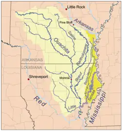
 Location of the Tensas River within the Tensas/Ouachita watershed. | |
| Physical characteristics | |
| Length | 250 mi (400 km) |
| Discharge | |
| • location | Tendall, LA (includes Bayou Macon) |
| • average | 1,205 cu/ft. per sec.[1] |
The Tensas River[2] /ˈtɛnsɔː/ is a river in Louisiana in the United States. The river, known as Tensas Bayou in its upper reaches,[3] begins in East Carroll Parish in the northeast corner of the state and runs roughly southwest for 177 miles (285 km)[4] more or less in parallel with the Mississippi River. The Tensas River merges with the Ouachita River in Jonesville in Catahoula Parish to become the Black River, not to be confused with Black Lake in Natchitoches Parish in north central Louisiana.
For the twenty miles south of Interstate 20 between Delhi and Tallulah, the river winds its way through the Tensas River National Wildlife Refuge (in Madison, Franklin, and Tensas parishes), which was established in 1980 "for the preservation and development of environmental resources" about the river. In 1881 the Congress authorized the U.S. Army Corps of Engineers to improve the navigation by removing ordinary obstacles.[5] The navigation work began at Dallas, a village on the stream in Madison Parish. The bottomland hardwood forest near the Tensas River is some of the remaining habitat of the Louisiana black bear.[6]
The name Tensas is derived from the historic indigenous Taensa people.[7] The first plantations along the Tensas River were established by settlers who had earlier plantations across the Mississippi River in the Natchez District.[8]

See also
References
- ↑ "USGS Surface Water data for Louisiana: USGS Surface-Water Annual Statistics".
- ↑ U.S. Geological Survey Geographic Names Information System: Tensas River
- ↑ U.S. Geological Survey Geographic Names Information System: Tensas Bayou
- ↑ U.S. Geological Survey. National Hydrography Dataset high-resolution flowline data. The National Map, accessed June 3, 2011
- ↑ Benyaurd, W. H. H. (1882). Annual report upon the preservation of the ports of Memphis, Vicksburg, and Natchez : improvement of the navigation of Red River, Louisiana and of certain rivers in Mississippi, Arkansas, and Tennessee; and water-gauges on the Mississippi and its principal tributaries, in charge of W. H. H. Benyaurd, being appendix P of the annual report of the Chief of Engineers for 1882.. Washington, D.C.: Government Printing Office., p. x.
- ↑ Benson, John F., and Michael J. Chamberlain. “Food Habits of Louisiana Black Bears (Ursus americanus luteolus) in Two Subpopulations of the Tensas River Basin.” The American Midland Naturalist, vol. 156, no. 1, University of Notre Dame, 2006, pp. 118–27, JSTOR website Retrieved 3 December 2021.
- ↑ Swanton, John Reed (1952). The Indian Tribes of North America. US Government Printing Office. p. 210. ISBN 978-0-8063-1730-4.
- ↑ Owens, Jeffrey Alan. “Naming the Plantation: An Analytical Survey from Tensas Parish, Louisiana.” Agricultural History, vol. 68, no. 4, Agricultural History Society, 1994, pp. 46–69, JSTOR website. Retrieved 3 December 2021.
- Tensas River National Wildlife Refuge, http://www.fws.gov/tensasriver/, Retrieved 23 April 2005
31°37′54″N 91°48′20″W / 31.63167°N 91.80556°W