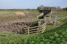

In parts of England and Wales, a rhyne (Somerset), rhine/rhyne (Gloucestershire), or reen (South Wales) (all pronounced /ˈriːn/ "reen"; from Old English ryne or Welsh rhewyn or rhewin "ditch") is a drainage ditch, or canal, used to turn areas of wetland close to sea level into useful pasture.
Water levels (and hence the level of the water table) will usually be controlled by a system of sluice gates and pumps, allowing the land to become wetter at times of the year when this will improve grass growth. Rhynes represent an early method of swamp or marsh drainage. Large sections of swampland were surrounded by trenches deep enough to drain the water from the encircled mound and leave the land relatively dry. Regular clearing and dredging is necessary to keep the rhynes clear of debris so that they flow freely.
Rhynes have been used extensively in the United Kingdom, especially on marshy coastal areas such as the Somerset Levels,[1] and the North Somerset Levels. Other examples in England exist in the Framilode and Saul area of Gloucestershire, where they drain into either the River Severn or Sharpness Canal, and the Pilning Levels alongside the Severn Estuary in South Gloucestershire between Avonmouth and Aust.[2] In southeast Wales, they can be found on the Caldicot and Wentloog Levels.[3][4] Many of them are still in use today.
Many rhynes in England and Wales are maintained as part of the water resource management operations of internal drainage boards. The rhynes near Wembdon village have some early references, including Fichet's rhyne in 1579 and the Great or Wildmarsh rhyne in 1705.[5]
The etymology of the name is unclear.[6] Some sources claim that rhyne is derived from the Irish word rathin, a diminutive of rath —a circular mound or entrenchment.[7] The word rhewyn is attested in Welsh from the 1400s onwards.[8]
Gallery

See also
References
- ↑ Havinden, Michael (1982). The Somerset Landscape. The making of the English landscape. Hodder and Stoughton. pp. 133–135. ISBN 0-340-20116-9.
- ↑ Landscape Character Assessment Area 20: Pilning Levels (PDF) (Report). South Gloucestershire Council. November 2014. Retrieved 27 December 2020.
- ↑ Geograph photos of Reens in the Levels, retrieved 5 May 2021
- ↑ BBC Newport Wetlands Reserve 18 February 2009 news.bbc.co.uk, retrieved 5 May 2021
- ↑ A P Baggs, M C Siraut (1992). R W Dunning, C R Elrington (ed.). "Wembdon". A History of the County of Somerset: Volume 6: Andersfield, Cannington, and North Petherton Hundreds (Bridgwater and neighbouring parishes). Institute of Historical Research. Retrieved 1 August 2011.
- ↑ "rhine, n.3". Oxford English Dictionary. Retrieved 27 December 2020.
- ↑ Gill, W. Walter (1929). A Manx Scrapbook. London & Bristol: Arrowsmith. Chapter IV: The Parish of German
- ↑ "Geiriadur Prifysgol Cymru".