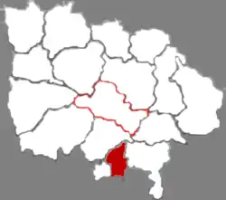
Quwo County
曲沃县 Kuwo; Küwo | |
|---|---|
 Quwo in Linfen | |
.png.webp) Linfen in Shanxi | |
| Coordinates (Quwo County government): 35°38′31″N 111°28′33″E / 35.6419°N 111.4758°E | |
| Country | People's Republic of China |
| Province | Shanxi |
| Prefecture-level city | Linfen |
| Area | |
| • Total | 437 km2 (169 sq mi) |
| Population (2013)[1] | |
| • Total | 230,000 |
| • Density | 530/km2 (1,400/sq mi) |
| Time zone | UTC+8 (China Standard) |
| Postal code | 043400 |
| Area code | 0357 |
Quwo County (Chinese: 曲沃县; pinyin: Qǔwò Xiàn) is a county under the administration of Linfen city, in southern Shanxi Province, China.[1] The county has spans an area of 437 square kilometers, and has a population of 230,000 as of 2013.[1]
History
From 745 to 677 BC Quwo was a state that broke off from the State of Jin. Quwo County was first set up in 487 CE under the Northern Wei Empire.[2] Since then, the county has not changed its name.[2]
Administrative divisions
Quwo County is divided into five towns and two townships: Lechang, Shicun, Qucun, Gaoxian, Licun, Beidong Township, and Yangtan Township.[1][3] The county's government is located within Lechang.[1]
Climate
| Climate data for Quwo (1991–2020 normals, extremes 1981–2010) | |||||||||||||
|---|---|---|---|---|---|---|---|---|---|---|---|---|---|
| Month | Jan | Feb | Mar | Apr | May | Jun | Jul | Aug | Sep | Oct | Nov | Dec | Year |
| Record high °C (°F) | 14.4 (57.9) |
23.0 (73.4) |
29.0 (84.2) |
36.1 (97.0) |
38.5 (101.3) |
41.3 (106.3) |
40.8 (105.4) |
38.6 (101.5) |
39.3 (102.7) |
31.5 (88.7) |
25.5 (77.9) |
16.7 (62.1) |
41.3 (106.3) |
| Mean daily maximum °C (°F) | 4.6 (40.3) |
9.3 (48.7) |
15.8 (60.4) |
22.6 (72.7) |
27.6 (81.7) |
32.0 (89.6) |
32.7 (90.9) |
30.8 (87.4) |
26.2 (79.2) |
20.0 (68.0) |
12.5 (54.5) |
5.8 (42.4) |
20.0 (68.0) |
| Daily mean °C (°F) | −2.1 (28.2) |
2.2 (36.0) |
8.6 (47.5) |
15.3 (59.5) |
20.5 (68.9) |
25.1 (77.2) |
26.8 (80.2) |
25.0 (77.0) |
20.0 (68.0) |
13.4 (56.1) |
5.8 (42.4) |
−0.7 (30.7) |
13.3 (56.0) |
| Mean daily minimum °C (°F) | −7.1 (19.2) |
−3.1 (26.4) |
2.4 (36.3) |
8.4 (47.1) |
13.5 (56.3) |
18.6 (65.5) |
21.5 (70.7) |
20.1 (68.2) |
15.0 (59.0) |
8.1 (46.6) |
0.7 (33.3) |
−5.4 (22.3) |
7.7 (45.9) |
| Record low °C (°F) | −19.7 (−3.5) |
−21.0 (−5.8) |
−12.0 (10.4) |
−4.0 (24.8) |
1.1 (34.0) |
8.5 (47.3) |
14.3 (57.7) |
11.4 (52.5) |
3.0 (37.4) |
−5.3 (22.5) |
−14.1 (6.6) |
−22.0 (−7.6) |
−22.0 (−7.6) |
| Average precipitation mm (inches) | 7.0 (0.28) |
9.2 (0.36) |
13.9 (0.55) |
36.7 (1.44) |
42.7 (1.68) |
50.7 (2.00) |
102.6 (4.04) |
86.6 (3.41) |
71.0 (2.80) |
45.0 (1.77) |
21.1 (0.83) |
4.4 (0.17) |
490.9 (19.33) |
| Average precipitation days (≥ 0.1 mm) | 2.8 | 3.4 | 4.3 | 5.8 | 7.4 | 8.0 | 9.7 | 9.0 | 8.9 | 7.2 | 5.0 | 2.3 | 73.8 |
| Average snowy days | 3.6 | 3.1 | 0.9 | 0.1 | 0 | 0 | 0 | 0 | 0 | 0 | 1.2 | 2.6 | 11.5 |
| Average relative humidity (%) | 59 | 57 | 53 | 54 | 55 | 56 | 68 | 74 | 73 | 72 | 69 | 62 | 63 |
| Mean monthly sunshine hours | 143.8 | 156.8 | 191.0 | 219.6 | 236.1 | 220.3 | 216.2 | 199.4 | 165.2 | 162.4 | 148.6 | 145.9 | 2,205.3 |
| Percent possible sunshine | 46 | 51 | 51 | 56 | 54 | 51 | 49 | 48 | 45 | 47 | 49 | 48 | 50 |
| Source: China Meteorological Administration[4][5] | |||||||||||||
References
- 1 2 3 4 5 6 曲沃县概况地图_行政区划网(区划地名网) www.xzqh.org. xzqh.org (in Chinese). 2016-10-18. Retrieved 2020-05-26.
- 1 2 山西一县“起名”于西周 县名成文化遗产受保护-新华网. Xinhua (in Chinese (China)). 2018-12-15. Archived from the original on December 16, 2018. Retrieved 2020-05-26.
- ↑ 2019年统计用区划代码 (in Chinese). National Bureau of Statistics. 2019. Retrieved 2020-05-26.
- ↑ 中国气象数据网 – WeatherBk Data (in Simplified Chinese). China Meteorological Administration. Retrieved 8 October 2023.
- ↑ 中国气象数据网 (in Simplified Chinese). China Meteorological Administration. Retrieved 8 October 2023.
This article is issued from Wikipedia. The text is licensed under Creative Commons - Attribution - Sharealike. Additional terms may apply for the media files.