Phanat Nikhom
พนัสนิคม | |
|---|---|
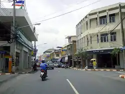
 Typical atmosphere of Phanat Nikhom | |
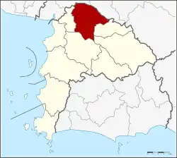
 District location in Chonburi province | |
| Coordinates: 13°27′8″N 101°10′38″E / 13.45222°N 101.17722°E | |
| Country | Thailand |
| Province | Chonburi |
| Seat | Phanat Nikhom |
| Tambon | 20 |
| Area | |
| • Total | 450.9 km2 (174.1 sq mi) |
| Population (2015) | |
| • Total | 123,213 |
| • Density | 273.26/km2 (707.7/sq mi) |
| Time zone | UTC+7 (ICT) |
| Postal code | 20140 |
| Geocode | 2006 |
Phanat Nikhom (Thai: พนัสนิคม, pronounced [pʰā.nát ní(ʔ).kʰōm]) is a district (amphoe) in the northern part of Chonburi province, eastern Thailand.
History
Phanat Nikhom is an ancient city dating back to Dvaravati period, called Mueang Phra Rot. Archaeologists found a fortress and city walls within the district area. In the Rattanakosin era, King Nangklao, Rama III established city, called Mueang Phanat Nikhom in 1828. It was changed to be a district of Mueang Chon Buri by King Chulalongkorn , Rama V in 1904. Phanat Nikhom was divided into new five districts: Phan Thong, Nong Yai, Bo Thong, Ko Chan and Nong Irun, Nong Chak, Nong Bon Daeng sub-district in Ban Bueng.
In Mon Nang sub-district, there is a shrine to the Twelve Sisters with the rock they used as pillow when they wandered in the wilderness, as well as a Carissa carandas tree related to the legend.[1]
Geography
Neighboring districts are (from east clockwise), Ko Chan, Bo Thong, Ban Bueng, Phan Thong of Chonburi Province, Ban Pho and Plaeng Yao of Chachoengsao province).
Administration
The district is divided into 20 sub-districts (tambons), which are further subdivided into 185 villages (mubans). The town (thesaban mueang) Phanat Nikhom covers the whole tambon Phanat Nikhom. Each of the other 19 tambons is led by a tambon administrative organization (TAO).
| No. | Name | Thai | Pop. |
|---|---|---|---|
| 1. | Phanat Nikhom | พนัสนิคม | 11,912 |
| 2. | Na Phrathat | หน้าพระธาตุ | 4,840 |
| 3. | Wat Luang | วัดหลวง | 2,781 |
| 4. | Ban Soet | บ้านเซิด | 3,369 |
| 5. | Na Roek | นาเริก | 8,821 |
| 6. | Mon Nang | หมอนนาง | 13,614 |
| 7. | Sa Si Liam | สระสี่เหลี่ยม | 6,772 |
| 8. | Wat Bot | วัดโบสถ์ | 3,054 |
| 9. | Kut Ngong | กุฎโง้ง | 5,283 |
| 10. | Hua Thanon | หัวถนน | 4,890 |
| 11. | Tha Kham | ท่าข้าม | 2,882 |
| 13. | Nong Prue | หนองปรือ | 5,232 |
| 14. | Nong Khayat | หนองขยาด | 4,028 |
| 15. | Thung Khwang | ทุ่งขวาง | 4,158 |
| 16. | Nong Hiang | หนองเหียง | 12,924 |
| 17. | Na Wang Hin | นาวังหิน | 7,047 |
| 18. | Ban Chang | บ้านช้าง | 5,936 |
| 20. | Khok Phlo | โคกเพลาะ | 2,746 |
| 21. | Rai Lak Thong | ไร่หลักทอง | 3,386 |
| 22. | Na Matum | นามะตูม | 2,764 |
Missing numbers are tambon which now form Ko Chan District.
References
- ↑ "Phra Rot Meri - Chonburi". Archived from the original on 2013-04-18. Retrieved 2012-09-23.
External links