| Paisley and Renfrewshire North | |
|---|---|
| County constituency for the House of Commons | |
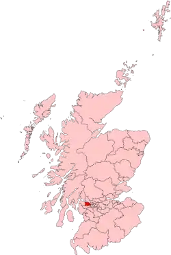
 Boundary of Paisley and Renfrewshire North in Scotland | |
| Major settlements | Bishopton |
| Current constituency | |
| Created | 2005 |
| Member of Parliament | Gavin Newlands (SNP) |
| Created from | Paisley South, Paisley North and Renfrewshire West |
Paisley and Renfrewshire North is a constituency of the House of Commons of the Parliament of the United Kingdom. It was created for the 2005 general election, replacing most of Paisley North and Renfrewshire West.
Constituency Profile
The constituency covers the northern portion of Paisley, the smaller towns of Renfrew and Linwood, and rural villages such as Bishopton, Bridge of Weir and Houston.
Boundaries
The constituency includes the northern part of Paisley, plus the towns of
and also Glasgow Airport and Hillington Industrial Estate.
The northern boundary of the constituency is the River Clyde from Braehead in the east to Langbank in the west.
A map of the constituency can be found at the Election Maps site.
Members of Parliament
| Election | Member | Party | |
|---|---|---|---|
| 2005 | Jim Sheridan | Labour | |
| 2015 | Gavin Newlands | SNP | |
Elections
Elections in the 2010s
| Party | Candidate | Votes | % | ±% | |
|---|---|---|---|---|---|
| SNP | Gavin Newlands | 23,353 | 47.0 | +9.6 | |
| Labour | Alison Taylor | 11,451 | 23.0 | -8.8 | |
| Conservative | Julie Pirone | 11,217 | 22.6 | -4.9 | |
| Liberal Democrats | Ross Stalker | 3,661 | 7.4 | +4.2 | |
| Majority | 11,902 | 24.0 | +18.4 | ||
| Turnout | 49,682 | 69.0 | -0.1 | ||
| SNP hold | Swing | +9.2 | |||
| Party | Candidate | Votes | % | ±% | |
|---|---|---|---|---|---|
| SNP | Gavin Newlands | 17,455 | 37.4 | -13.3 | |
| Labour | Alison Taylor | 14,842 | 31.8 | -0.9 | |
| Conservative | David Gardiner | 12,842 | 27.5 | +15.2 | |
| Liberal Democrats | John Boyd | 1,476 | 3.2 | +1.1 | |
| Majority | 2,613 | 5.6 | -12.4 | ||
| Turnout | 46,615 | 69.1 | -7.1 | ||
| SNP hold | Swing | -6.2 | |||
| Party | Candidate | Votes | % | ±% | |
|---|---|---|---|---|---|
| SNP | Gavin Newlands | 25,601 | 50.7 | +31.6 | |
| Labour | Jim Sheridan | 16,525 | 32.7 | -21.3 | |
| Conservative | John Anderson | 6,183 | 12.3 | -2.3 | |
| Liberal Democrats | James Speirs | 1,055 | 2.1 | -8.4 | |
| Scottish Green | Ryan Morrison | 703 | 1.4 | New | |
| CISTA | Andy Doyle | 202 | 0.4 | New | |
| TUSC | Jim Halfpenny[5] | 193 | 0.4 | New | |
| Majority | 9,076 | 18.0 | N/A | ||
| Turnout | 50,462 | 76.2 | +7.6 | ||
| SNP gain from Labour | Swing | +26.5 | |||
| Party | Candidate | Votes | % | ±% | |
|---|---|---|---|---|---|
| Labour | Jim Sheridan | 23,613 | 54.0 | +8.3 | |
| SNP | Mags MacLaren | 8,333 | 19.1 | +0.3 | |
| Conservative | Alistair Campbell | 6,381 | 14.6 | +1.0 | |
| Liberal Democrats | Ruaraidh Dobson | 4,597 | 10.5 | -7.8 | |
| Independent | Gary Pearson | 550 | 1.3 | New | |
| Scottish Socialist | Chris Rollo | 233 | 0.5 | -1.1 | |
| Majority | 15,280 | 34.9 | +8.0 | ||
| Turnout | 43,707 | 68.6 | +3.8 | ||
| Labour hold | Swing | +4.3 | |||
Elections in the 2000s
| Party | Candidate | Votes | % | ±% | |
|---|---|---|---|---|---|
| Labour | Jim Sheridan | 18,697 | 45.7 | -6.6 | |
| SNP | Bill Wilson | 7,696 | 18.8 | -3.9 | |
| Liberal Democrats | Lewis Hutton | 7,464 | 18.3 | +10.7 | |
| Conservative | Philip Lardner | 5,566 | 13.6 | -0.1 | |
| Scottish Socialist | Angela McGregor | 646 | 1.6 | -1.7 | |
| Socialist Labour | Katharine McGavigan | 444 | 1.1 | New | |
| UKIP | John Pearson | 372 | 0.9 | New | |
| Majority | 11,001 | 26.9 | -2.7 | ||
| Turnout | 40,885 | 64.8 | +3.6 | ||
| Labour hold | Swing | -1.3 | |||
This constituency was formed in 2005 from parts of the old Paisley North and West Renfrewshire constituencies.
References
- Specific
- ↑ "2019 - UK General Election". Renfrewshire Council. Renfrewshire Council. Archived from the original on 13 December 2019. Retrieved 13 December 2019.
- ↑ "Paisley & Renfrewshire North parliamentary constituency - Election 2019". BBC News. Archived from the original on 4 December 2019. Retrieved 16 December 2019.
- ↑ "UK Parliamentary General Election: Paisley and Renfrewshire North Constituency Statement of Persons Nominated and Notice of Poll" (PDF). Archived (PDF) from the original on 5 September 2019. Retrieved 18 May 2017.
- ↑ "Election Data 2015". Electoral Calculus. Archived from the original on 17 October 2015. Retrieved 17 October 2015.
- ↑ "TUSC parliamentary candidates in May 2015" (PDF). Trade Unionist and Socialist Coalition. 4 February 2015. Archived (PDF) from the original on 7 February 2015.
- ↑ "Election Data 2010". Electoral Calculus. Archived from the original on 26 July 2013. Retrieved 17 October 2015.
- ↑ "Election Data 2005". Electoral Calculus. Archived from the original on 15 October 2011. Retrieved 18 October 2015.
- General