Nemuro
根室市 | |
|---|---|
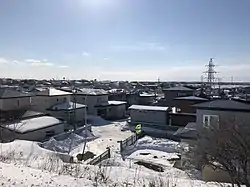 Nemuro City in 2019 | |
 Flag  Seal | |
 Location of Nemuro in Hokkaido (Nemuro Subprefecture) | |
 Nemuro Location in Japan | |
| Coordinates: 43°19′48″N 145°34′58″E / 43.33000°N 145.58278°E | |
| Country | Japan |
| Region | Hokkaido |
| Prefecture | Hokkaido (Nemuro Subprefecture) |
| First official recorded | 1635 |
| City settled | August 1, 1957 |
| Government | |
| • Mayor | Masatoshi Ishigaki |
| Area | |
| • Total | 512.63 km2 (197.93 sq mi) |
| Population (September 30, 2016) | |
| • Total | 27,109 |
| • Density | 56.74/km2 (147.0/sq mi) |
| Time zone | UTC+09:00 (JST) |
| City hall address | 2-27 Tokiwachō, Nemuro-shi, Hokkaido 087-8711 |
| Website | www |
| Symbols | |
| Bird | Swan |
| Flower | Yukiwarikozakura (Primula modesta var. fauriei) |
| Tree | Chishimazakura (Prunus nipponica var. kurilensis) |
Nemuro (根室市, Nemuro-shi, Ainu: Ni-mu-oro) is a city and port located in Nemuro Subprefecture, Hokkaido, Japan. It is the capital city of Nemuro Subprefecture. Much of the city lies on the Nemuro Peninsula. As of February 29, 2012, the city has an estimated population of 29,087, with 12,966 households, and a population density of 56.74 persons per km2 (147.0 persons per sq. mi.). The total area is 512.63 km2 (197.93 sq mi).
History
Nemuro was developed by fisheries. In the early Meiji period, it was the largest city in eastern Hokkaido.[1]
- 1900 Nemuro town was founded.
- 1906 Wada village was founded.
- 1945 Bombed by American naval aircraft, 393 people were killed.[2]
- 1915 Habomai village was founded.
- 1957 Nemuro town and Wada village was merged to form Nemuro city.
- 1959 Habomai village was merged into Nemuro city.
Climate
Nemuro, like most of Hokkaido, has a humid continental climate (Köppen climate classification Dfb), but not far from a marine climate (Koppen: Cfb) due to its low amplitude for a location close to mainland Asia and average temperatures during the winter.[3] It has mild to warm summers and cold snowy winters. Like the more northerly Kuril Islands, it has an extremely strong seasonal lag, with the highest temperatures in August and September and lowest in February, though it is not so gloomy as extremely foggy North Pacific islands like Simushir or the Aleutian Islands in general. Its peninsular location makes Nemuro very windy, especially during autumn and winter, with mean wind speeds as high as 22.7 kilometres per hour (14.1 mph) in November.
| Climate data for Nemuro (1991−2020 normals, extremes 1879−present) | |||||||||||||
|---|---|---|---|---|---|---|---|---|---|---|---|---|---|
| Month | Jan | Feb | Mar | Apr | May | Jun | Jul | Aug | Sep | Oct | Nov | Dec | Year |
| Record high °C (°F) | 10.3 (50.5) |
9.5 (49.1) |
14.7 (58.5) |
23.3 (73.9) |
34.0 (93.2) |
32.1 (89.8) |
33.1 (91.6) |
33.6 (92.5) |
29.5 (85.1) |
24.2 (75.6) |
19.2 (66.6) |
13.4 (56.1) |
34.0 (93.2) |
| Mean daily maximum °C (°F) | −0.9 (30.4) |
−1.2 (29.8) |
2.2 (36.0) |
7.4 (45.3) |
11.9 (53.4) |
14.9 (58.8) |
18.7 (65.7) |
20.9 (69.6) |
19.4 (66.9) |
14.7 (58.5) |
8.6 (47.5) |
2.1 (35.8) |
9.9 (49.8) |
| Daily mean °C (°F) | −3.4 (25.9) |
−3.8 (25.2) |
−0.8 (30.6) |
3.5 (38.3) |
7.7 (45.9) |
10.9 (51.6) |
14.9 (58.8) |
17.4 (63.3) |
16.2 (61.2) |
11.6 (52.9) |
5.6 (42.1) |
−0.5 (31.1) |
6.6 (43.9) |
| Mean daily minimum °C (°F) | −6.5 (20.3) |
−7.1 (19.2) |
−3.7 (25.3) |
0.5 (32.9) |
4.5 (40.1) |
8.1 (46.6) |
12.1 (53.8) |
14.8 (58.6) |
13.6 (56.5) |
8.5 (47.3) |
2.3 (36.1) |
−3.6 (25.5) |
3.6 (38.5) |
| Record low °C (°F) | −22.7 (−8.9) |
−22.9 (−9.2) |
−21.1 (−6.0) |
−13.4 (7.9) |
−6.7 (19.9) |
−4.9 (23.2) |
0.4 (32.7) |
6.3 (43.3) |
1.7 (35.1) |
−3.3 (26.1) |
−10.6 (12.9) |
−15.1 (4.8) |
−22.9 (−9.2) |
| Average precipitation mm (inches) | 30.6 (1.20) |
23.5 (0.93) |
47.0 (1.85) |
64.4 (2.54) |
96.2 (3.79) |
103.0 (4.06) |
115.1 (4.53) |
132.3 (5.21) |
160.0 (6.30) |
126.1 (4.96) |
83.2 (3.28) |
59.0 (2.32) |
1,040.4 (40.96) |
| Average snowfall cm (inches) | 43 (17) |
39 (15) |
36 (14) |
12 (4.7) |
0 (0) |
0 (0) |
0 (0) |
0 (0) |
0 (0) |
0 (0) |
2 (0.8) |
28 (11) |
159 (63) |
| Average precipitation days (≥ 0.5 mm) | 9.7 | 6.3 | 9.4 | 10.6 | 11.3 | 10.1 | 11.0 | 11.8 | 11.5 | 10.7 | 10.8 | 10.4 | 123.6 |
| Average relative humidity (%) | 71 | 72 | 75 | 78 | 83 | 89 | 91 | 89 | 84 | 76 | 70 | 69 | 79 |
| Mean monthly sunshine hours | 154.4 | 164.1 | 190.8 | 180.9 | 171.6 | 135.5 | 117.3 | 124.6 | 144.5 | 162.8 | 148.2 | 151.8 | 1,846.7 |
| Source: Japan Meteorological Agency[4] | |||||||||||||
See or edit raw graph data.
Transportation
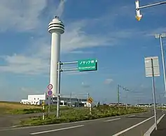
Air
Nearby Nakashibetsu Airport serves Nemuro.
Rail
- Hokkaido Railway Company – Nemuro Main Line
- Stations in the city: Nemuro - Higashi-Nemuro - Nishi-Wada - Kombumori - Ochiishi - Bettoga - Attoko
Road
Sightseeing


- Cape Nosappu
- Cape Hanasaki, including "Kurumaishi", a car wheel-shaped stone natural monument
- Cape Ochiishi, a fishing port
- The Ruins of Chashi in the Nemuro Peninsula
- Roadside station Swan 44 Nemuro
- Lake Furen
- Shunkunitai Wild Bird Sanctuary
- Habomai Fishing Port
- Kotohira Shrine
- Meiji Park
- Ohashi Bridge
- Lake Onnetō
Cuisine
One local specialty of Nemuro is "escalope". This consists of tonkatsu (breaded deep-fried pork cutlets) over butter fried rice with a special demiglace sauce.[5]
Nemuro is well known by the people of Hokkaido as one of the best places to eat sushi because of the seafood caught there.[5][6] Nemuro is also the origin of two sushi restaurants in Hokkaido: Matsuriya[7] and Hanamaru.[8] Nemuro's seafood delicacies include their fresh Pacific saury, salmon, king crab, and shrimp.
Other delicacies in Nemuro include yakitori bento, Holland sanbei (waffle-like snack), soft serve ice cream, and monjayaki.
Economy
Nemuro's economy is based on its fishing industry as many types of marine animals are found in the area all year long. Dairy processing is also an important part of the local economy.[9] Local businesses like restaurants and tourism also plays a significant role in the economy. Nemuro boasts the largest catches of saury in all of Japan, which has led to efforts to export saury to Southeast Asia, especially Vietnam.[10]
Education
High schools
- Hokkaido Nemuro High School
Mascot

Nemuro's mascot is Nemuro-kun (ねむろうくん). He is a fisherman owl who stores seafood products in his pocket. He is asleep and usually sleep-walks during the day but is active during the night. He was unveiled in April 2016.[11]
Sister cities
Nemuro is twinned with the following sister cities:[12]
 Sitka, Alaska, United States
 Severo-Kurilsk, Russia
 Kurobe, Toyama, Japan
 Tebedu, Sarawak, Malaysia
References
- ↑ "History of Nemuro". Archived from the original on 2015-09-08. Retrieved 2015-05-18.
- ↑ The Asahi Shimbun. "朝日新聞デジタル:空襲の記憶 風化させぬ - 北海道 - 地域". www.asahi.com (in Japanese). Archived from the original on 14 April 2022. Retrieved 2022-04-13.
- ↑ "Koppen Climate Classification" (PDF).
- ↑ 気象庁 / 平年値(年・月ごとの値). Japan Meteorological Agency. Retrieved May 19, 2021.
- 1 2 "The Food of Nemuro". Nemuro Tourist Information. Japan: Nemuro Tourist Association. Retrieved 2014-09-03.
- ↑ "Nemuro - DavisHunter.com". www.davishunter.com. Retrieved 2017-12-14.
- ↑ "回転寿司まつりやは、札幌、十勝、釧路、道内9店舗 美味しいお寿司をご提供". 26 September 2019.
- ↑ "回転寿司 根室花まる / 町のすし家 四季花まる". 回転寿司 根室花まる / 町のすし家 四季花まる.
- ↑ "Nemuro". britannica.com. Retrieved 14 December 2019.
- ↑ "Port city Nemuro sets the hook in promoting saury exports to Vietnam". The Japan Times. 27 April 2013. Retrieved 14 December 2019.
- ↑ "眠郎のお部屋". Nemuro.
- ↑ "Sister-City Relationships in Hokkaido". Archived from the original on February 24, 2015.
External links
 Nemuro travel guide from Wikivoyage
- Official Website (in Japanese)
- English Website