Nagato
長門市 | |
|---|---|
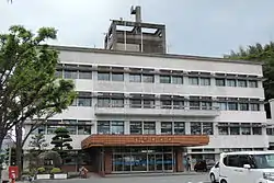
 Nagato city hall | |
 Flag  Emblem | |
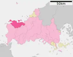
Location of Nagato in Yamaguchi Prefecture | |
 | |
 Nagato Location in Japan | |
| Coordinates: 34°22′14″N 131°10′57″E / 34.37056°N 131.18250°E | |
| Country | Japan |
| Region | Chūgoku (San'yō) |
| Prefecture | Yamaguchi |
| Government | |
| • Mayor | Tatsuya Ehara |
| Area | |
| • Total | 357.31 km2 (137.96 sq mi) |
| Population (February 28, 2023) | |
| • Total | 31,518 |
| • Density | 88/km2 (230/sq mi) |
| Time zone | UTC+09:00 (JST) |
| City hall address | 1339-2 Higashifukagawa, Nagato-shi, Yamaguchi-ken 759-4192 |
| Climate | Cfa |
| Website | Official website |
| Symbols | |
| Flower | Sakura and Azalea |
| Insect | Firefly |
| Tree | Sakura and Azalea |


Nagato (長門市, Nagato-shi) is a city in Yamaguchi Prefecture, Japan. As of 28 February 2023, the city had an estimated population of 31,518 in 15537 households and a population density of 88 persons per km².[1] The total area of the city is 357.31 square kilometres (137.96 sq mi).
Geography
Nagato is located in northwestern Yamaguchi. The north side faces the Sea of Japan, and the coastline facing the open sea is eroded terrain. On the other hand, there are coves such as Fukagawa Bay and Senzaki Bay, which are surrounded by the island of Ōmijima and the mainland, and Aburaya Bay, which is surrounded by the Mukatsugu Peninsula, which are good natural harbors. Since the Mukatsugu Peninsula has little flat land, there are many terraced rice fields. The southern part of the city is on the western edge of the Chugoku Mountains, and snow can be seen in the mountainous areas. However, due to the influence of the Tsushima Current, it does not get extremely cold even in winter, and because the altitude is not so high, the number of snowy days is not so many. Nagato also encompasses Ōmijima Island in the Sea of Japan, which is connected by a large road bridge which connects the Senzaki Peninsula with the southern edge of the island. Much of the island is within the borders of the Kita-Nagato Kaigan Quasi-National Park.
Neighboring municipalities
Yamaguchi Prefecture
Climate
Nagato has a humid subtropical climate (Köppen climate classification Cfa) with hot summers and cool winters. Precipitation is significant throughout the year, but is much higher in summer than in winter. The average annual temperature in Nagato is 15.9 °C (60.6 °F). The average annual rainfall is 1,790.8 mm (70.50 in) with July as the wettest month. The temperatures are highest on average in August, at around 27.1 °C (80.8 °F), and lowest in January, at around 5.8 °C (42.4 °F).[2] The highest temperature ever recorded in Nagato was 36.7 °C (98.1 °F) on 14 August 2018; the coldest temperature ever recorded was −6.1 °C (21.0 °F) on 26 February 1981.[3]
| Climate data for Yuya, Nagato (1991−2020 normals, extremes 1977−present) | |||||||||||||
|---|---|---|---|---|---|---|---|---|---|---|---|---|---|
| Month | Jan | Feb | Mar | Apr | May | Jun | Jul | Aug | Sep | Oct | Nov | Dec | Year |
| Record high °C (°F) | 18.6 (65.5) |
23.2 (73.8) |
25.5 (77.9) |
29.5 (85.1) |
30.7 (87.3) |
33.4 (92.1) |
35.7 (96.3) |
36.7 (98.1) |
35.2 (95.4) |
31.9 (89.4) |
27.0 (80.6) |
23.9 (75.0) |
36.7 (98.1) |
| Mean daily maximum °C (°F) | 9.5 (49.1) |
10.5 (50.9) |
13.8 (56.8) |
18.7 (65.7) |
23.2 (73.8) |
26.0 (78.8) |
29.9 (85.8) |
31.3 (88.3) |
27.4 (81.3) |
22.6 (72.7) |
17.4 (63.3) |
12.0 (53.6) |
20.2 (68.3) |
| Daily mean °C (°F) | 5.8 (42.4) |
6.4 (43.5) |
9.3 (48.7) |
13.9 (57.0) |
18.4 (65.1) |
21.9 (71.4) |
26.1 (79.0) |
27.1 (80.8) |
23.1 (73.6) |
17.8 (64.0) |
12.8 (55.0) |
8.0 (46.4) |
15.9 (60.6) |
| Mean daily minimum °C (°F) | 1.8 (35.2) |
2.0 (35.6) |
4.4 (39.9) |
8.7 (47.7) |
13.6 (56.5) |
18.3 (64.9) |
22.9 (73.2) |
23.7 (74.7) |
19.5 (67.1) |
13.2 (55.8) |
8.1 (46.6) |
3.8 (38.8) |
11.7 (53.0) |
| Record low °C (°F) | −5.2 (22.6) |
−6.1 (21.0) |
−3.6 (25.5) |
−1.1 (30.0) |
3.1 (37.6) |
7.9 (46.2) |
13.7 (56.7) |
15.9 (60.6) |
7.0 (44.6) |
2.8 (37.0) |
−0.4 (31.3) |
−3.5 (25.7) |
−6.1 (21.0) |
| Average precipitation mm (inches) | 97.8 (3.85) |
86.8 (3.42) |
137.7 (5.42) |
130.4 (5.13) |
146.2 (5.76) |
222.5 (8.76) |
279.7 (11.01) |
198.3 (7.81) |
202.0 (7.95) |
106.5 (4.19) |
99.4 (3.91) |
83.5 (3.29) |
1,790.8 (70.50) |
| Average precipitation days (≥ 1.0 mm) | 11.3 | 10.6 | 11.4 | 10.2 | 9.2 | 11.5 | 11.4 | 9.0 | 10.7 | 8.0 | 10.0 | 10.4 | 123.7 |
| Mean monthly sunshine hours | 83.5 | 101.0 | 151.2 | 182.0 | 204.1 | 137.3 | 164.1 | 197.4 | 143.5 | 156.9 | 116.6 | 86.3 | 1,723.8 |
| Source: Japan Meteorological Agency[2][3] | |||||||||||||
Demographics
Per Japanese census data, the population of Nagato in 2020 is 32,519 people.[4] Nagato has been conducting censuses since 1920.
| Year | Pop. | ±% |
|---|---|---|
| 1920 | 49,511 | — |
| 1925 | 50,249 | +1.5% |
| 1930 | 50,855 | +1.2% |
| 1935 | 50,753 | −0.2% |
| 1940 | 50,776 | +0.0% |
| 1945 | 64,030 | +26.1% |
| 1950 | 64,281 | +0.4% |
| 1955 | 66,112 | +2.8% |
| 1960 | 62,866 | −4.9% |
| 1965 | 57,669 | −8.3% |
| 1970 | 53,247 | −7.7% |
| 1975 | 51,421 | −3.4% |
| 1980 | 50,892 | −1.0% |
| 1985 | 50,259 | −1.2% |
| 1990 | 47,656 | −5.2% |
| 1995 | 45,565 | −4.4% |
| 2000 | 43,473 | −4.6% |
| 2005 | 41,127 | −5.4% |
| 2010 | 38,317 | −6.8% |
| 2015 | 35,439 | −7.5% |
| 2020 | 32,519 | −8.2% |
| Nagato population statistics[4] | ||
History
The area of Nagato was part of ancient Nagato Province. During the Edo Period, the area was part of the holdings of Chōshū domain. After the Meiji restoration, the area was divided into eight villages within Ōtsu District, Yamaguchi with the creation of the modern municipalities system. Senzaki was raised to town status on April 15, 1914, followed by Fukagawa on November 1, 1928. The city of Nagato was established on March 31, 1954 by the merger of Fukawa and Senzaki, with the villages of Kayoi and Tawarayama. On March 22, 2005 the city annexed the villages of Yuya, Heki and Misumi with the district of Ōtsu dissolved by this merger.
Government
Nagato has a mayor-council form of government with a directly elected mayor and a unicameral city council of 18 members. Nagato conributes one member to the Yamaguchi Prefectural Assembly. In terms of national politics, the city is part of the Yamaguchi 4th district of the lower house of the Diet of Japan.
In the 2017 Japanese general election, 76.25% of Nagato's proportional ballots were cast for either one of the two parties in the conservative ruling coalition (the Liberal Democratic Party and Komeito) or one of the two minor LDP-allied conservative parties (Party for Japanese Kokoro) and New Party Daichi), making it the most conservative city in the country for that election under this definition, and the second most conservative municipality overall behind Himeshima, Ōita.[5]
Economy
The main industries in Nagato are commercial fishing, agriculture, animal husbandry and food processing. Fujimitsu Corporation, a manufacturer of fish surimi products, is headquartered in the city.[6] The tourism industry is also a major component of the local economy.
Education
Nagato has 12 public elementary school and five public junior high schools operated by the city government, and one public high school operated by the Yamaguchi Prefectural Board of Education. There are also one private high school.
Transportation
Railway
![]() JR West (JR West) - San'in Main Line
JR West (JR West) - San'in Main Line
- Nagato-Misumi - Nagatoshi - Kiwado - Nagato-Furuichi - Hitomaru - Igami
![]() JR West (JR West) - San'in Main Line (branch line)
JR West (JR West) - San'in Main Line (branch line)
Highways
Noted people from Nagato
- Kan Abe, politician
- Misuzu Kaneko, poet
References
- ↑ "Nagato City official statistics" (in Japanese). Japan.
- 1 2 気象庁 / 平年値(年・月ごとの値). JMA. Retrieved May 27, 2022.
- 1 2 観測史上1~10位の値(年間を通じての値). JMA. Retrieved May 27, 2022.
- 1 2 Nagato population statistics
- ↑ "平成29年10月22日執行 衆議院議員総選挙 市区町村別得票数". Ministry of Internal Affairs and Communications.
- ↑ "Corporate Information". Fujimitsu Corporation. Retrieved December 6, 2018.
External links
 Media related to Nagato, Yamaguchi at Wikimedia Commons
- Nagato City official website (in Japanese)