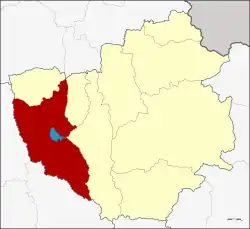
Mueang Phayao
เมืองพะเยา | |
|---|---|
 District location in Phayao province | |
| Coordinates: 19°11′31″N 99°52′43″E / 19.19194°N 99.87861°E | |
| Country | Thailand |
| Province | Phayao |
| Seat | Ban Tom |
| Area | |
| • Total | 842.1 km2 (325.1 sq mi) |
| Population (2014) | |
| • Total | 126,750 |
| • Density | 143.8/km2 (372/sq mi) |
| Time zone | UTC+7 (ICT) |
| Postal code | 56000 |
| Geocode | 5601 |
Mueang Phayao (Thai: เมืองพะเยา, pronounced [mɯ̄a̯ŋ pʰā.jāw]) is the capital district (amphoe mueang) of Phayao province, northern Thailand.
Geography
Neighboring districts are (from the north clockwise): Mai Chai of Phayao Province; Pa Daet of Chiang Rai province; Phu Kamyao, Dok Khamtai of Phayao Province; Ngao and Wang Nuea of Lampang province.
Doi Luang, the highest point of the Phi Pan Nam Range is at the western end of the district.[1]
History
In 1917 Phayao district was renamed Mueang Phayao.[2] In 1938 the word "mueang" was removed, as only the capital districts of the provinces were to have that name.[3] With the creation of Phayao Province in 1977, the district was named Mueang Phayao again.[4]
Administration
Central administration
Mueang Phayao district is divided into 15 sub-districts (tambons), which are further subdivided into 172 administrative villages (mubans).
| No. | Name | Thai | Villages | Pop.[5] |
|---|---|---|---|---|
| 1. | Wiang | เวียง | - | 9,773 |
| 2. | Mae Tam | แม่ต๋ำ | - | 7,694 |
| 4. | Mae Na Ruea | แม่นาเรือ | 18 | 8,872 |
| 5. | Ban Tun | บ้านตุ่น | 11 | 4,944 |
| 6. | Ban Tam | บ้านต๊ำ | 13 | 7,274 |
| 7. | Ban Tom | บ้านต๋อม | 18 | 12,462 |
| 8. | Mae Puem | แม่ปืม | 18 | 9,250 |
| 10. | Mae Ka | แม่กา | 18 | 20,019 |
| 11. | Ban Mai | บ้านใหม่ | 9 | 4,761 |
| 12. | Cham Pa Wai | จำป่าหวาย | 13 | 8,454 |
| 13. | Tha Wang Thong | ท่าวังทอง | 14 | 15,097 |
| 14. | Mae Sai | แม่ใส | 12 | 6,263 |
| 15. | Ban Sang | บ้านสาง | 9 | 4,339 |
| 16. | Tha Champi | ท่าจำปี | 11 | 3,935 |
| 18. | San Pa Muang | สันป่าม่วง | 8 | 3,613 |
Missing numbers belong to tambons which now form Phu Kamyao District.
Local administration
There is one town (Thesaban Mueang) in the district:
- Phayao (Thai: เทศบาลเมืองพะเยา) consisting of sub-district Wiang, Mae Tam.
There are nine sub-district municipalities (thesaban tambons) in the district:
- Tha Wang Thong (Thai: เทศบาลตำบลท่าวังทอง) consisting of sub-district Tha Wang Thong.
- Ban Tam (Thai: เทศบาลตำบลบ้านต๊ำ) consisting of sub-district Ban Tam.
- Mae Puem (Thai: เทศบาลตำบลแม่ปืม) consisting of sub-district Mae Puem.
- Mae Ka (Thai: เทศบาลตำบลแม่กา) consisting of sub-district Mae Ka.
- Ban Tom (Thai: เทศบาลตำบลบ้านต๋อม) consisting of sub-district Ban Tom.
- Ban Mai (Thai: เทศบาลตำบลบ้านใหม่) consisting of sub-district Ban Mai.
- Ban Sang (Thai: เทศบาลตำบลบ้านสาง) consisting of sub-district Ban Sang.
- Tha Champi (Thai: เทศบาลตำบลท่าจำปี) consisting of sub-district Tha Champi.
- San Pa Muang (Thai: เทศบาลตำบลสันป่าม่วง) consisting of sub-district San Pa Muang.
There are four sub-district administrative organizations (SAO) in the district:
- Mae Na Ruea (Thai: องค์การบริหารส่วนตำบลแม่นาเรือ) consisting of sub-district Mae Na Ruea.
- Ban Tun (Thai: องค์การบริหารส่วนตำบลบ้านตุ่น) consisting of sub-district Ban Tun.
- Cham Pa Wai (Thai: องค์การบริหารส่วนตำบลจำป่าหวาย) consisting of sub-district Cham Pa Wai.
- Mae Sai (Thai: องค์การบริหารส่วนตำบลแม่ใส) consisting of sub-district Mae Sai.
References
- ↑ Northern Thailand- Geography 3 Archived 2012-01-28 at the Wayback Machine
- ↑ ประกาศกระทรวงมหาดไทย เรื่อง เปลี่ยนชื่ออำเภอ (PDF). Royal Gazette (in Thai). 34 (ก): 40–68. 1917-04-29. Archived from the original (PDF) on November 7, 2011.
- ↑ พระราชกฤษฎีกาเปลี่ยนนามจังหวัด และอำเภอบางแห่ง พุทธศักราช ๒๔๘๑ (PDF). Royal Gazette (in Thai). 55 (ก): 658–666. 1938-11-14. Archived from the original (PDF) on November 8, 2011.
- ↑ พระราชบัญญัติตั้งจังหวัดพะเยา พ.ศ. ๒๕๒๐ (PDF). Royal Gazette (in Thai). 94 (69 ก ฉบับพิเศษ): 1–3. 1977-07-28. Archived from the original (PDF) on June 12, 2012.
- ↑ "Population statistics 2014" (in Thai). Department of Provincial Administration. Retrieved 2015-05-15.
External links
- amphoe.com (Thai)