| Maros-Torda County | |
|---|---|
| County of the Kingdom of Hungary (1876-1920, 1940-1945) | |
.svg.png.webp) Coat of arms
| |
 | |
| Capital | Marosvásárhely |
| Area | |
| • Coordinates | 46°33′N 24°34′E / 46.550°N 24.567°E |
• 1910 | 4,203 km2 (1,623 sq mi) |
| Population | |
• 1910 | 219589 |
| History | |
• Established | 1876 |
• Treaty of Trianon | 4 June 1920 |
• County recreated (Second Vienna Award) | 30 August 1940 |
• Disestablished | 1945 |
| Today part of | Romania |
| Târgu Mureș is the current name of the capital. | |
Maros-Torda was an administrative county (comitatus) of the Kingdom of Hungary. Its territory is now in central Romania (eastern Transylvania) and has been administratively succeeded by county Mureș which consist of about half the territory of the previous Maros-Torda administrative county. Its county seat was Marosvásárhely (present-day Târgu Mureș).
Geography

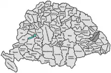
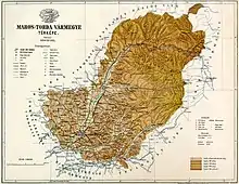
Maros-Torda county shared borders with the Hungarian counties Kolozs, Beszterce-Naszód, Csík, Udvarhely, Kis-Küküllő and Torda-Aranyos. The river Mureș flowed through the county. Its area was 4,188 km2 around 1910.
History
Maros-Torda county was formed in 1876 on the territory of the Székely seat of Marosszék and part of Torda County. In 1920, after the Treaty of Trianon, the county became part of Romania, except after the Second Vienna Award, between 1940 until the end of World War II, when much of the county's territory was awarded to Hungary. Today, its territory lies in the present (larger) Romanian county Mureș.
Demographics

| Census | Total | Hungarian | Romanian | German | Other or unknown |
|---|---|---|---|---|---|
| 1880[1] | 158,999 | 86,497 (56.50%) | 53,650 (35.05%) | 6,274 (4.10%) | 6,658 (4.35%) |
| 1890[2] | 177,860 | 102,572 (57.67%) | 62,179 (34.96%) | 6,438 (3.62%) | 6,671 (3.75%) |
| 1900[3] | 197,618 | 119,810 (60.63%) | 67,402 (34.11%) | 7,446 (3.77%) | 2,960 (1.50%) |
| 1910[4] | 219,589 | 134,166 (61.10%) | 71,909 (32.75%) | 8,312 (3.79%) | 5,202 (2.37%) |
| Census | Total | Calvinist | Greek Catholic | Eastern Orthodox | Roman Catholic | Unitarian | Jewish | Lutheran | Other or unknown |
|---|---|---|---|---|---|---|---|---|---|
| 1880 | 158,999 | 64,522 (40.58%) | 35,636 (22.41%) | 24,151 (15.19%) | 19,450 (12.23%) | 6,451 (4.06%) | 2,999 (1.89%) | 5,592 (3.52%) | 198 (0.12%) |
| 1890 | 177,860 | 71,840 (40.39%) | 40,235 (22.62%) | 26,787 (15.06%) | 22,207 (12.49%) | 7,212 (4.05%) | 3,735 (2.10%) | 5,826 (3.28%) | 18 (0.01%) |
| 1900 | 197,618 | 78,907 (39.93%) | 44,507 (22.52%) | 28,989 (14.67%) | 26,046 (13.18%) | 7,917 (4.01%) | 5,000 (2.53%) | 6,205 (3.14%) | 47 (0.02%) |
| 1910 | 219,589 | 85,692 (39.02%) | 49,911 (22.73%) | 31,266 (14.24%) | 30,828 (14.04%) | 7,894 (3.59%) | 7,550 (3.44%) | 6,442 (2.93%) | 6 (0.00%) |
Subdivisions

Around 1910, the subdivisions of Maros-Torda county were:
| Districts (járás) | |
|---|---|
| District | Capital |
| Marosi alsó | Marosvásárhely (now Târgu Mureș) |
| Marosi felső | Marosvásárhely (now Târgu Mureș) |
| Nyárádszereda | Nyárádszereda (now Miercurea Nirajului) |
| Régeni alsó | Szászrégen (now Reghin) |
| Régeni felső | Magyarrégen (now Reghin-Sat) |
| Urban counties (törvényhatósági jogú város) | |
| Marosvásárhely (now Târgu Mureș) | |
| Urban districts (rendezett tanácsú város) | |
| Szászrégen (now Reghin) | |
See also
Notes
References
- ↑ "Az 1881. év elején végrehajtott népszámlálás főbb eredményei megyék és községek szerint rendezve, II. kötet (1882)". library.hungaricana.hu. Retrieved 28 September 2021.
- ↑ "A Magyar Korona országainak helységnévtára (1892)". library.hungaricana.hu. Retrieved 29 September 2021.
- ↑ "A MAGYAR KORONA ORSZÁGAINAK 1900". library.hungaricana.hu. Retrieved 29 September 2021.
- ↑ "KlimoTheca :: Könyvtár". Kt.lib.pte.hu. Retrieved 29 September 2021.
