Malenadu
Malnad | |
|---|---|
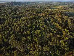
 Forests of Malenadu | |
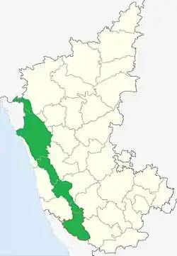
 Malenadu region shown in Green | |
| Country | |
| State | Karnataka |
| Region | Malenadu |
| Tehsil | Belagavi District Khanapur Uttara Kannada Sirsi Joida Dandeli Haliyal Yellapur Mundgod Siddapur Shivamogga District Sagara Hosanagara Soraba Shikaripura Bhadravati ThirthahalliChikkamagaluru District Sringeri Kalasa Koppa Narasimharajapura Mudigere Hassan District Sakleshpur Alur Belur Kodagu District Somwarpet Madikeri Virajpet Kushalanagar Ponnampet Dakshin Kannada Sullia |
| Languages | |
| • Official | Kannada |
| • Regional | Havyaka Kannada Kodava Tulu Konkani Arebhashe |
| Time zone | UTC+5:30 (IST) |
Malnad (or Malenadu) is a region in the state of Karnataka in India. Malenadu covers the western and eastern slopes of the Western Ghats or Sahyadri mountain range, and is roughly 100 kilometers in width. The region experiences heavy annual rainfall of 1000 to 3800 mm; it includes Agumbe, which receives the highest annual rainfall in Karnataka (over 10,000 mm).
In the Malnad area the villages are scattered throughout remote areas. This region in the state poses special problems of development mainly due to peculiar settlement, sparse population, topography, dense forest, numerous rivulets etc. In order to hasten the development of this area, l Area Development Board was created with the goal of achieving overall development of the Malnad area by implementing necessary development projects/works. The districts covered initially in this region were Shivamogga, Chikmagalur, Uttara Kannada, Kodagu and Hassan. At present the jurisdiction of the board covers part or all of 13 districts of the state, namely Chamarajnagar, Belgaum, Dharwar, Davangere, Haveri, Chikmagalur, Hassan, Shivamogga, Kodagu, Mysore, Uttarkannada, Udupi, and Mangalore.
These districts comprise 65 Assembly constituencies and 61 taluks. The area of operation of the Board notified by the Karnataka government is as follows:
- Belgaum
- Bailahongal, Belgaum, Hukkeri, Khanapur, Saudi
- Chikkamagalur
- Kadur, Koppa, Chikkamagalur, Mudigere, Narasimharajapur, Shringeri, Tarikere, Ajjampura
- Davanagere
- Channagiri, Honnali, Nyamathi
- Dharwad
- Dharwad, Kalaghatagi, Alnanavara
- Hassan
- Alur, Arakalagud, Belur, Hassan, Sakaleshpur
- Haveri
- Hangal, Hirekerur, Rettihalli, Byadagi, Savanur, Shiggaon
- Kodagu
- Madikeri, Somavarpet, Virajpet
- Dakshina Kannada
- Mangalore, Puttur, Sulya, Bantwal, Belthangadi, Mudubidri, Kadaba
- Mysore
- Heggadadevana kote, Hunasur, Periyapattana, Sargur
- Shivamogga
- Bhadravati, Shivamogga, Sagar, Sorab, Hosanagar, Thirthahalli, Shikaripura
- Udupi
- Udupi, Kundapur, Karkala, Brahmavara, Kapu, Byndoor, Hebri
- Ankola, Bhatkal, Haliyal, Honnavara, Karwar, Kumta, Mundagod, Siddapur, Sirsi, Joida, Yallapur, Dandeli
Climate and rainfall statistics
The Western Ghats acts as the rain barrier during south-west monsoon season. This region is one of the wettest regions in the world, with some rainfall measurements of over 7000mm
The following were the top 5 places that captured rainfall record statistics [2010-2017][1][2][3][4]
| Rank | Hobli/Village | District | Taluk | Year | Rainfall in mm | Elevation in metres |
|---|---|---|---|---|---|---|
| 1 | Amagaon | Belgaum district | Khanapur | 2010 | 10,068 | 785 |
| 2 | Mundrote | Kodagu district/Coorg District | Madikeri | 2011 | 9,974 | 585 |
| 3 | Hulikal | Shimoga district | Hosanagara | 2013 | 9,383 | 614 |
| 4 | Agumbe | Shimoga district | Thirthahalli | 2013 | 8,770 | 643 |
| 5 | Kokalli/Kakalli | Uttara Kannada | Sirsi | 2014 | 8,746 | 780 |
The table below is a comparison of rainfalls between Agumbe in Thirthahalli taluk in the Shimoga district, Hulikal in Hosanagara taluk in the Shimoga district, Amagaon in Khanapur Taluk in the Belgaum district and Talacauvery in Madikeri taluk in theKodagu district, Kokalli of Sirsi Taluk, Nilkund of Siddapur Taluk, CastleRock of Supa (Joida) Taluk in the Uttara Kannada District to show which one can be called the "Cherapunji of South India".[5]
| Year | Hulikal Rainfall (mm) | Agumbe Rainfall (mm) | Amagaon Rainfall (mm) | Talacauvery Rainfall (mm)[6] | Kokalli Rainfall (mm) | Nilkund Rainfall (mm) | Castle Rock Rainfall (mm) |
|---|---|---|---|---|---|---|---|
| 2017 | 5,700 | 6,311 | 4,733 | 5,859 | 3130 | 4981 | 5560 |
| 2016 | 5,721 | 6,449 | 4,705 | 5,430 | 2682 | 4655 | 4968 |
| 2015 | 6,035 | 5,518 | 4,013 | 5,319 | 2730 | 4367 | 3667 |
| 2014 | 7,907 | 7,917 | 5,580 | 7,844 | 8746 | 6710 | 5956 |
| 2013 | 9,383 | 8,770 | 8,440 | 8,628 | 4464 | 7082 | 3667 |
| 2012 | 8,409 | 6,933 | 5,987 | 5,722 | 5036 | 5398 | 6165 |
| 2011 | 8,523 | 7,921 | 9,368 | 6,855 | 4437 | 6593 | 7083 |
| 2010 | 7,717 | 6,929 | 10,068 | 6,794 | 4002 | - | - |
| 2009 | 8,357 | 7,982 | - | - | - | - | - |
| 2008 | 7,115 | 7,199 | - | - | - | - | - |
| 2007 | 9,038 | 8,255 | - | - | - | - | - |
| 2006 | 8,656 | 8,457 | - | - | -[7][8] | - | - |
See also
References
- ↑ "Rainfall Statistics for Kokalli (Ajjimane)" (PDF). DES Karnataka.
- ↑ "Rainfall Statistics for Amagaon" (PDF). DES Karnataka.
- ↑ "Rainfall Statistics for Mundrote" (PDF). DES Karnataka.
- ↑ "Rainfall Statistics for Agumbe and Hulikal" (PDF). DES karnataka.
- ↑ Hulikal in Shimoga district is wettest in State from TheHindu.com accessed 23 March 2013
- ↑ Amagaon has got over 10,000 mm annual rainfall twice in the five years (2006-2010). The exact amount of rainfall is not available. See Amagaon is now Cherrapunji of South from DeccanHerald.com accessed 23 March 2013
- ↑ "Govt of Karnataka Rainfall Statistics (Kokalli)" (PDF). DES.
- ↑ "Rainfall Statistics of Karnataka". DES Karnataka.