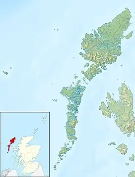
| Loch Bee Loch Bì | |
|---|---|
 Loch Bee Loch Bì | |
| Location | South Uist, Outer Hebrides, Scotland |
| Coordinates | 57°22′9.4″N 7°22′29″W / 57.369278°N 7.37472°W |
| Type | freshwater loch |
| Basin countries | Scotland |
| Max. length | 3 mi (5 km) |
| Max. width | 1 mi (1.5 km) |
| Islands | Limalum More, Eilean a' Charnan, Brostam More, Brostam Beg |
Loch Bì,[1] sometimes anglicised as Loch Bee, is the largest loch on the island of South Uist in the Outer Hebrides of Scotland. It lies at the northern end of the island
Loch Bì has an irregular shape, and measures about three miles (five kilometres) long by one mile (1.5 kilometres) in mean breadth. Its greatest depth is around 12 feet (3.5 metres; 2 fathoms). Loch Bì is reputed for its trout, flounder and mullet stock.[2]
Loch Bì is bisected by a causeway carrying the A865 road. The first causeway was built in the 17th century, with the existing structure having been completed in 1990.[3]
References
- ↑ Lochs Bi and Druidibeag (Potentially Vulnerable Area 02/07) – Comhairle nan Eilean Siar, February 2007
- ↑ "Loch Bee, from the Ordnance Gazetteer of Scotland: A Survey of Scottish Topography, Statistical, Biographical and Historical, edited by Francis H. Groome and originally published in parts by Thomas C. Jack, Grange Publishing Works, Edinburgh between 1882 and 1885". www.scottish-places.info. The Gazetteer for Scotland.
- ↑ "Loch Bee Causeway - Roader's Digest: The SABRE Wiki". www.sabre-roads.org.uk.
This article is issued from Wikipedia. The text is licensed under Creative Commons - Attribution - Sharealike. Additional terms may apply for the media files.