| Lax Kul Nii Luutiksm/Bonilla Conservancy | |
|---|---|
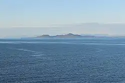
 Photo looking west in Hecate Strait toward Bonilla Island | |
 | |
| Location | British Columbia, Canada |
| Nearest city | Kitkatla |
| Coordinates | 53°29′13″N 130°36′30″W / 53.4869°N 130.6084°W / 53.4869; -130.6084 |
| Area | 1,584 ha (6.12 sq mi) |
| Designation | Conservancy |
| Established | July 13, 2006 |
| Governing body | BC Parks |
The Lax Kul Nii Luutiksm/Bonilla Conservancy was established in 2006 surrounding Bonilla Island (Lax Kul), located along the North Coast of British Columbia, Canada.[2]
The conservancy protects predator-free islets for seabirds and numerous marine and terrestrial species.[3] Located in this conservancy is a pre-contact Gitxaala village site and shell midden.
References
- ↑ "Canadian Protected and Conserved Areas Database (CPCAD)". Government of Canada. Retrieved 21 August 2023.
- ↑ "Lax Kul Nii Luutiksm/Bonilla Conservancy". bcparks.ca. B.C. Parks. Retrieved 21 June 2023.
- ↑ "Backgrounder: Amendments to the Park Act and Protected Areas of British Columbia Act". Government of British Columbia. Retrieved 21 June 2023.
This article is issued from Wikipedia. The text is licensed under Creative Commons - Attribution - Sharealike. Additional terms may apply for the media files.