| Smir Dam | |
|---|---|
.JPG.webp) | |
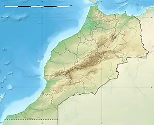
 Location of Smir Dam in Morocco | |
| Official name | Smir Barrage |
| Country | Morocco |
| Location | M'diq |
| Coordinates | 35°41′05.73″N 5°23′07.03″W / 35.6849250°N 5.3852861°W |
| Purpose | Water supply, irrigation |
| Status | Operational |
| Opening date | 1991 |
| Dam and spillways | |
| Type of dam | Embankment, earth-fill |
| Height | 45 m (148 ft) |
| Length | 600 m (2,000 ft) |
| Dam volume | 710,000 m3 (930,000 cu yd) |
| Spillway type | Uncontrolled bell-mouth |
| Reservoir | |
| Total capacity | 43,500,000 m3 (35,300 acre⋅ft)[1] |
| Catchment area | 75 km2 (29 sq mi) |
| Official name | Lagune et barrage de Smir |
| Designated | 22 May 2019 |
| Reference no. | 2380[2] |
Smir Dam (Barage Smir) is an earth-filled embankment dam in northern Morocco, to the southeast of Nakhla Dam and 5 km (3.1 mi) west of M'diq. It is at the confluence of the Smir and El-lile wadis and has a 17 m (56 ft) saddle dam adjacent to the main dam. The primary purpose of the dam is water supply to the city of Tetouan, 12 km (7.5 mi) to the south. The dam was completed in 1991.[3] The reservoir impounded by the dam has been designated as part of a Ramsar site since 2019.[2]
References
- ↑ "Dams" (in French). Morocco Ministry Delegate to the Minister of Energy, Mines, Water and Environment-charge of Water. Retrieved 10 February 2014.
- 1 2 "Lagune et barrage de Smir". Ramsar Sites Information Service. Retrieved 15 July 2019.
- ↑ "Smir Dam" (in French). Morocco Ministry Delegate to the Minister of Energy, Mines, Water and Environment-charge of Water. Retrieved 10 February 2014.
External links
 Media related to Smir Dam at Wikimedia Commons
- Photograph
This article is issued from Wikipedia. The text is licensed under Creative Commons - Attribution - Sharealike. Additional terms may apply for the media files.