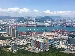
| Kwai Tsing Container Terminals | |||||||||||||
|---|---|---|---|---|---|---|---|---|---|---|---|---|---|
| Traditional Chinese | 葵青貨櫃碼頭 | ||||||||||||
| Simplified Chinese | 葵青货柜码头 | ||||||||||||
| |||||||||||||
Kwai Tsing Container Terminals is the main port facilities in the reclamation along Rambler Channel between Kwai Chung and Tsing Yi Island, Hong Kong. It evolved from four berths of Kwai Chung Container Port (Chinese: 葵涌貨櫃碼頭) completed in the 1970s. It later expanded with two berths in the 1980s. Two additional terminals are added adjoining to Stonecutters Island in the 1990s and was renamed Kwai Chung Container Terminals. In the 2000s, Container Terminal 9 on the Tsing Yi Island was completed and the entire facility was renamed to Kwai Tsing Container Terminals.
It has been the eighth-busiest container port in the world since 2019, just after Shanghai, Singapore, Ningbo-Zhoushan, Shenzhen, Guangzhou, Busan and Qingdao.
History
The Container Committee was appointed by the Governor Sir David Trench on 12 July 1966 to advise the government on the containerisation revolution in cargo handling. In early 1967 the committee declared that Hong Kong had to build the capacity to handle containers, lest the territory's economy would suffer and its port would get bypassed in favour of Singapore and Japan.[1] The committee recommended the site at Kwai Chung. Two former islands on the Rambler Channel, Mong Chau and Pillar Island, were levelled and buried under the port.
While the port was under construction, a main road Kwai Chung Road was built to connect Kwai Chung and Kowloon. Container Port Road, a branch road of Kwai Chung Road, links the port with major industrial areas in Hong Kong.
The first container vessel to call on the new terminal, on 5 September 1972, was the Tokyo Bay.[2]
Thanks to the success of the Kwai Chung Port, Hong Kong overtook New York City in 1986 as the world's second-busiest port.[3][4] In 1987 it seized the title of world's busiest port from Rotterdam.[5] The sunken remains of the hull of the RMS Queen Elizabeth are currently buried beneath the reclaimed land on which the port stands.[6]
Terminals
The port consists of nine container terminals and their operators:
| Terminal name | Abbreviation | Operator | Water depth (metres) |
No. berths | Quay length (metres) |
No. cranes | Area (square metres) |
Capacity (kTEUs) |
Year commissioned |
|---|---|---|---|---|---|---|---|---|---|
Kwai Chung terminals | |||||||||
| Container Terminal 1 | CT1 | Modern Terminals Limited | 16.5 | 1 | 4 | 1972 | |||
| Container Terminal 2 | CT2 | Modern Terminals Limited | 16.5 | 1 | 4 | 1972 | |||
| Container Terminal 3 | CT3 | Dubai Ports International (Hong Kong) Limited | 14 | 1 | 305 | 4 | 167,000 | >1,200 | 1972 |
| Container Terminal 4 | CT4 | Hong Kong International Terminals Limited | ^ | 3 | 8 | 1976 | |||
| Container Terminal 5 | CT5 | Modern Terminals Limited | 16.5 | 1 | 6 | 1988 | |||
| Container Terminal 6 | CT6 | Hong Kong International Terminals Limited | ^ | 3 | 11 | 1989 | |||
| Container Terminal 7 | CT7 | Hong Kong International Terminals Limited | ^ | 4 | 15 | 1990 | |||
| Container Terminal 8 (East) | CT8E | COSCO-HIT Terminals Limited [7] | 15.5 | 2 | 640 | 9 | 300,000 | 1,800 | 1993 |
| Container Terminal 8 (West) | CT8W | Asia Container Terminals Limited | 15.5 | 2 | 740 | 8 | 285,000 | >2,000 | 1993 |
Tsing Yi terminals | |||||||||
| Container Terminal 9 (North) | CT9N | Hong Kong International Terminals Limited | 16.0 | 2 | 700 | 9 | 190,000 | >2,600 (N&S) | 2003 |
| Container Terminal 9 (South) | CT9S | Modern Terminals Limited | 16.5 | 4 | 1,240 | 16 | 490,000 | 2003 | |
^ HIT terminals 4, 6, 7 and 9 (North): 14.2 to 16.0 metre [8]
See also
Notes
- ↑ "Moving cargo in containers: Need for H.K. to keep up with world developments". South China Morning Post. 27 January 1967. p. 1.
- ↑ "Shipping history today in HK's new container port". South China Morning Post. 5 September 1972. p. 29.
- ↑ "A port choked with business". South China Morning Post. 11 June 1987. p. 44.
- ↑ "Hongkong settles in with shipping's big league". South China Morning Post. 7 January 1987. p. 26.
- ↑ Marron, Gerry (13 December 1987). "HK overtakes Rotterdam as the world's busiest port". South China Morning Post. p. 62.
- ↑ "Sea queen to lie below CT9". South China Morning Post. Retrieved 6 August 2011.
- ↑ Joint venture of Hong Kong International Terminals Limited and COSCO Pacific
- ↑ http://www.hkctoa.com/facilities Kwai Tsing Container Port / Port Facilities
22°20′29″N 114°7′29″E / 22.34139°N 114.12472°E