Kulp | |
|---|---|
District and municipality | |
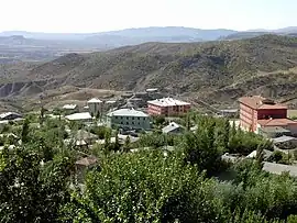
 The city of Kulp | |
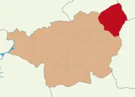
 Map showing Kulp District in Diyarbakır Province | |
 Kulp Location in Turkey | |
| Coordinates: 38°39′51″N 41°00′24″E / 38.66417°N 41.00667°E | |
| Country | Turkey |
| Province | Diyarbakır |
| Area | 1,493 km2 (576 sq mi) |
| Population (2022)[1] | 34,357 |
| • Density | 23/km2 (60/sq mi) |
| Time zone | TRT (UTC+3) |
| Postal code | 21900 |
| Area code | 0412 |
| Website | www |
Kulp (Kurdish: Pasûr,[2] Ottoman Turkish: قولب, romanized: Qulb, central district: Ottoman Turkish: پاصور, romanized: Pasur,[3] Armenian: ԽՈՒԼՓ[4]) is a municipality and district of Diyarbakır Province, Turkey.[5] Its area is 1,493 km2,[6] and its population is 34,357 (2022).[1] It is populated by Kurds.[2]
History
The Kulp region gained importance as a center for the Kurdish chiefdoms in Kulp itself and nearby Zeyrek (to the west).
In 1993 Kulp was under siege by the Workers Party of Kurdistan (PKK). Inhabitants whom the Turkish Government suspected of siding with the PKK were resettled to Diyarbakir.[7]
Politics
In the local elections on the 31 March 2019 Mehmet Fatih Taş of the Peoples' Democratic Party (HDP) was elected Mayor.[8] But he was dismissed by the Ministry of the Interior due to an investigation relating to a terrorist attack. Kaymakam Mustafa Gözlet acts as a trustee instead.[9]
Demographics
Until the 15th century, the area was inhabited by Armenians only. Then nomadic Kurdish tribes started to settle in the area.[4] On the eve of the First World War, more than 5,000 Armenians lived in the kaza, especially in:
- Endzakar (Ընձաքարի, now Ağaçkorur): 140 inhabitants,
- Gazken (now Ağaçlı): 2,000 houses, 100 Armenians,
- Aharonk (now Karabulak, Kulp),
- Ehub (Eyub, now Yaylak),
- Geghervank (Geghervan, Yüklüce in Turkish, merged with Ağaçkorur),
- Shughek (now Argunköy),
- Pasur (now Kulp proper): rural town with 40 Armenian and 40 Kurdish houses.[4][10]
Many Armenians converted to Islam and were linguistically Kurdified. Many of them joined the Kurdish movement.[4]
Culture
Some Armenian cultural features have been preserved such as Armenian dances and Armenian cuisine.[4]
Composition
There are 58 neighbourhoods in Kulp District:[11]
- Ağaçkorur
- Ağaçlı
- Ağıllı
- Akbulak
- Akçasır
- Akdoruk
- Alaca
- Argunköy
- Aşağıelmalı
- Aygün
- Ayhanköy
- Bağcılar
- Baloğlu
- Barın
- Başbuğ
- Bayırköy
- Çağlayan
- Çukurca
- Demirli
- Dolun
- Düzce
- Güleç
- Güllük
- Hamzalı
- İnkaya
- İslamköy
- Kamışlı
- Karaağaç
- Karabulak
- Karaorman
- Karpuzlu
- Kayacık
- Kayahan
- Kaynak
- Koçkar
- Konuklu
- Kurudere
- Merkez Eski
- Merkez Yeni
- Narlıca
- Özbek
- Salkımlı
- Saltukköy
- Taşköprü
- Temren
- Tepecik
- Turgut Özal
- Tuzlaköy
- Üçkuyu
- Ünal
- Uygur
- Uzunova
- Yakıtköy
- Yayıkköy
- Yaylak
- Yeşilköy
- Yuvacık
- Zeyrek
References
- 1 2 "Address-based population registration system (ADNKS) results dated 31 December 2022, Favorite Reports" (XLS). TÜİK. Retrieved 12 July 2023.
- 1 2 Malmîsanij, Mehemed (1989). Pîro; Baran; Şêxbizinî (eds.). "Bazı yörelerde Dımıli ve Kurmanci lehçelerinin köylere göre dağılımı - III -". Berhem (in Turkish). 4: 55. ISSN 1100-0910.
- ↑ Tahir Sezen, Osmanlı Yer Adları (Alfabetik Sırayla), T.C. Başbakanlık Devlet Arşivleri Genel Müdürlüğü, Yayın Nu 21, Ankara, p. 328.
- 1 2 3 4 5 "Kaza Pasur / Khulp' - Խուլփ / Khulb / Kulb / Kulp". Virtual Genocide Memorial. Retrieved 2023-09-17.
- ↑ Büyükşehir İlçe Belediyesi, Turkey Civil Administration Departments Inventory. Retrieved 12 July 2023.
- ↑ "İl ve İlçe Yüz ölçümleri". General Directorate of Mapping. Retrieved 12 July 2023.
- ↑ Jongerden, Joost (2007-05-28). The Settlement Issue in Turkey and the Kurds: An Analysis of Spatial Policies, Modernity and War. BRILL. pp. 261. ISBN 9789047420118.
- ↑ "Diyarbakır Kulp Seçim Sonuçları - 31 Mart 2019 Yerel Seçimleri". www.sabah.com.tr. Retrieved 2019-09-10.
- ↑ "District governor replaces arrested pro-Kurdish mayor in Turkey's southeast". Ahval. Retrieved 2019-11-05.
- ↑ Houshamadyan. "Demography". Houshamadyan. Retrieved 2023-09-17.
- ↑ Mahalle, Turkey Civil Administration Departments Inventory. Retrieved 12 July 2023.
