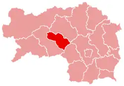
Knittelfeld District
Bezirk Knittelfeld | |
|---|---|
 Knittelfeld District in Styria | |
| Country | Austria |
| State | Styria |
| Number of municipalities | 14 |
| Area | |
| • Total | 578.0 km2 (223.2 sq mi) |
| Population (2001) | |
| • Total | 29,661 |
| • Density | 51/km2 (130/sq mi) |
| Time zone | UTC+1 (CET) |
| • Summer (DST) | UTC+2 (CEST) |
Bezirk Knittelfeld was a district of the state of Styria in Austria. On January 1, 2012 Knittelfeld District and Judenburg District were merged to Murtal District.
Municipalities
Towns (Städte) are indicated in boldface; market towns (Marktgemeinden) in italics; suburbs, hamlets and other subdivisions of a municipality are indicated in small characters.
- Apfelberg
- Landschach
- Feistritz bei Knittelfeld
- Altendorf, Moos
- Flatschach
- Gaal
- Bischoffeld, Gaalgraben, Graden, Ingering II, Puchschachen, Schattenberg
- Großlobming
- Kleinlobming
- Mitterlobming
- Knittelfeld
- Kobenz
- Hautzenbichl, Neuhautzenbichl, Oberfarrach, Raßnitz, Reifersdorf, Unterfarrach
- Rachau
- Glein, Mitterbach
- Sankt Lorenzen bei Knittelfeld
- Fötschach, Gottsbach, Leistach, Pichl, Preg, Preggraben, Ritzendorf, Sankt Benedikten, Schütt, Untermur
- Sankt Marein bei Knittelfeld
- Feistritzgraben, Fentsch, Fressenberg, Greith, Hof, Laas, Mitterfeld, Prankh, Sankt Martha, Wasserleith, Kniepaß
- Sankt Margarethen bei Knittelfeld
- Gobernitz, Kroisbach, Obermur, Ugendorf
- Seckau
- Dürnberg, Seckau, Neuhofen, Sonnwenddorf
- Spielberg
- Einhörn, Ingering I, Laing, Lind, Maßweg, Pausendorf, Sachendorf, Schönberg, Spielberg, Weyern
This article is issued from Wikipedia. The text is licensed under Creative Commons - Attribution - Sharealike. Additional terms may apply for the media files.