Kitsuki
杵築市 | |
|---|---|
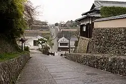
 Kitsuki castle town | |
 Flag  Chapter | |
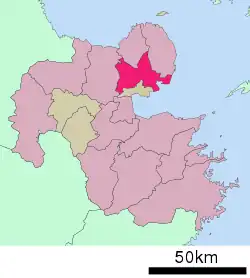
Location of Kitsuki in Ōita Prefecture | |
 | |
 Kitsuki Location in Japan | |
| Coordinates: 33°25′01″N 131°36′58″E / 33.41694°N 131.61611°E | |
| Country | Japan |
| Region | Kyushu |
| Prefecture | Ōita |
| Government | |
| • Mayor | Kyosuke Yasaka (since June 2006) |
| Area | |
| • Total | 280.08 km2 (108.14 sq mi) |
| Population (October 31, 2023) | |
| • Total | 26,761 |
| • Density | 96/km2 (250/sq mi) |
| Time zone | UTC+09:00 (JST) |
| City hall address | 377-1 Oji Kitsuki, Kitsuki-shi, Oita-ken 873-0001 |
| Climate | Cfa |
| Website | Official website |
| Symbols | |
| Flower | Calanthe discolor |
| Tree | Prunus mume |


Kitsuki (杵築市, Kitsuki-shi) is a city located in Ōita Prefecture, Japan. As of 31 October 2023, the city had an estimated population of 26,761 in 13199 households, and a population density of 96 persons per km². [1] The total area of the city is 280.08 km2 (108.14 sq mi).
Geography
Kitsuki is located in east-central Ōita Prefecture at the southern tip of the Kunisaki Peninsula, across Beppu Bay from the prefectural capital at Ōita City. By land, it is approximately 35 kilometers from the center of Ōita City. The northern and western parts of the city are mountainous. Tateishi Pass, adjacent to Usa City, is the border between the former Bungo Province and Buzen Province.
Neighboring municipalities
Climate
Kitsuki has a humid subtropical climate (Köppen climate classification Cfa) with hot summers and cool winters. Precipitation is significant throughout the year, but is somewhat lower in winter. The average annual temperature in Kitsuki is 15.8 °C (60.4 °F). The average annual rainfall is 1,524.6 mm (60.02 in) with June as the wettest month. The temperatures are highest on average in August, at around 26.8 °C (80.2 °F), and lowest in January, at around 5.3 °C (41.5 °F).[2] The highest temperature ever recorded in Kitsuki was 37.4 °C (99.3 °F) on 18 August 2020; the coldest temperature ever recorded was −6.8 °C (19.8 °F) on 15 January 1985.[3]
| Climate data for Kitsuki (1991−2020 normals, extremes 1978−present) | |||||||||||||
|---|---|---|---|---|---|---|---|---|---|---|---|---|---|
| Month | Jan | Feb | Mar | Apr | May | Jun | Jul | Aug | Sep | Oct | Nov | Dec | Year |
| Record high °C (°F) | 19.4 (66.9) |
24.0 (75.2) |
28.8 (83.8) |
30.4 (86.7) |
33.0 (91.4) |
35.1 (95.2) |
36.7 (98.1) |
37.4 (99.3) |
35.6 (96.1) |
32.3 (90.1) |
28.3 (82.9) |
24.2 (75.6) |
37.4 (99.3) |
| Mean daily maximum °C (°F) | 10.2 (50.4) |
11.0 (51.8) |
14.2 (57.6) |
19.0 (66.2) |
23.3 (73.9) |
25.9 (78.6) |
29.7 (85.5) |
31.0 (87.8) |
27.9 (82.2) |
23.2 (73.8) |
17.8 (64.0) |
12.5 (54.5) |
20.5 (68.9) |
| Daily mean °C (°F) | 5.3 (41.5) |
6.0 (42.8) |
9.1 (48.4) |
13.8 (56.8) |
18.3 (64.9) |
21.8 (71.2) |
25.8 (78.4) |
26.8 (80.2) |
23.6 (74.5) |
18.3 (64.9) |
12.7 (54.9) |
7.5 (45.5) |
15.8 (60.3) |
| Mean daily minimum °C (°F) | 0.7 (33.3) |
1.1 (34.0) |
3.9 (39.0) |
8.3 (46.9) |
13.3 (55.9) |
18.3 (64.9) |
22.7 (72.9) |
23.5 (74.3) |
20.0 (68.0) |
13.8 (56.8) |
7.8 (46.0) |
2.7 (36.9) |
11.3 (52.4) |
| Record low °C (°F) | −6.8 (19.8) |
−6.7 (19.9) |
−4.9 (23.2) |
−2.3 (27.9) |
2.1 (35.8) |
9.5 (49.1) |
14.9 (58.8) |
17.1 (62.8) |
9.9 (49.8) |
2.2 (36.0) |
−1.9 (28.6) |
−5.0 (23.0) |
−6.8 (19.8) |
| Average precipitation mm (inches) | 47.1 (1.85) |
59.9 (2.36) |
98.0 (3.86) |
118.0 (4.65) |
133.5 (5.26) |
287.7 (11.33) |
255.3 (10.05) |
135.4 (5.33) |
184.7 (7.27) |
107.7 (4.24) |
63.4 (2.50) |
49.2 (1.94) |
1,524.6 (60.02) |
| Average precipitation days (≥ 1.0 mm) | 6.7 | 7.9 | 10.0 | 9.6 | 9.1 | 13.2 | 12.1 | 9.3 | 9.8 | 6.8 | 6.5 | 6.5 | 107.5 |
| Mean monthly sunshine hours | 145.5 | 142.7 | 175.0 | 192.5 | 201.9 | 146.5 | 183.0 | 212.3 | 158.8 | 168.7 | 145.4 | 144.3 | 2,024.1 |
| Source: Japan Meteorological Agency[3][2] | |||||||||||||
Demographics
Per Japanese census data, the population of Kitsuki in 2020 is 27,999 people.[4] Kitsuki has been conducting censuses since 1950.
| Year | Pop. | ±% |
|---|---|---|
| 1950 | 52,414 | — |
| 1955 | 50,544 | −3.6% |
| 1960 | 47,543 | −5.9% |
| 1965 | 42,617 | −10.4% |
| 1970 | 38,504 | −9.7% |
| 1975 | 36,299 | −5.7% |
| 1980 | 35,066 | −3.4% |
| 1985 | 34,816 | −0.7% |
| 1990 | 34,095 | −2.1% |
| 1995 | 33,370 | −2.1% |
| 2000 | 33,363 | −0.0% |
| 2005 | 33,567 | +0.6% |
| 2010 | 32,087 | −4.4% |
| 2015 | 30,185 | −5.9% |
| 2020 | 27,999 | −7.2% |
| Kitsuki population statistics[4] | ||
History
The area of Kitsuki was part of ancient Bungo Province. During the Edo period it was mostly under control of Kitsuki Domain and was ruled by a cadet branch of the Matsudaira clan, with smaller areas under control of Hiji Domain. After the Meiji restoration, the town of Kitsuki within Hayami District, Ōita was established on May 1, 1889 with the creation of the modern municipalities system. On April 1, 1955 Kitsuki merged with the villages of Yasaka, Kita-Kitsuki and, Nakarie and was raised to city status. On October 1, 2005 Kitsuki merged with the town of Yamaka from Hayami District and the village of Ota from Nishikunisaki District, Ōita
Government
Kitsuki has a mayor-council form of government with a directly elected mayor and a unicameral city council of 18 members. Kitsuki contributes one member to the Ōita Prefectural Assembly. In terms of national politics, the city is part of the Ōita 3rd district of the lower house of the Diet of Japan.
Economy
Agriculture, forestry and fisheries are the main industries, but due to its favorable location between Oita Airport and Ōita City/Beppu City, advanced technology industries, such as semiconductor production are now established.
Education
Kitsuki has 15 public elementary schools and three public junior high schools operated by the city government and one public high school operated by the Ōita Prefectural Board of Education.
Transportation
Railways
Highways
Local attractions
- Kitsuki Castle
Notable people from Kitsuki
- Asada Goryu, physician and astronomer
- Teikichi Hori, admiral in the Imperial Japanese Navy
- Soemu Toyoda, admiral in the Imperial Japanese Navy
References
- ↑ "Kitsuki City official statistics" (in Japanese). Japan.
- 1 2 気象庁 / 平年値(年・月ごとの値). JMA. Retrieved April 28, 2022.
- 1 2 観測史上1~10位の値(年間を通じての値). JMA. Retrieved April 28, 2022.
- 1 2 Kitsuki population statistics
External links
- Kitsuki City official website (in Japanese)