Kimotsuki
肝付町 | |
|---|---|
Town | |
 Flag  Emblem | |
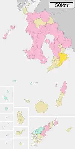
 Location of Kimotsuki in Kagoshima Prefecture | |
 Kimotsuki Location in Japan | |
| Coordinates: 31°16′45″N 130°59′33″E / 31.27917°N 130.99250°E | |
| Country | Japan |
| Region | Kyushu |
| Prefecture | Kagoshima Prefecture |
| District | Kimotsuki |
| Government | |
| • Mayor | Nagano Kazuyuki |
| Area | |
| • Total | 308.12 km2 (118.97 sq mi) |
| Population (October 2019) | |
| • Total | 15,169 |
| • Density | 49/km2 (130/sq mi) |
| Time zone | UTC+09:00 (JST) |
| City hall address | 98 Nitomi Kimotsuki-chō, Kimotsuki-gun, Kagoshima-ken 893-1207 |
| Climate | Cfa |
| Website | kimotsuki-town |
| Symbols | |
| Flower | Chrysanthemum |
| Tree | Camphor |
Kimotsuki (肝付町, Kimotsuki-chō) is a town in Kimotsuki District. It is located in the eastern part of the Ōsumi Peninsula in Kagoshima Prefecture, Japan.
The town was formed on July 1, 2005 from the merger of the towns of Kōyama and Uchinoura, both from Kimotsuki District. As of October 2019, the town has an estimated population of 15,169. The total area is 308.12 km2.
The Uchinoura Space Center is located in this town.
Geography
Climate
Kimotsuki has a humid subtropical climate (Köppen climate classification Cfa) with hot summers and mild winters. Precipitation is significant throughout the year, and is heavier in summer, especially the months of June and July. The average annual temperature in Kimotsuki is 17.5 °C (63.5 °F). The average annual rainfall is 2,747.6 mm (108.17 in) with June as the wettest month. The temperatures are highest on average in August, at around 27.2 °C (81.0 °F), and lowest in January, at around 7.6 °C (45.7 °F).[1] Its record high is 38.5 °C (101.3 °F), reached on 18 August 2020, and its record low is −6.4 °C (20.5 °F), reached on 25 January 2016.[2]
| Climate data for Kimotsuki (1991−2020 normals, extremes 1977−present) | |||||||||||||
|---|---|---|---|---|---|---|---|---|---|---|---|---|---|
| Month | Jan | Feb | Mar | Apr | May | Jun | Jul | Aug | Sep | Oct | Nov | Dec | Year |
| Record high °C (°F) | 24.3 (75.7) |
24.3 (75.7) |
27.3 (81.1) |
29.7 (85.5) |
34.3 (93.7) |
34.2 (93.6) |
36.1 (97.0) |
38.5 (101.3) |
35.7 (96.3) |
34.1 (93.4) |
29.3 (84.7) |
25.1 (77.2) |
38.5 (101.3) |
| Mean daily maximum °C (°F) | 13.1 (55.6) |
14.5 (58.1) |
17.4 (63.3) |
21.8 (71.2) |
25.3 (77.5) |
27.0 (80.6) |
31.4 (88.5) |
31.9 (89.4) |
29.4 (84.9) |
25.1 (77.2) |
20.1 (68.2) |
15.2 (59.4) |
22.7 (72.8) |
| Daily mean °C (°F) | 7.6 (45.7) |
8.8 (47.8) |
11.8 (53.2) |
16.2 (61.2) |
20.1 (68.2) |
23.0 (73.4) |
26.9 (80.4) |
27.2 (81.0) |
24.5 (76.1) |
19.7 (67.5) |
14.5 (58.1) |
9.4 (48.9) |
17.5 (63.5) |
| Mean daily minimum °C (°F) | 2.4 (36.3) |
3.4 (38.1) |
6.5 (43.7) |
10.9 (51.6) |
15.4 (59.7) |
19.7 (67.5) |
23.5 (74.3) |
23.8 (74.8) |
20.8 (69.4) |
15.1 (59.2) |
9.4 (48.9) |
4.0 (39.2) |
12.9 (55.2) |
| Record low °C (°F) | −6.4 (20.5) |
−6.0 (21.2) |
−3.5 (25.7) |
0.6 (33.1) |
5.3 (41.5) |
11.2 (52.2) |
15.3 (59.5) |
17.2 (63.0) |
10.6 (51.1) |
2.5 (36.5) |
−1.8 (28.8) |
−4.9 (23.2) |
−6.4 (20.5) |
| Average precipitation mm (inches) | 81.9 (3.22) |
115.6 (4.55) |
167.0 (6.57) |
193.5 (7.62) |
214.3 (8.44) |
579.5 (22.81) |
384.6 (15.14) |
294.3 (11.59) |
352.6 (13.88) |
169.7 (6.68) |
112.1 (4.41) |
82.6 (3.25) |
2,747.6 (108.17) |
| Average precipitation days (≥ 1.0 mm) | 8.2 | 9.0 | 12.2 | 11.0 | 10.8 | 17.4 | 12.5 | 13.2 | 12.1 | 8.2 | 8.1 | 7.4 | 130.1 |
| Mean monthly sunshine hours | 138.3 | 141.2 | 160.9 | 168.7 | 161.7 | 96.7 | 177.0 | 191.1 | 155.4 | 170.2 | 151.2 | 140.8 | 1,852.9 |
| Source: Japan Meteorological Agency[2][1] | |||||||||||||
| Climate data for Uchinoura, Kimotsuki (1991−2020 normals, extremes 1977−present) | |||||||||||||
|---|---|---|---|---|---|---|---|---|---|---|---|---|---|
| Month | Jan | Feb | Mar | Apr | May | Jun | Jul | Aug | Sep | Oct | Nov | Dec | Year |
| Record high °C (°F) | 23.8 (74.8) |
24.4 (75.9) |
27.5 (81.5) |
29.3 (84.7) |
33.1 (91.6) |
33.9 (93.0) |
37.2 (99.0) |
36.9 (98.4) |
34.6 (94.3) |
33.5 (92.3) |
31.2 (88.2) |
24.6 (76.3) |
37.2 (99.0) |
| Mean daily maximum °C (°F) | 13.6 (56.5) |
14.8 (58.6) |
17.6 (63.7) |
21.7 (71.1) |
25.2 (77.4) |
27.3 (81.1) |
31.5 (88.7) |
32.0 (89.6) |
29.5 (85.1) |
25.4 (77.7) |
20.6 (69.1) |
15.7 (60.3) |
22.9 (73.2) |
| Daily mean °C (°F) | 8.7 (47.7) |
9.8 (49.6) |
12.6 (54.7) |
16.6 (61.9) |
20.2 (68.4) |
23.2 (73.8) |
26.9 (80.4) |
27.3 (81.1) |
24.9 (76.8) |
20.4 (68.7) |
15.4 (59.7) |
10.6 (51.1) |
18.1 (64.5) |
| Mean daily minimum °C (°F) | 3.8 (38.8) |
4.8 (40.6) |
7.7 (45.9) |
11.5 (52.7) |
15.5 (59.9) |
19.7 (67.5) |
23.2 (73.8) |
23.8 (74.8) |
21.3 (70.3) |
16.1 (61.0) |
10.7 (51.3) |
5.6 (42.1) |
13.6 (56.6) |
| Record low °C (°F) | −5.2 (22.6) |
−5.3 (22.5) |
−2.4 (27.7) |
1.8 (35.2) |
4.6 (40.3) |
10.6 (51.1) |
14.7 (58.5) |
17.9 (64.2) |
12.3 (54.1) |
5.6 (42.1) |
0.4 (32.7) |
−2.8 (27.0) |
−5.3 (22.5) |
| Average precipitation mm (inches) | 116.4 (4.58) |
175.3 (6.90) |
260.2 (10.24) |
323.4 (12.73) |
323.3 (12.73) |
666.6 (26.24) |
368.2 (14.50) |
244.0 (9.61) |
352.1 (13.86) |
186.6 (7.35) |
167.2 (6.58) |
115.3 (4.54) |
3,233.5 (127.30) |
| Average precipitation days (≥ 1.0 mm) | 8.1 | 9.4 | 12.7 | 11.1 | 11.6 | 17.6 | 12.0 | 13.4 | 13.2 | 9.1 | 8.6 | 7.8 | 134.6 |
| Mean monthly sunshine hours | 140.7 | 131.9 | 153.6 | 162.8 | 165.2 | 96.6 | 181.2 | 184.5 | 143.5 | 157.9 | 145.7 | 138.6 | 1,802 |
| Source: Japan Meteorological Agency[3][4] | |||||||||||||
Demographics
Per Japanese census data, the population of Kimotsuki in 2020 is 14,227 people.[5] Kimotsuki has been conducting censuses since 1920. The town's population peaked in the 1950s and has been slowly declining since then, with no sign of a recovery until 2020.
| Year | Pop. | ±% |
|---|---|---|
| 1920 | 20,967 | — |
| 1925 | 22,994 | +9.7% |
| 1930 | 25,529 | +11.0% |
| 1935 | 26,685 | +4.5% |
| 1940 | 26,875 | +0.7% |
| 1945 | 32,402 | +20.6% |
| 1950 | 33,813 | +4.4% |
| 1955 | 34,372 | +1.7% |
| 1960 | 32,553 | −5.3% |
| 1965 | 29,619 | −9.0% |
| 1970 | 25,433 | −14.1% |
| 1975 | 23,892 | −6.1% |
| 1980 | 23,361 | −2.2% |
| 1985 | 22,955 | −1.7% |
| 1990 | 21,542 | −6.2% |
| 1995 | 20,317 | −5.7% |
| 2000 | 19,523 | −3.9% |
| 2005 | 18,307 | −6.2% |
| 2010 | 17,156 | −6.3% |
| 2015 | 15,664 | −8.7% |
| 2020 | 14,227 | −9.2% |
| Kimotsuki population statistics[5] | ||
Points of Interest
- Nikaido House (National Important Cultural Property)
- Tsukazaki Kofun Cluster (National Historic Site)
- Trace of Koyama Castle (National Historic Site)
- Shijukusho Shrine
- Uchinoura Space Center
- Todoro Falls
- Osumi Nanbu Prefectural Natural Park
- Yabusame Public Park
Culture
Events and festivals
- Doya Doya Sa (January 7th)
- Staff and sickle dances (March)
- Nagoshidon (mid-August)
- Honmachi Hachigatsu Odori (Fourth Saturday of August, every even year)
- Eggane Festival (September or October)
- Yabusame Festival (Third Sunday of October)
- Uchinoura Galaxy Marathon, commemorating the formation of the Republic of Uchinoura and the Galaxy Federation (November)
Mascots
Kimotsuki has two town mascots (see yuru-chara) created by the Kimotsuki Tourism Association. Both wear purple outfits based on the traditional costume of the Yabusame Festival archer and have satellite heads. They generally make appearances at town sanctioned events.
Sister City Relations
The Galaxy Federation
Before the merger, the town of Uchinoura was a part of the Galaxy Federation, a chain of friendship cities that each house a JAXA space center. It joined the federation as a founding member on November 8, 1987 and received the name the Republic of Uchinoura. The friendship city relations were still retained when Uchinoura merged with Koyama to become Kimotsuki town, and it is now called the Republic of Uchinoura Kimotsuki within the federation. The most recent member of the federation, the city of Kakuda in Miyagi Prefecture, joined on April 2, 2016.
Space Brother Cities
Kimotsuki and the town of Minamitane, home to Tanegashima's JAXA space center, signed the “Space Brother Cities Declaration” on July 3, 2013. The naming comes from the manga and anime series Space Brothers, and the official document even features an illustration of the two main characters, the Nanba brothers.
References
- 1 2 気象庁 / 平年値(年・月ごとの値). JMA. Retrieved March 27, 2022.
- 1 2 観測史上1~10位の値(年間を通じての値). JMA. Retrieved March 27, 2022.
- ↑ 観測史上1~10位の値(年間を通じての値). JMA. Retrieved March 28, 2022.
- ↑ 気象庁 / 平年値(年・月ごとの値). JMA. Retrieved March 28, 2022.
- 1 2 Kimotsuki population statistics
- ↑ "ゆるキャラグランプリ公式サイト".
- ↑ "はやぶさめくん|イメキャラブック".
External links
 Media related to Kimotsuki, Kagoshima at Wikimedia Commons
- Kimotsuki official website (in Japanese)
- Kimotsuki Wikipedia page (in Japanese)