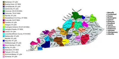
Map of the 25 core-based statistical areas in Kentucky.
An enlargeable map of the 25 core-based statistical areas in Kentucky.[1]

The United States Commonwealth of Kentucky currently has 31 statistical areas that have been delineated by the Office of Management and Budget (OMB). On March 6, 2020, the OMB delineated six combined statistical areas, nine metropolitan statistical areas, and 16 micropolitan statistical areas in Kentucky.[1]

Statistical areas

The Office of Management and Budget (OMB) has designated more than 1,000 statistical areas for the United States and Puerto Rico.[2] These statistical areas are important geographic delineations of population clusters used by the OMB, the United States Census Bureau, planning organizations, and federal, state, and local government entities.

The OMB defines a core-based statistical area (commonly referred to as a CBSA) as "a statistical geographic entity consisting of the county or counties (or county-equivalents) associated with at least one core[lower-alpha 1] of at least 10,000 population, plus adjacent counties having a high degree of social and economic integration with the core as measured through commuting ties with the counties containing the core."[2] The OMB further divides core-based statistical areas into metropolitan statistical areas (MSAs) that have "a population of at least 50,000" and micropolitan statistical areas (μSAs) that have "a population of at least 10,000, but less than 50,000."[2]

The OMB defines a combined statistical area (CSA) as "a geographic entity consisting of two or more adjacent core-based statistical areas with employment interchange measures[lower-alpha 2] of at least 15%."[2] The primary statistical areas (PSAs) include all combined statistical areas and any core-based statistical area that is not a constituent of a combined statistical area.

Table

The table below describes the 31 United States statistical areas and 120 counties of the Commonwealth of Kentucky with the following information:[3]

  1. The combined statistical area (CSA) as designated by the OMB.[1]
  2. The CSA population according to 2019 US Census Bureau population estimates.[4]
  3. The core based statistical area (CBSA)[2] as designated by the OMB.[1]
  4. The CBSA population according to 2019 US Census Bureau population estimates [4]
  5. The county name
  6. The county population according to 2019 US Census Bureau population estimates [4]
The 31 United States statistical areas and 120 counties of the Commonwealth of Kentucky

Combined Statistical Area 2019 Population Core Based Statistical Area 2019 Population County 2019 Population
Louisville/Jefferson County–-Elizabethtown–-Bardstown, KY-IN CSA 1,489,142
1,199,894
Louisville/Jefferson County, KY-IN MSA 1,265,108
999,733
Jefferson County, Kentucky 766,757
Clark County, Indiana 118,302
Bullitt County, Kentucky 81,676
Floyd County, Indiana 78,522
Oldham County, Kentucky 66,799
Shelby County, Kentucky 49,024
Harrison County, Indiana 40,515
Washington County, Indiana 28,036
Spencer County, Kentucky 19,351
Henry County, Kentucky 16,126
Elizabethtown-Fort Knox, KY MSA 153,928 Hardin County, Kentucky 110,958
Meade County, Kentucky 28,572
LaRue County, Kentucky 14,398
Bardstown, KY μSA 46,233 Nelson County, Kentucky 46,233
Scottsburg, IN μSA 23,873 Scott County, Indiana 23,873
Lexington-Fayette--Richmond--Frankfort, KY CSA 745,033 Lexington-Fayette, KY MSA 517,056 Fayette County, Kentucky 323,152
Scott County, Kentucky 57,004
Jessamine County, Kentucky 54,115
Clark County, Kentucky 36,263
Woodford County, Kentucky 26,734
Bourbon County, Kentucky 19,788
Richmond-Berea, KY μSA 107,093 Madison County, Kentucky 92,987
Estill County, Kentucky 14,106
Frankfort, KY μSA 73,738 Franklin County, Kentucky 50,991
Anderson County, Kentucky 22,747
Mount Sterling, KY μSA 47,146 Montgomery County, Kentucky 28,157
Bath County, Kentucky 12,500
Menifee County, Kentucky 6,489
Cincinnati-Wilmington-Maysville, OH-KY-IN CSA 2,280,246
468,064
Cincinnati, OH-KY-IN MSA 2,221,208
450,994
Hamilton County, Ohio 817,473
Butler County, Ohio 383,134
Warren County, Ohio 234,602
Clermont County, Ohio 206,428
Kenton County, Kentucky 166,998
Boone County, Kentucky 133,581
Campbell County, Kentucky 93,584
Dearborn County, Indiana 49,458
Brown County, Ohio 43,432
Grant County, Kentucky 25,069
Franklin County, Indiana 22,758
Pendleton County, Kentucky 14,590
Gallatin County, Kentucky 8,869
Bracken County, Kentucky 8,303
Union County, Indiana 7,054
Ohio County, Indiana 5,875
Wilmington, OH μSA 41,968 Clinton County, Ohio 41,968
Maysville, KY μSA 17,070 Mason County, Kentucky 17,070
Bowling Green-Glasgow, KY CSA 233,560 Bowling Green, KY MSA 179,240 Warren County, Kentucky 132,896
Allen County, Kentucky 21,315
Butler County, Kentucky 12,879
Edmonson County, Kentucky 12,150
Glasgow, KY μSA 54,320 Barren County, Kentucky 44,249
Metcalfe County, Kentucky 10,071
Paducah-Mayfield, KY-IL CSA 133,538
119,766
Paducah, KY-IL μSA 96,272
82,500
McCracken County, Kentucky 65,418
Massac County, Illinois 13,772
Livingston County, Kentucky 9,194
Ballard County, Kentucky 7,688
Mayfield, KY μSA 37,266 Graves County, Kentucky 37,266
Charleston-Huntington-Ashland, WV-OH-KY CSA 776,694
108,613
Huntington-Ashland, WV-KY-OH MSA 355,873
108,613
Cabell County, West Virginia 91,945
Lawrence County, Ohio 59,463
Putnam County, West Virginia 56,450
Boyd County, Kentucky 46,718
Wayne County, West Virginia 39,402
Greenup County, Kentucky 35,098
Carter County, Kentucky 26,797
Charleston, WV MSA 257,074 Kanawha County, West Virginia 178,124
Jackson County, West Virginia 28,576
Boone County, West Virginia 21,457
Lincoln County, West Virginia 20,409
Clay County, West Virginia 8,508
Portsmouth, OH μSA 75,314 Scioto County, Ohio 75,314
Point Pleasant, WV-OH μSA 56,414 Gallia County, Ohio 29,898
Mason County, West Virginia 26,516
Mount Gay-Shamrock μSA 32,019 Logan County, West Virginia 32,019
none Owensboro, KY MSA 119,440 Daviess County, Kentucky 101,511
McLean County, Kentucky 9,207
Hancock County, Kentucky 8,722
Clarksville, TN-KY MSA 307,820
85,112
Montgomery County, Tennessee 208,993
Christian County, Kentucky 70,461
Trigg County, Kentucky 14,651
Stewart County, Tennessee 13,715
Evansville, IN-KY MSA 315,086
58,152
Vanderburgh County, Indiana 181,451
Warrick County, Indiana 62,998
Henderson County, Kentucky 45,210
Posey County, Indiana 25,427
Webster County, Kentucky 12,942
London, KY μSA 148,123 Laurel County, Kentucky 60,813
Whitley County, Kentucky 36,264
Knox County, Kentucky 31,145
Clay County, Kentucky 19,901
Somerset, KY μSA 64,979 Pulaski County, Kentucky 64,979
Danville, KY μSA 54,609 Boyle County, Kentucky 30,060
Lincoln County, Kentucky 24,549
Madisonville, KY μSA 44,686 Hopkins County, Kentucky 44,686
Murray, KY μSA 39,001 Calloway County, Kentucky 39,001
Campbellsville, KY μSA 36,710 Taylor County, Kentucky 25,769
Green County, Kentucky 10,941
Central City, KY μSA 30,622 Muhlenberg County, Kentucky 30,622
Middlesborough, KY μSA 26,032 Bell County, Kentucky 26,032
none Pike County, Kentucky 57,876
Floyd County, Kentucky 35,589
Marshall County, Kentucky 31,100
Logan County, Kentucky 27,102
Grayson County, Kentucky 26,427
Harlan County, Kentucky 26,010
Perry County, Kentucky 25,758
Rowan County, Kentucky 24,460
Ohio County, Kentucky 23,994
Johnson County, Kentucky 22,188
Mercer County, Kentucky 21,933
Letcher County, Kentucky 21,553
Breckinridge County, Kentucky 20,477
Wayne County, Kentucky 20,333
Marion County, Kentucky 19,273
Adair County, Kentucky 19,202
Hart County, Kentucky 19,035
Harrison County, Kentucky 18,886
Simpson County, Kentucky 18,572
Russell County, Kentucky 17,923
Garrard County, Kentucky 17,666
McCreary County, Kentucky 17,231
Rockcastle County, Kentucky 16,695
Casey County, Kentucky 16,159
Lawrence County, Kentucky 15,317
Knott County, Kentucky 14,806
Fleming County, Kentucky 14,581
Union County, Kentucky 14,381
Jackson County, Kentucky 13,329
Morgan County, Kentucky 13,309
Lewis County, Kentucky 13,275
Caldwell County, Kentucky 12,747
Breathitt County, Kentucky 12,630
Powell County, Kentucky 12,359
Todd County, Kentucky 12,294
Magoffin County, Kentucky 12,161
Washington County, Kentucky 12,095
Martin County, Kentucky 11,195
Owen County, Kentucky 10,901
Monroe County, Kentucky 10,650
Carroll County, Kentucky 10,631
Clinton County, Kentucky 10,218
Leslie County, Kentucky 9,877
Crittenden County, Kentucky 8,806
Trimble County, Kentucky 8,471
Lyon County, Kentucky 8,210
Elliott County, Kentucky 7,517
Lee County, Kentucky 7,403
Nicholas County, Kentucky 7,269
Wolfe County, Kentucky 7,157
Cumberland County, Kentucky 6,614
Fulton County, Kentucky 5,969
Carlisle County, Kentucky 4,760
Owsley County, Kentucky 4,415
Hickman County, Kentucky 4,380
Robertson County, Kentucky 2,108
Commonwealth of Kentucky 4,467,673

See also

Notes

  1. The OMB defines a core as "a densely settled concentration of population, comprising an Urban Area (of 10,000 or more population) delineated by the Census Bureau, around which a core-based statistical area is delineated."[2]
  2. The OMB defines the employment interchange measure as "the sum of the percentage of workers living in the smaller entity who work in the larger entity plus the percentage of employment in the smaller entity that is accounted for by workers who reside in the larger entity."[2]

References

  1. 1 2 3 4 Revised Delineations of Metropolitan Statistical Areas, Micropolitan Statistical Areas, and Combined Statistical Areas, and Guidance on Uses of the Delineations of These Areas (March 6, 2020). "0MB BULLETIN NO. 20-01" (PDF). Office of Management and Budget. Retrieved December 13, 2021.{{cite web}}: CS1 maint: multiple names: authors list (link)
  2. 1 2 3 4 5 6 7 "2020 Standards for Delineating Core Based Statistical Areas". Office of Management and Budget. July 16, 2021. Retrieved December 13, 2021.
  3. An out-of-state area and its population are displayed in green. An area that extends into more than one state is displayed in teal. A teal population number over a black population number show the total population versus the in-state population.
  4. 1 2 3 "Annual Estimates of the Resident Population for Counties in the United States: April 1, 2010 to July 1, 2019". United States Census Bureau, Population Division. April 2020. Retrieved April 9, 2020.

37°32′05″N 85°18′08″W / 37.5347°N 85.3021°W / 37.5347; -85.3021 (Commonwealth of Kentucky)

This article is issued from Wikipedia. The text is licensed under Creative Commons - Attribution - Sharealike. Additional terms may apply for the media files.