Gloucester | |
|---|---|
Former municipality | |
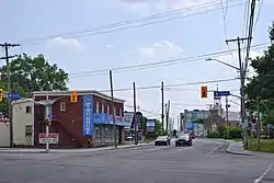
 The Cyrville neighbourhood in the former city of Gloucester. | |
 Flag | |
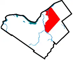
 The limits of the former City of Gloucester within the current City of Ottawa | |
| Coordinates: 45°26′07″N 75°36′33″W / 45.435277777778°N 75.609166666667°W | |
| Country | Canada |
| Province | Ontario |
| Municipality | Ottawa |
| Established | 1792 |
| Incorporated | 1850 (township) 1981 (city) |
| Amalgamated | 2001 |
| Government | |
| • City councillors | George Darouze Jessica Bradley Laura Dudas Steve Desroches Tim Tierney |
| • Members of Parliament | Mona Fortier David McGuinty |
| • Members of Provincial Parliament | Lucille Collard John Fraser |
| Area | |
| • Total | 298.5 km2 (115.3 sq mi) |
| Population (2021) | |
| • Total | 150,012 |
| • Density | 500/km2 (1,300/sq mi) |
| Time zone | UTC−5 (Eastern (EST)) |
| • Summer (DST) | UTC−4 (EDT) |
| Area code(s) | 613, 343, 753 |
Gloucester (/ˈɡlɒstər/ GLOST-ər) is a former municipality and now geographic area of Ottawa, Ontario, Canada. Located east of Ottawa's inner core, it was an independent city until amalgamated with the Regional Municipality of Ottawa–Carleton in 2001 to become the new city of Ottawa. The population of Gloucester is about 150,012 people (2021 Census).
History
Gloucester, originally known as Township B, was established in 1792. The first settler in the township was Braddish Billings in what is now the Billings Bridge area of Ottawa. In 1800, the township became part of Russell County, and later Carleton County in 1838. In 1850, the area was incorporated as Gloucester Township, named after Prince William Frederick, Duke of Gloucester and Edinburgh.[1] Over the years, parts of Gloucester Township were annexed by the expanding city of Ottawa. Gloucester was incorporated as a city in 1981 and became part of the amalgamated city of Ottawa in 2001.
Town Halls
1872—1962: Bank Street in Billings Bridge
1962—1996: Bank Street in Leitrim
1996—2001: Telesat Court in Pineview
Reeves
| Reeves of Gloucester Township |
|
Mayors
- 1981-1982 Elizabeth Stewart
- 1982-1984 Fred G. Barrett
- 1984-1985 Mitch Owens
- 1985-1991 Harry Allen
- 1991-2001 Claudette Cain
Demographics

| Year | Pop. | ±% |
|---|---|---|
| 1981 | 72,090 | — |
| 1986 | 89,810 | +24.6% |
| 1991 | 101,677 | +13.2% |
| 1996 | 104,022 | +2.3% |
| 2001 | 110,264 | +6.0% |
| 2006 | 114,604 | +3.9% |
| 2011 | 116,282 | +1.5% |
| 2016 | 122,972 | +5.8% |
| 2021 | 150,012 | +22.0% |
| Neighbourhood | Population (2021) | Population (2016) | Population (2011) | Population (2006) | Area (km2.) | Density (per km2.) | Census Tracts |
|---|---|---|---|---|---|---|---|
| Beacon Hill North | 9,342 | 9,177 | 9,007 | 8,819 | 5.434 | 1719.176 | 5050120.03, 5050120.02 |
| Beacon Hill South | 7,746 | 7,319 | 7,312 | 6,953 | 2.258 | 3430.469 | 5050121.01, 5050121.02 |
| Blackburn Hamlet | 8,173 | 8,167 | 8,237 | 8,527 | 2.413 | 3387.070 | 5050125.01, 5050125.02 |
| Blossom Park | 14,621 | 14,190 | 14,060 | 12,361 | 6.193 | 2360.891 | 5050123.01, 5050123.03, 5050123.04 |
| Bradley Estates | 5,385 | 4.397 | 1224.81 | 5050125.11 | |||
| Chapel Hill | 8,124 | 8,293 | 8,521 | 8,566 | 3.398 | 2390.818 | 5050125.07, 5050125.04 |
| Chapel Hill South-Trailsedge | 8,441 | 5.509 | 1532.359 | 5050125.10 | |||
| Chateau Neuf | 8,278 | 8,407 | 8,579 | 8,724 | 2.051 | 4036.080 | 5050125.08, 5050125.09 |
| Convent Glen | 6,499 | 6,456 | 6,572 | 6,568 | 4.006 | 1622.317 | 5050124.04, 5050124.01 |
| Cyrville-Carson Grove | 9,278 | 8,532 | 8,662 | 8,173 | 3.353 | 2767.074 | 5050122.01, 5050122.03 |
| Elizabeth Park-Kemp Park | 4,007 | 3,410 | 3,902 | 3,548 | 19.687 | 203.535 | 5050127.00 |
| Hiawatha Park | 4,779 | 4,841 | 4,821 | 5,138 | 4.418 | 1081.711 | 5050124.03 |
| Leitrim-Findlay Creek | 14,089 | 8,865 | 4,486 | 1,333 | 17.346 | 812.233 | 5050126.03 |
| Orleans Village | 5,266 | 5,229 | 5,195 | 5,497 | 1.984 | 2654.234 | 5050125.05 |
| Orleans Wood | 3,982 | 3,976 | 3,851 | 3,892 | 1.564 | 2546.036 | 5050124.02 |
| Pine View | 6,652 | 6,463 | 6,505 | 6,622 | 3.698 | 1798.810 | 5050122.02 |
| Riverside South | 12,582 | 12,342 | 10,908 | 6,844 | 14.136 | 890.068 | 5050126.05, 5050126.06 |
| Rothwell Heights | 1,643 | 1,664 | 1,686 | 1,673 | 1.593 | 1031.387 | 5050120.01 |
| Rural Gloucester (incl. south Riverside South) | 11,125 | 5,641 | 3,978 | 4,732 | 195.066 | 57.032 | 5050126.04, 5050125.03 |
Communities and neighbourhoods
Education
Anglophone secular public schools are operated by the Ottawa-Carleton District School Board. Anglophone Catholic public schools are operated by the Ottawa Catholic School Board. French secular public schools are operated by the Conseil des écoles publiques de l'Est de l'Ontario (CÉPEO). The Conseil des écoles catholiques du Centre-Est (CECCE), formerly known as the Conseil des écoles catholiques de langue française du Centre-Est (CECLFCE), operates the French Catholic public schools.
The CECCE has its headquarters in Gloucester.[2] The predecessor school district, the Conseil des écoles catholiques de langue française de la région d'Ottawa-Carleton (CECLF), had its headquarters in the current CECCE headquarters.[3]
Collège La Cité is the only post-secondary institution in Gloucester.
Places of interest
Parks
Shopping
- Billings Bridge Shopping Centre
- Gloucester Centre
- Place d'Orleans
- South Keys Shopping Centre
Museums
See also
References
- ↑ "Courageous settlers first located in Carleton back in 1818". Ottawa Citizen. Apr 28, 1953. pp. A20. Retrieved 2 December 2015.
- ↑ "Contact US." Conseil des écoles catholiques du Centre-Est. Retrieved on September 10, 2012. "Conseil des écoles catholiques du Centre-Est 4000 Labelle St. Ottawa (Ontario) K1J 1A1 Canada"
- ↑ "School Boards in Ontario Les conseils scolaires de l'Ontario." Province of Ontario. January 1996. Retrieved on September 10, 2012. "4000, rue Labelle, Gloucester (Ontario) K1J 1A1"
Bibliography
- Serré, Robert (2004), Pioneer families of the Gloucester Quarries in Eastern Ontario., Ottawa, Ontario: Gloucester Historical Society
- Gloucester Roots, L. Kemp (1991)