Jessie Road Bridge Halt | |
|---|---|
| General information | |
| Location | Southsea, City of Portsmouth England |
| Grid reference | SZ657996 |
| Platforms | 1 |
| Other information | |
| Status | Disused |
| History | |
| Opened | 1 October 1904 |
| Closed | 8 August 1914 |
| Original company | Southsea Railway |

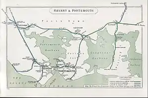
A 1910 Railway Clearing House map of lines around Portsmouth, showing the Southsea Railway
Jessie Road Bridge Halt[1] was an intermediate station situated on the Southsea Railway[2] between Fratton[3] and Albert Road Bridge Halt (sometimes called Highland Road[4]).
Opened in 1904 and closed a decade later it was part of a concerted effort to boost revenue and thus see off competition from the burgeoning tramway network.[5] The station's only platform was on the down line, the up line being out of use.[6] The final nail in the line's coffin was a government directive issued shortly after the declaration of war[4] that railways unable to support themselves would cease operations at the earliest opportunity; and, as the line clearly fell into this category, the last train ran early in August 1914.[3]
Railways in the Portsmouth area |
|---|
| Preceding station | Disused railways | Following station | ||
|---|---|---|---|---|
| Fratton | Southsea Railway | Albert Road Bridge Halt |
See also
References
- ↑ Butt, R.V.J. (1995). The Directory of Railway Stations, Patrick Stephens Ltd, Sparkford, ISBN 1-85260-508-1, p. 129.
- ↑ Mitchell, Vic; Smith, Keith (December 1985). Southern Main Lines: Woking to Portsmouth. Midhurst: Middleton Press. ISBN 0-906520-25-8.
- 1 2 "Hampshire railways remembered" Oppitz,L Newbury, Countryside 1988 ISBN 1-85306-020-8
- 1 2 "The Southsea Railway" Robertson,K: Southampton, Kingfisher, 1985 ISBN 0-946184-16-X
- ↑ "Portsmouth’s tramways" Petch,M: Midhurst, Middleton Press,1996 ISBN 1-873793-72-3
- ↑ Kidner, R. W. (1985). Southern Railway Halts. Survey and Gazetteer. Headington, Oxford: The Oakwood Press. p. 39. ISBN 0-85361-321-4.
External links
This article is issued from Wikipedia. The text is licensed under Creative Commons - Attribution - Sharealike. Additional terms may apply for the media files.