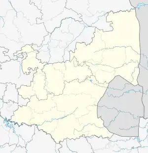
Jeppes Reef | |
|---|---|
 | |
 Jeppes Reef  Jeppes Reef | |
| Coordinates: 25°43′12″S 31°28′37″E / 25.720°S 31.477°E | |
| Country | South Africa |
| Province | Mpumalanga |
| District | Ehlanzeni |
| Municipality | Nkomazi |
| Area | |
| • Total | 7.46 km2 (2.88 sq mi) |
| Population (2011)[1] | |
| • Total | 12,589 |
| • Density | 1,700/km2 (4,400/sq mi) |
| Racial makeup (2011) | |
| • Black African | 99.7% |
| • Coloured | 0.2% |
| • Indian/Asian | 0.1% |
| First languages (2011) | |
| • SiSwati | 96.5% |
| • Other | 3.5% |
| Time zone | UTC+2 (SAST) |
Jeppes Reef, is a small rural village on the R570 road in Ehlanzeni District Municipality in the Mpumalanga province of South Africa, 25 kilometres (16 mi) south-southeast of Kaapmuiden, and just over 2 kilometres (1.2 mi) from the border with Eswatini. It is just south of Schoemansdal.
A border control post operates between 07:00 and 20:00 between the two countries.[2] The Eswatini side of the Matsamo border post is known as Hlohlo.
| South Africa | Eswatini | |
|---|---|---|
| Region | Mpumalanga | |
| Nearest town | Malalane | |
| Road | R570 | MR1 |
| GPS Coordinates | 25°45′03″S 31°28′03″E / 25.7507°S 31.4676°E | 25°45′03″S 31°28′03″E / 25.7507°S 31.4676°E |
| Telephone number | +27 (0) 13 781 0382 | |
| Fax number | +27 (0) 13 781 0383 | |
| Business hours | 07:00 - 20:00 | 07:00 - 20:00 |
References
- 1 2 3 4 "Main Place Jeppes Reef". Census 2011.
- ↑ "South African Ports of entry". Archived from the original on 28 August 2015. Retrieved 22 August 2015. Archived 28 August 2015 at the Wayback Machine
This article is issued from Wikipedia. The text is licensed under Creative Commons - Attribution - Sharealike. Additional terms may apply for the media files.
.svg.png.webp)