| Inini | |
|---|---|
 Confluence of the Inini River with the Lawa River (1903) | |
 | |
| Location | |
| Commune | Saül & Maripasoula, French Guiana |
| Physical characteristics | |
| Source | |
| • location | Confluence of the Emerillon Creek and the Limonade Creek |
| • coordinates | 3°23′49″N 53°14′27″W / 3.3969°N 53.2408°W |
| Mouth | |
• location | Confluence with Lawa |
• coordinates | 03°38′55″N 54°00′15″W / 3.64861°N 54.00417°W |
| Length | 215 km |
| Basin features | |
| Progression | Lawa→ Maroni→ Atlantic Ocean |
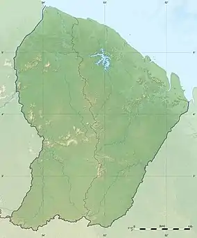
The Inini or Grand Inini is a river in western French Guiana. It is a tributary of the Lawa, the upper course of the Maroni. The river is 215 km (134 mi) long (including its upper course Limonade) and non-navigable.[1] The Inini is the only major river in French Guiana which runs east to west, unlike the other major rivers which run south to north.[2] In the beginning of the 20th century, it was the site of a gold rush, and the gold prospectors have become active in the region again since the 1990s.[3] The Inini territory which has existed between 1930 and 1946 was named after this river.[2]
References
- ↑ Sandre. "Fiche cours d'eau - grand inini (riviere); limonade (crique) (52--0200)".
- 1 2 "Au temps de l'Inini". Un Témoin en Guyane (in French). Retrieved 4 August 2020.
- ↑ Pierre-Michel Forget (2002). "Explorations scientifique et aurifère: le paradoxe de Saint-Eugène, Guyane française" (PDF). Revue d'écologie. Retrieved 4 August 2020.
This article is issued from Wikipedia. The text is licensed under Creative Commons - Attribution - Sharealike. Additional terms may apply for the media files.