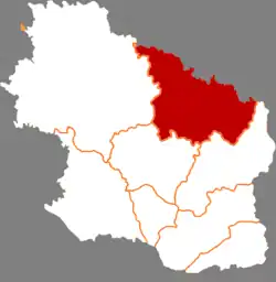
Huachi County
华池县 | |
|---|---|
 Huachi in Qingyang | |
.png.webp) Qingyang in Gansu | |
| Coordinates: 36°27′41″N 107°59′24″E / 36.4614°N 107.9900°E | |
| Country | People's Republic of China |
| Province | Gansu |
| Prefecture-level city | Qingyang |
| Area | |
| • Total | 3,791 km2 (1,464 sq mi) |
| Highest elevation | 1,780 m (5,840 ft) |
| Lowest elevation | 1,100 m (3,600 ft) |
| Population (2018) | |
| • Total | 138,680 |
| • Density | 37/km2 (95/sq mi) |
| Time zone | UTC+8 (China Standard) |
| Postal code | 745600 |
| Website | www |
Huachi County (simplified Chinese: 华池县; traditional Chinese: 華池縣; pinyin: Huáchí Xiàn) is a county in the east of Gansu province, China, bordering Shaanxi province to the north and northeast. It is under the administration of the prefecture-level city of Qingyang. Its postal code is 745600, and its population in 2018 was 138,680 people. Huachi has a low population density and is one of the poorer counties of China, partly because of the dry climate.[1]
Parts of the Qin Great Wall run through Huachi. Huachi was established as a county during the Western Wei dynasty. During the Five Dynasties period it was abolished, becoming part of neighbouring counties. In 1934 it was re-established. During the first encirclement campaign against the Shaanxi–Gansu Soviet it was home to the Nanliang communist base.[1]
Huachi's important agricultural produce includes white melon seeds, daylily, wood ear mushroom and millets.[1]
Administrative divisions
Huachi County is divided to 6 towns and 9 townships.[2]
- Towns
|
|
- Townships
|
|
Climate
| Climate data for Huachi (1991–2016 normals, extremes 1981–2010) | |||||||||||||
|---|---|---|---|---|---|---|---|---|---|---|---|---|---|
| Month | Jan | Feb | Mar | Apr | May | Jun | Jul | Aug | Sep | Oct | Nov | Dec | Year |
| Record high °C (°F) | 14.1 (57.4) |
19.4 (66.9) |
27.0 (80.6) |
34.5 (94.1) |
34.5 (94.1) |
37.7 (99.9) |
38.0 (100.4) |
34.2 (93.6) |
34.8 (94.6) |
27.2 (81.0) |
23.0 (73.4) |
15.6 (60.1) |
38.0 (100.4) |
| Mean daily maximum °C (°F) | 2.2 (36.0) |
6.0 (42.8) |
11.9 (53.4) |
19.0 (66.2) |
23.8 (74.8) |
27.8 (82.0) |
29.0 (84.2) |
27.0 (80.6) |
21.9 (71.4) |
16.2 (61.2) |
9.8 (49.6) |
3.8 (38.8) |
16.5 (61.8) |
| Daily mean °C (°F) | −6.5 (20.3) |
−2.2 (28.0) |
3.9 (39.0) |
10.8 (51.4) |
16.1 (61.0) |
20.4 (68.7) |
22.4 (72.3) |
20.6 (69.1) |
15.3 (59.5) |
8.6 (47.5) |
1.5 (34.7) |
−4.6 (23.7) |
8.9 (47.9) |
| Mean daily minimum °C (°F) | −12.3 (9.9) |
−8 (18) |
−2.2 (28.0) |
3.7 (38.7) |
8.7 (47.7) |
13.4 (56.1) |
16.7 (62.1) |
15.7 (60.3) |
10.7 (51.3) |
3.5 (38.3) |
−3.7 (25.3) |
−10.1 (13.8) |
3.0 (37.5) |
| Record low °C (°F) | −23.1 (−9.6) |
−21.0 (−5.8) |
−15.9 (3.4) |
−7.8 (18.0) |
−2.7 (27.1) |
4.6 (40.3) |
8.8 (47.8) |
5.2 (41.4) |
−0.9 (30.4) |
−9.4 (15.1) |
−16.1 (3.0) |
−26.5 (−15.7) |
−26.5 (−15.7) |
| Average precipitation mm (inches) | 3.1 (0.12) |
5.1 (0.20) |
12.4 (0.49) |
26.4 (1.04) |
38.2 (1.50) |
60.1 (2.37) |
107.5 (4.23) |
100.3 (3.95) |
68.9 (2.71) |
35.3 (1.39) |
13.4 (0.53) |
2.9 (0.11) |
473.6 (18.64) |
| Average precipitation days (≥ 0.1 mm) | 3.0 | 4.0 | 5.4 | 6.4 | 7.8 | 10.2 | 12.2 | 11.4 | 11.0 | 7.8 | 4.5 | 2.4 | 86.1 |
| Average snowy days | 4.3 | 5.2 | 4.0 | 0.7 | 0 | 0 | 0 | 0 | 0 | 0.6 | 2.9 | 3.5 | 21.2 |
| Average relative humidity (%) | 58 | 57 | 54 | 50 | 52 | 58 | 68 | 74 | 76 | 74 | 67 | 61 | 62 |
| Mean monthly sunshine hours | 180.4 | 168.1 | 191.6 | 214.0 | 235.1 | 229.1 | 217.7 | 197.6 | 156.4 | 169.5 | 168.9 | 172.9 | 2,301.3 |
| Percent possible sunshine | 58 | 54 | 51 | 54 | 54 | 52 | 49 | 48 | 43 | 49 | 56 | 58 | 52 |
| Source: China Meteorological Administration[3][4] | |||||||||||||
See also
References
- 1 2 3 "庆阳市华池县情简介" [Brief Introduction of Huachi County, Qingyang City] (in Chinese).
- ↑ "统计用区划代码 www.stats.gov.cn" (in Chinese). XZQH. Retrieved 2020-12-27.
- ↑ 中国气象数据网 – WeatherBk Data (in Simplified Chinese). China Meteorological Administration. Retrieved 27 August 2023.
- ↑ 中国气象数据网 (in Simplified Chinese). China Meteorological Administration. Retrieved 27 August 2023.
External links