Hinoba-an
Asia | |
|---|---|
| Municipality of Hinoba-an | |
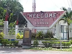
 "Welcome" sign board along the highway | |
 Flag  Seal | |
| Motto: Paspas Hinobaan | |
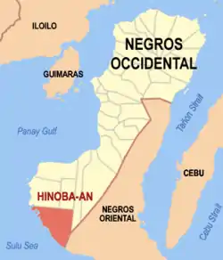
 Map of Negros Occidental with Hinoba-an highlighted | |
OpenStreetMap | |
.svg.png.webp) Hinoba-an Location within the Philippines | |
| Coordinates: 9°36′06″N 122°28′01″E / 9.601789°N 122.466833°E | |
| Country | Philippines |
| Region | Western Visayas |
| Province | Negros Occidental |
| District | 6th district |
| Founded | November 20, 1948 |
| Barangays | 13 (see Barangays) |
| Government | |
| • Type | Sangguniang Bayan |
| • Mayor | Daph Anthony V. Reliquias |
| • Vice Mayor | Jefre L. Encoy |
| • Representative | Mercedes K. Alvarez |
| • Municipal Council | Members |
| • Electorate | 38,279 voters (2022) |
| Area | |
| • Total | 414.50 km2 (160.04 sq mi) |
| Elevation | 78 m (256 ft) |
| Highest elevation | 687 m (2,254 ft) |
| Lowest elevation | 0 m (0 ft) |
| Population (2020 census)[3] | |
| • Total | 60,865 |
| • Density | 150/km2 (380/sq mi) |
| • Households | 14,099 |
| Economy | |
| • Income class | 1st municipal income class |
| • Poverty incidence | 24.63 |
| • Revenue | ₱ 252.4 million (2020) |
| • Assets | ₱ 434.6 million (2020) |
| • Expenditure | ₱ 247.3 million (2020) |
| • Liabilities | ₱ 155.7 million (2020) |
| Service provider | |
| • Electricity | Negros Occidental Electric Cooperative (NOCECO) |
| Time zone | UTC+8 (PST) |
| ZIP code | 6114 |
| PSGC | |
| IDD : area code | +63 (0)34 |
| Native languages | Hiligaynon Tagalog Cebuano |
| Website | www |
Hinoba-an, officially the Municipality of Hinoba-an (formerly Asia[5]), is a 1st class municipality in the province of Negros Occidental, Philippines. According to the 2020 census, it has a population of 60,865 people.[3]
Hinoba-an is the southernmost town of the province. It is bounded on the north by Sipalay City and Candoni; on the south by Basay, Negros Oriental; on the east by the town of Ilog; and on the west by the Sulu Sea. The total land area of Hinoba-an is 421.50 square kilometers. It is 187 kilometres (116 mi) from Bacolod and 154 kilometres (96 mi) from Dumaguete, the capital of Negros Oriental.
The town is home to the Magahat language, the indigenous language of Southern Negros as listed by the Komisyon ng Wikang Filipino. The language is vital to the culture and arts of the people.
History
Formerly a part of Cauayan, Hinoba-an was inhabited by natives called "Magabat". When immigrants from Panay came and settled in the coastal areas, the settlers began to group in the area where the town is now located. Traders visited to barter products like clothing made in Miag-ao, Tigbauan and Guimbal in Iloilo.

Spanish authorities did not occupy Hinoba-an during their time in the province since the area was still a jungle. It was visited only by people from Cauayan and the neighboring towns for hunting purposes, hence no important events were recorded about the coming of the Spaniards in the town until the early 20th century.
In the early 1900s, Don Estanislao Bilbao, a Basque émigré and patriarch of the Bilbao clan---one of the area's prominent families, begun a decades-long process of settling an area south of where Hinoba-an would come to be. In a few years, a significant plot of land had been rehabilitated to which thousands of germinating coconut husks were planted in precise rows. Maturing and bearing crop in under a decade, once coastal wilderness was transformed into copra producing land. Paddy fields were likewise developed further inland close to irrigation sources.
The subsequent grant of landownership, along with the total absence of government due to the area's remoteness, it became the basis for Don Estanislao's provisional administration of the people and the place. He became the area's primary, if not for a time, sole employer. As a matter of moral imperative and practical necessity, he also became the de facto Judge and Sheriff, adjudicating upon and enforcing common law.
Through his marriage to Felicidad Rivas—a patrician heiress to a similarly homesteaded parcel of land nearby, Don Estanislao doubled the size of the holding. Hand-in-hand with Dona Felicidad, they lorded over a highly productive agricultural expanse that, from points north to south, ostensibly stretched for miles on end. The couple's lifelong beneficence and philanthropy endeared them to the local populace making the Bilbao name well-respected and well-loved. Sons Joaquin and Francisco, and daughter-in-law Teresa, have each been elected town's mayor. Today, the Bilbao's have governed the municipality for a collective span of over thirty years.
When the Americans landed in Negros during World War II, Hinoba-an became a historical point of entry by the combined U.S. and Philippine Commonwealth military forces. Col. Salvador Abcede, district commander of the 7th military district, established his island headquarters in this town during the Japanese occupation.
Col. Jesús A. Villamor, aboard submarine USS Gudgeon (SS-211), landed at Ubong Point and occupied Ubong Cave as command post supply food and arms to guerillas.
After Liberation, Hinoba-an was rehabilitated by some of its pioneering residents. More settlements were established, schools were built, trails developed for the people's convenience in going to places and in transporting their local produce to nearby towns and villages. There was also a huge influx of Cebuano-speaking people during this time.
Geography
Barangays


Hinoba-an is politically subdivided into 13 barangays. Each barangay consists of puroks and some have sitios.
Climate
| Climate data for Hinoba-an, Negros Occidental | |||||||||||||
|---|---|---|---|---|---|---|---|---|---|---|---|---|---|
| Month | Jan | Feb | Mar | Apr | May | Jun | Jul | Aug | Sep | Oct | Nov | Dec | Year |
| Mean daily maximum °C (°F) | 29 (84) |
30 (86) |
31 (88) |
32 (90) |
30 (86) |
29 (84) |
28 (82) |
28 (82) |
28 (82) |
28 (82) |
29 (84) |
29 (84) |
29 (85) |
| Mean daily minimum °C (°F) | 21 (70) |
21 (70) |
22 (72) |
23 (73) |
24 (75) |
24 (75) |
24 (75) |
24 (75) |
24 (75) |
24 (75) |
23 (73) |
22 (72) |
23 (73) |
| Average precipitation mm (inches) | 45 (1.8) |
37 (1.5) |
62 (2.4) |
93 (3.7) |
190 (7.5) |
259 (10.2) |
284 (11.2) |
236 (9.3) |
244 (9.6) |
247 (9.7) |
162 (6.4) |
86 (3.4) |
1,945 (76.7) |
| Average rainy days | 10.8 | 8.4 | 12.7 | 16.3 | 26.7 | 28.5 | 29.1 | 28.0 | 27.4 | 28.5 | 23.4 | 15.5 | 255.3 |
| Source: Meteoblue[6] | |||||||||||||
Demographics
| Year | Pop. | ±% p.a. |
|---|---|---|
| 1960 | 8,630 | — |
| 1970 | 17,475 | +7.30% |
| 1975 | 32,357 | +13.15% |
| 1980 | 45,819 | +7.20% |
| 1990 | 40,813 | −1.15% |
| 1995 | 40,819 | +0.00% |
| 2000 | 50,809 | +4.81% |
| 2007 | 53,894 | +0.82% |
| 2010 | 54,624 | +0.49% |
| 2015 | 56,819 | +0.75% |
| 2020 | 60,865 | +1.36% |
| Source: Philippine Statistics Authority[7][8][9][10] | ||
The people of Hinoba-an predominantly speak Cebuano and Hiligaynon, which are used interchangeably every day. Tagalog and English are also understood to some extent.
Economy
Tourism


Salvacion Cave along the vicinity of pebbled beaches of Barangay Talacagay has a natural covered pools ideal for bathing.
Ubong Cave is where the late Col. Jesús A. Villamor, hero of World War II landed bringing firearms for the Philippine guerillas aboard the US Navy Submarine USS Gudgeon (SS-211) in 1942, establishing the first radio contact with General Douglas MacArthur based in Australia at that time.[18]
See also
References
- ↑ Municipality of Hinoba-an | (DILG)
- ↑ "2015 Census of Population, Report No. 3 – Population, Land Area, and Population Density" (PDF). Philippine Statistics Authority. Quezon City, Philippines. August 2016. ISSN 0117-1453. Archived (PDF) from the original on May 25, 2021. Retrieved July 16, 2021.
- 1 2 Census of Population (2020). "Region VI (Western Visayas)". Total Population by Province, City, Municipality and Barangay. Philippine Statistics Authority. Retrieved 8 July 2021.
- ↑ "PSA Releases the 2018 Municipal and City Level Poverty Estimates". Philippine Statistics Authority. 15 December 2021. Retrieved 22 January 2022.
- ↑ Republic Act No. 2154, Chan Robles, retrieved 2012
- ↑ "Hinoba-an: Average Temperatures and Rainfall". Meteoblue. Retrieved 7 May 2020.
- ↑ Census of Population (2015). "Region VI (Western Visayas)". Total Population by Province, City, Municipality and Barangay. Philippine Statistics Authority. Retrieved 20 June 2016.
- ↑ Census of Population and Housing (2010). "Region VI (Western Visayas)" (PDF). Total Population by Province, City, Municipality and Barangay. National Statistics Office. Retrieved 29 June 2016.
- ↑ Censuses of Population (1903–2007). "Region VI (Western Visayas)". Table 1. Population Enumerated in Various Censuses by Province/Highly Urbanized City: 1903 to 2007. National Statistics Office.
{{cite encyclopedia}}: CS1 maint: numeric names: authors list (link) - ↑ "Province of". Municipality Population Data. Local Water Utilities Administration Research Division. Retrieved 17 December 2016.
- ↑ "Poverty incidence (PI):". Philippine Statistics Authority. Retrieved December 28, 2020.
- ↑ "Estimation of Local Poverty in the Philippines" (PDF). Philippine Statistics Authority. 29 November 2005.
- ↑ "2003 City and Municipal Level Poverty Estimates" (PDF). Philippine Statistics Authority. 23 March 2009.
- ↑ "City and Municipal Level Poverty Estimates; 2006 and 2009" (PDF). Philippine Statistics Authority. 3 August 2012.
- ↑ "2012 Municipal and City Level Poverty Estimates" (PDF). Philippine Statistics Authority. 31 May 2016.
- ↑ "Municipal and City Level Small Area Poverty Estimates; 2009, 2012 and 2015". Philippine Statistics Authority. 10 July 2019.
- ↑ "PSA Releases the 2018 Municipal and City Level Poverty Estimates". Philippine Statistics Authority. 15 December 2021. Retrieved 22 January 2022.
- ↑ "Caves of The Philippines: Ubong Caves". www.showcaves.com. Retrieved February 18, 2019.