Himamaylan | |
|---|---|
| City of Himamaylan | |
 Himamaylan City Hall | |
 Flag  Seal | |
| Nickname(s): Maylan Home of Himaya-an Festival and Patik Kawayan | |
| Motto: Onward To More Progress | |
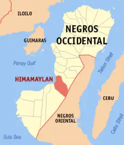
 Map of Negros Occidental with Himamaylan highlighted | |
OpenStreetMap | |
.svg.png.webp) Himamaylan Location within the Philippines | |
| Coordinates: 10°06′N 122°52′E / 10.1°N 122.87°E | |
| Country | Philippines |
| Region | Western Visayas |
| Province | Negros Occidental |
| District | 5th district |
| Founded | 1575 |
| Cityhood | March 5, 2001 |
| Barangays | 19 (see Barangays) |
| Government | |
| • Type | Sangguniang Panlungsod |
| • Mayor | Rogelio Raymund Tongson, Jr. |
| • Vice Mayor | Justin Dominic S. Gatuslao |
| • Representative | Emilio Bernardino L. Yulo III |
| • City Council | Members |
| • Electorate | 73,697 voters (2022) |
| Area | |
| • Total | 367.04 km2 (141.71 sq mi) |
| Elevation | 230 m (750 ft) |
| Highest elevation | 1,459 m (4,787 ft) |
| Lowest elevation | 0 m (0 ft) |
| Population (2020 census)[3] | |
| • Total | 116,240 |
| • Density | 320/km2 (820/sq mi) |
| • Households | 28,225 |
| Economy | |
| • Income class | 3rd city income class |
| • Poverty incidence | 23.96 |
| • Revenue | ₱ 835.4 million (2020) |
| • Assets | ₱ 2,677 million (2020) |
| • Expenditure | ₱ 767.5 million (2020) |
| • Liabilities | ₱ 640.3 million (2020) |
| Service provider | |
| • Electricity | Negros Occidental Electric Cooperative (NOCECO) |
| Time zone | UTC+8 (PST) |
| ZIP code | 6108 |
| PSGC | |
| IDD : area code | +63 (0)34 |
| Native languages | Hiligaynon Tagalog |
| Website | himamaylancity |
Himamaylan (/hiːmɑːˈmaɪlən/), officially the City of Himamaylan (Hiligaynon: Dakbanwa/Syudad sang Himamaylan; Filipino: Lungsod ng Himamaylan), is a 3rd class component city in the province of Negros Occidental, Philippines. According to the 2020 census, it has a population of 116,240 people.[3]
This component city located is 75 kilometres (47 mi) south of Bacolod, the provincial capital. Due to its coastal location, it is a rich source of different types of seafood, mainly fish, oysters, mussels and shrimps. The city celebrates the Himaya-an Festival every April 14–25.
Himamaylan became a city on March 5, 2001, through a proclamation by President Gloria Macapagal Arroyo under Republic Act No. 9028. It is the only city in the 5th District of the province.
Etymology
During the Spanish colonisation, it was once spelt as "Gimamaylan".[5]
History
In 1795, Himamaylan became the capital of Negros.[6] At that time, the city served as a garrison for occupying Spanish forces. Today, the old Spanish-built fort constructed as a lookout point for frequent Moro raids is one of the historical attractions found in the city.[7]
Cityhood
In 2001, the Philippine Congress passed Republic Act No. 9028, providing for the conversion of the municipality into a city after a favourable plebiscite.
Geography
Himamaylan is located at the centre-most cove on the coastline of Negros Island. Himamaylan has a natural harbour characterised by deep waters favourable to access by marine vessels.
Located in the centre of the island, the city is conducive to operations reaching all parts of the country and the rest of Southeast Asia from a strategic point. Most portions of the city are plains and generally have fertile soil, conducive for agriculture. The city's rivers are 12 feet (3.7 m) or deeper, providing drainage for farmland.
Barangays

Himamaylan is politically subdivided into 19 barangays. Each barangay consists of puroks and some have sitios.
- Aguisan
- Buenavista
- Cabadiangan
- Cabanbanan
- Carabalan
- Caradio-an
- Libacao
- Mambagaton
- Nabali-an
- Mahalang
- San Antonio
- Sara-et
- Su-ay
- Talaban
- To-oy
- Barangay I (Poblacion)
- Barangay II (Poblacion)
- Barangay III (Poblacion)
- Barangay IV (Poblacion)
Climate
| Climate data for Himamaylan | |||||||||||||
|---|---|---|---|---|---|---|---|---|---|---|---|---|---|
| Month | Jan | Feb | Mar | Apr | May | Jun | Jul | Aug | Sep | Oct | Nov | Dec | Year |
| Mean daily maximum °C (°F) | 30 (86) |
31 (88) |
32 (90) |
33 (91) |
32 (90) |
30 (86) |
29 (84) |
29 (84) |
29 (84) |
29 (84) |
30 (86) |
30 (86) |
30 (87) |
| Mean daily minimum °C (°F) | 22 (72) |
22 (72) |
22 (72) |
24 (75) |
25 (77) |
25 (77) |
25 (77) |
24 (75) |
24 (75) |
24 (75) |
23 (73) |
23 (73) |
24 (74) |
| Average precipitation mm (inches) | 38 (1.5) |
29 (1.1) |
55 (2.2) |
65 (2.6) |
141 (5.6) |
210 (8.3) |
212 (8.3) |
176 (6.9) |
180 (7.1) |
180 (7.1) |
130 (5.1) |
70 (2.8) |
1,486 (58.6) |
| Average rainy days | 9.0 | 7.2 | 11.1 | 13.5 | 25.6 | 28.4 | 28.9 | 27.3 | 26.9 | 27.7 | 21.8 | 13.8 | 241.2 |
| Source: Meteoblue[8] | |||||||||||||
Demographics
| Year | Pop. | ±% p.a. |
|---|---|---|
| 1903 | 14,932 | — |
| 1918 | 15,559 | +0.27% |
| 1939 | 28,407 | +2.91% |
| 1948 | 33,984 | +2.01% |
| 1960 | 41,985 | +1.78% |
| 1970 | 53,663 | +2.48% |
| 1975 | 65,521 | +4.09% |
| 1980 | 70,467 | +1.47% |
| 1990 | 81,014 | +1.40% |
| 1995 | 83,268 | +0.52% |
| 2000 | 88,684 | +1.36% |
| 2007 | 102,014 | +1.95% |
| 2010 | 103,006 | +0.35% |
| 2015 | 106,880 | +0.71% |
| 2020 | 116,240 | +1.66% |
| Source: Philippine Statistics Authority[9][10][11][12] | ||
The people in the city speak the Hiligaynon language (often called Ilonggo). Filipino and English are generally understood.
Economy

The city's main sources of livelihood include fishery, sugarcane farming and sugar production, rice farming, mango cultivation and ethanol exports.[20]
Sister city
References
- ↑ City of Himamaylan | (DILG)
- ↑ "2015 Census of Population, Report No. 3 – Population, Land Area, and Population Density" (PDF). Philippine Statistics Authority. Quezon City, Philippines. August 2016. ISSN 0117-1453. Archived (PDF) from the original on May 25, 2021. Retrieved July 16, 2021.
- 1 2 Census of Population (2020). "Region VI (Western Visayas)". Total Population by Province, City, Municipality and Barangay. Philippine Statistics Authority. Retrieved July 8, 2021.
- ↑ "PSA Releases the 2018 Municipal and City Level Poverty Estimates". Philippine Statistics Authority. December 15, 2021. Retrieved January 22, 2022.
- ↑ "File:Negros.jpg", Wikipedia, retrieved April 25, 2021
- ↑ "Inside Negros: Himamaylan City". Archived from the original on September 2, 2008. Retrieved September 2, 2008.
- ↑ "Negros Occidental, Himamaylan City". Archived from the original on June 12, 2008. Retrieved September 2, 2008.
- ↑ "Himamaylan: Average Temperatures and Rainfall". Meteoblue. Retrieved May 7, 2020.
- ↑ Census of Population (2015). "Region VI (Western Visayas)". Total Population by Province, City, Municipality and Barangay. Philippine Statistics Authority. Retrieved June 20, 2016.
- ↑ Census of Population and Housing (2010). "Region VI (Western Visayas)" (PDF). Total Population by Province, City, Municipality and Barangay. National Statistics Office. Retrieved June 29, 2016.
- ↑ Censuses of Population (1903–2007). "Region VI (Western Visayas)". Table 1. Population Enumerated in Various Censuses by Province/Highly Urbanized City: 1903 to 2007. National Statistics Office.
{{cite encyclopedia}}: CS1 maint: numeric names: authors list (link) - ↑ "Province of". Municipality Population Data. Local Water Utilities Administration Research Division. Retrieved December 17, 2016.
- ↑ "Poverty incidence (PI):". Philippine Statistics Authority. Retrieved December 28, 2020.
- ↑ "Estimation of Local Poverty in the Philippines" (PDF). Philippine Statistics Authority. November 29, 2005.
- ↑ "2003 City and Municipal Level Poverty Estimates" (PDF). Philippine Statistics Authority. March 23, 2009.
- ↑ "City and Municipal Level Poverty Estimates; 2006 and 2009" (PDF). Philippine Statistics Authority. August 3, 2012.
- ↑ "2012 Municipal and City Level Poverty Estimates" (PDF). Philippine Statistics Authority. May 31, 2016.
- ↑ "Municipal and City Level Small Area Poverty Estimates; 2009, 2012 and 2015". Philippine Statistics Authority. July 10, 2019.
- ↑ "PSA Releases the 2018 Municipal and City Level Poverty Estimates". Philippine Statistics Authority. December 15, 2021. Retrieved January 22, 2022.
- ↑ "About Himamaylan City". Retrieved September 2, 2008.
- ↑ "Himamaylan City eyes sisterhood deal with Taguig City". SunStar Bacolod. November 13, 2012.