| Han River Hán Jiāng | |
|---|---|
 Looking across the Han River from Chaozhou City. | |
| Native name | 韩江 |
| Location | |
| Country | China |
| Province | Guangdong, Fujian, Jiangxi |
| Cities | Meizhou, Chaozhou, Shantou |
| Physical characteristics | |
| Source | Mount Qixingdong (Mei River) |
| • location | Zijin County, Guangdong |
| Mouth | South China Sea |
• location | Shantou, Guangdong |
| Length | 410 km (250 mi)[1] |
| Basin size | 30,112 km2 (11,626 sq mi)[1] |
| Discharge | |
| • average | 870 m3/s (31,000 cu ft/s)[1] |
| • minimum | 33 m3/s (1,200 cu ft/s)[1] |
| • maximum | 13,300 m3/s (470,000 cu ft/s)[1] |
| Basin features | |
| Tributaries | |
| • left | Wuhua River, Ning River, Shiku River |
| • right | Ting River, Meitan River |
The Han River (simplified Chinese: 韩江; traditional Chinese: 韓江; pinyin: Hán Jiāng) is a river in southeast China. It is located mainly in eastern Guangdong and has a total length of 410 kilometres (250 mi). The river is combined with two main tributary rivers, Mei River and Ting River, at Sanheba (三河坝), Dabu County.[2] Han River flows south through the Han River Delta entering the South China Sea at Chenghai District and Longhu District of Shantou.[1] The Teochew people refer to the river as "the Mother River".[3]
The river is named after Han Yu, a writer, poet and government official of the Tang dynasty, in honor of his contribution to Chaoshan.[4] It was originally named as E Xi (simplified Chinese: 恶溪; traditional Chinese: 惡溪; lit. 'ferocious river') before Han Yu's exile to Chaozhou. The river became pacific under Han's river regulation and named after him after his departure.[5]
Gallery
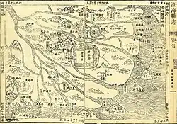
 Map of Chenghai County in Ming dynasty, also indicates the delta and mouth of Han River.
 The Guangji Bridge crosses the Han River in Chaozhou.
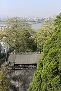
 View of Han River, Guangji Bridge and Chaozhou City at Han Yu's temple.
References
- 1 2 3 4 5 6 "韩江流域". Archived from the original on 2018-04-11. Retrieved 2018-04-11.
- ↑ "三河古镇:汇三江流碧 扼埔邑咽喉". Archived from the original on 2018-11-18. Retrieved 2018-04-09.
- ↑ 潮汕母亲河韩江入选年度全国最美家乡河
- ↑ Teochews Can Take Pride in Successes
- ↑ 专家视点:韩江是一条什么江?
24°03′02″N 116°31′58″E / 24.05054°N 116.532669°E