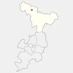
Gunwi
군위군 | |
|---|---|
| Korean transcription(s) | |
| • Hangul | 군위군 |
| • Hanja | 軍威郡 |
| • Revised Romanization | Gunwi-gun |
| • McCune-Reischauer | Kunwi-gun |
 Flag  Emblem of Gunwi | |
 Location in Deagu | |
| Country | |
| Region | Yeongnam |
| Administrative divisions | 1 eup, 7 myeon |
| Area | |
| • Total | 614.15 km2 (237.12 sq mi) |
| Population | |
| • Total | 34,293 |
| • Density | 55/km2 (140/sq mi) |
| • Dialect | Gyeongsang |
Gunwi County (Gunwi-gun) is a county in Daegu Metropolitan City, South Korea.
Gunwi County was part of the North Gyeongsang Province until June 30th, 2023, and incorporated into Daegu Metropolitan City since July 1, 2023.
Administrative divisions

Map of Gunwi County in Korean
Gunwi County is divided into 1 eup and 7 myeon.
| Map | Hangeul | Hanja |
|---|---|---|
| Gunwi-eup | 군위읍 | 軍威邑 |
| Sobo-myeon | 소보면 | 召保面 |
| Hyoryeong-myeon | 효령면 | 孝令面 |
| Bugye-myeon | 부계면 | 缶溪面 |
| Ubo-myeon | 우보면 | 友保面 |
| Uiheung-myeon | 의흥면 | 義興面 |
| Sanseong-myeon | 산성면 | 山城面 |
| Samgugyusa-myeon | 삼국유사면 | 三國遺事面 |
Climate
Gunwi has a humid continental climate (Köppen: Dwa), but can be considered a borderline humid subtropical climate (Köppen: Cwa) using the −3 °C (27 °F) isotherm.
| Climate data for Gunwi (1993–2020 normals) | |||||||||||||
|---|---|---|---|---|---|---|---|---|---|---|---|---|---|
| Month | Jan | Feb | Mar | Apr | May | Jun | Jul | Aug | Sep | Oct | Nov | Dec | Year |
| Mean daily maximum °C (°F) | 4.2 (39.6) |
7.4 (45.3) |
13.5 (56.3) |
20.1 (68.2) |
25.5 (77.9) |
28.7 (83.7) |
30.5 (86.9) |
31.2 (88.2) |
26.6 (79.9) |
21.0 (69.8) |
13.5 (56.3) |
6.1 (43.0) |
19.0 (66.2) |
| Daily mean °C (°F) | −2.7 (27.1) |
0.1 (32.2) |
5.6 (42.1) |
12.0 (53.6) |
17.5 (63.5) |
21.8 (71.2) |
24.9 (76.8) |
25.2 (77.4) |
19.8 (67.6) |
12.8 (55.0) |
5.8 (42.4) |
−1.0 (30.2) |
11.8 (53.2) |
| Mean daily minimum °C (°F) | −8.6 (16.5) |
−6.4 (20.5) |
−1.5 (29.3) |
4.3 (39.7) |
10.1 (50.2) |
15.9 (60.6) |
20.6 (69.1) |
20.9 (69.6) |
15.1 (59.2) |
7.0 (44.6) |
−0.3 (31.5) |
−6.7 (19.9) |
5.9 (42.6) |
| Average precipitation mm (inches) | 14.4 (0.57) |
20.2 (0.80) |
40.5 (1.59) |
70.6 (2.78) |
74.1 (2.92) |
114.2 (4.50) |
197.5 (7.78) |
228.1 (8.98) |
133.0 (5.24) |
51.8 (2.04) |
30.2 (1.19) |
12.9 (0.51) |
987.5 (38.88) |
| Average precipitation days (≥ 0.1 mm) | 2.9 | 3.5 | 5.8 | 6.8 | 6.9 | 8.3 | 12.3 | 12.1 | 8.0 | 4.9 | 4.8 | 2.9 | 79.2 |
| Source: Korea Meteorological Administration[1] | |||||||||||||
References
- ↑ "Climatological Normals of Korea (1991 ~ 2020)" (PDF) (in Korean). Korea Meteorological Administration. Archived from the original (PDF) on 29 January 2022. Retrieved 7 June 2023.
External links
36°14′05″N 128°34′22″E / 36.2347222322°N 128.572777788°E
This article is issued from Wikipedia. The text is licensed under Creative Commons - Attribution - Sharealike. Additional terms may apply for the media files.