Gonder
ጎንደር Gonder | |
|---|---|
City and woreda | |
| Gondar | |
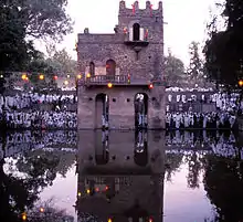
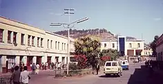
From top, left to right: View of Gondar; Gondar Piasa; Backroad in Gondar City; Gondar from Goha Hotel; Enqualal Gemb; and Debre Berhan Selassie Church | |
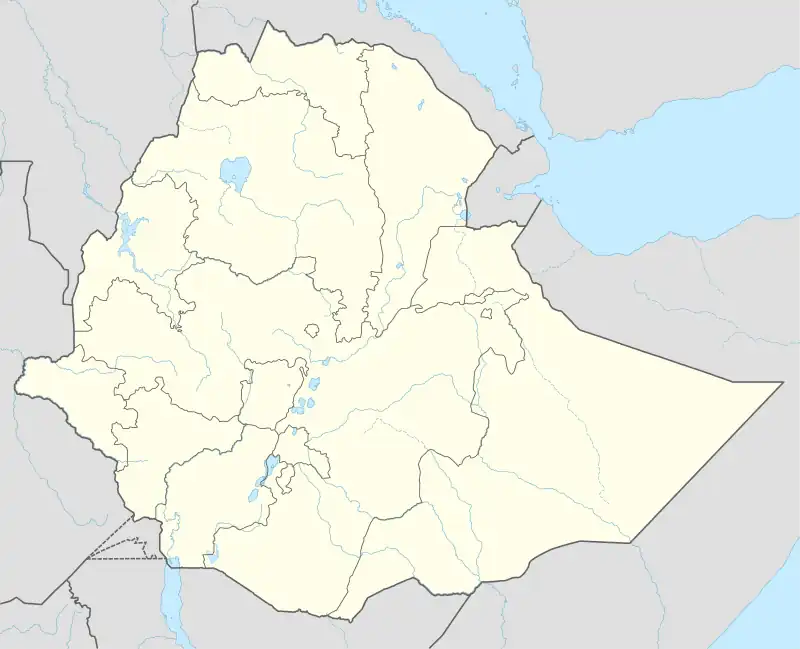 Gonder Location within Ethiopia .svg.png.webp) Gonder Location within the Horn of Africa  Gonder Location within Africa | |
| Coordinates: 12°36′27″N 37°27′33″E / 12.60750°N 37.45917°E | |
| Country | |
| Region | |
| Zone | North Gondar |
| Founded | - |
| Founded by | - |
| Area | |
| • Total | 192.27 km2 (74.24 sq mi) |
| Elevation | 2,133 m (6,998 ft) |
| Population (2007)[1] | |
| • Total | 207,044 |
| • Estimate (2023)[2] | 487,224 |
| • Density | 1,100/km2 (2,800/sq mi) |
| Time zone | UTC+3 (EAT) |
Gondar, also spelled Gonder (Amharic: ጎንደር, Gonder[lower-alpha 1] or Gondär;[lower-alpha 2] formerly ጐንደር, Gʷandar or Gʷender), is a city and woreda in Ethiopia. Located in the North Gondar Zone of the Amhara Region, Gondar is north of Lake Tana on the Lesser Angereb River and southwest of the Simien Mountains. As of 2023, Gondar has an estimated population of 487,224.
Gondar previously served as the capital of both the Ethiopian Empire and the subsequent Begemder Province. The city holds the remains of several royal castles, including those in the Fasil Ghebbi UNESCO World Heritage Site for which Gondar has been called the "Camelot of Africa".[3]
History
17th century
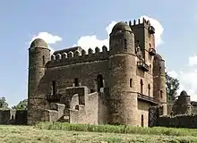
Gondar was originally a small market town inhabited by Muslim traders and Beta Israel craftsmen. In 1635 Emperor Fasilides selected Gondar as his camp, certainly for the purpose of directly supervising the collection of customs on the Red Sea - Tana - Ennarya trade routes. This was the same reason that induced his immediate predecessors, beginning with Emperor Sarsa Dengel in the 1570s, located their capitals on Lake Tana's northeastern flank, along with a concern for safety in view of Oromo conquests in the central highlands. Situated about 35 km due north of the lake in the midst of Kémant country, Gondar was on, or close to, the point at which the main caravan track from Metemma to Tana joined the route from Ennarya to the Red Sea. Other advantages were a semi-circle of mountains that afforded protection, nearby fertile agricultural lands and a permanent water supply. Popular legends, how-ever, maintain that Fasilides was led to the site by prophecy and miraculous events.
Within the capital, Fasilides ordered the construction of the imposing edifice known as the Fasil Ghebbi or Fasilides Castle. Further, he established five other churches, including Mädòane Aläm and Fit Abbo (the latter close to the church of Arbaétu Ensésa, one of the four local churches that predate Gondar's founding). The pleasure-pool with stone pavilion beside the Qaha river known as the "Bath of Fasilides" and several bridges are also commonly attributed to him. In 1648, a Yemeni traveler who visited Gondar, Hassan ibn Ahmad al-Haymi, found Christians and Muslims residing in separate communities and living in straw huts, whereas the castle was "... a lofty structure, among the most wonderful of splendid constructions and ... built of stone and lime ... This castle ... is on the outside of the city and at the highest spot in it; it comprises numerous buildings and large squares".[4]
In 1668, as a result of a church council, the Emperor Yohannes I ruled that the inhabitants of Gondar were to be segregated by religion. This caused the Muslims and Jews to move into their own quarters within two years. The decree, reissued in 1676, meant that almost all Muslims in Gondar subsequently resided in the lower part of the town beside the Qaha, a quarter known as Eslam Bet or Eslamge. The Beta Israel were assigned four quarters, two of them, Abarra and Kayla Meda, beside the Qaha. Aside from the royal enclosure, known as the Makkabäbiya or Fail Gémb, other significant quarters were the Addebabay, a public square on the south of the royal compound, a place of assemblies and the Monday market; Abun Bet, north-west of the castles, residence of the abun, or Metropolitan, and a place of asylum; Eccäge Bet, west of the castles, residence of the -éccäge and also a refuge for offenders; Qañn Bet, east-south-east of the castles and home to many nobles; and Déngay, further south-west and inhabited by Christian merchants. To the far south-south-east lay the main (Saturday) market and beyond it, Eslamge at the foot of the Gondar's plateau. By the reign of Iyasu the Great, the city's population is estimated to have exceeded 60,000. Many of the buildings from this period survive, despite the turmoil of the eighteenth century. [5]
18th century
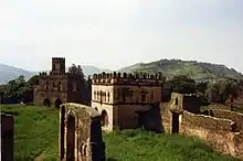
As Gondar expanded, successive emperors built new palaces, churches, and monuments. Empress Mentewab built her own palace near the vicinity of Fasilides' royal compound, and also constructed a church near her residence, adorned by beautiful paintings and illuminated manuscripts. Fires, such as the one in 1732 during the defeat of a rebel force loyal to Iyasu II, provided excuses for emperors to engage in construction. The city's growth, fueled by trade conducted in weekly markets south of the castle complex, also influenced demographics. Ecclesiastical suburbs emerged, including the Muslim Islambet or Islamge, the Jewish community of Falasha Bet involved in blacksmithing and pottery, and Echege Bet and Abuna Bet, both centers for the Ethiopian Church. Poetry and music became preeminent, as the city would become renowned for its secular songs, several Gondarine poets achieved nation wide reputation.
The Oromo influence in Gondar rapidly began to increase in the 18th century. The last Gondarine Emperor to exercise full control was Iyasu II, during his reign multiple revolts broke out and it became apparent that the country was on the eve of political change. He was succeeded by Iyoas I, who effectively became an Oromo puppet. The city was now guarded by 3,000 Oromo troops and had essentially been taken over by the Oromos. In the face of overwhelming opposition towards the Oromo newcomers, Iyoas was forced to appeal to the powerful warlord Mikael Sehul. Ras Mikael thus became master of Gondar, and later had Iyoas deposed and murdered. The Empire thus entered a period of supreme difficulty when its authority declined during the Zemene Mesafint.[6]
19th century
Gondar's fortunes declined further as the locus of the kingdom shifted south-east to Shewa. After the mid-1850s, no more emperors reigned in Gondar, Emperor Tewodros II refused to live there and he suspected its population of disloyalty. In early 1864, he sought to compel Muslims to convert to Christianity, a decree that fell heavily upon Gondar's numerous Muslims, most of whom complied, if only nominally. Later that year, Tewodros sent his soldiers to sack the city. Confronted with further opposition, Tewodros and his army plundered and burned Gondar in December 1866. Most churches were looted and destroyed and their treasures - gold and silver crosses, nearly 1,000 manuscripts - were carted off to Debre Tabor, Tewodros's capital, that he intended to become the "new Gondar"[7][8]
In January 1888 and again in June 1889, the Sudanese Dervishes (Mahdists) burned what was left of Gondar, even the Muslim inhabitants weren’t spared. By the early 20th century, the population had dwindled to a few thousand. Muslims still controlled the caravan trade, which was confined mostly to the regional level, and some had begun to settle in the upper town close to the castles. A German traveller Felix Rosen labelled Gondar "a dead city that belongs wholly to the past".[9]
20th century
After the military occupation of Ethiopia by the Kingdom of Italy in 1936, Gondar was further developed under Italian occupation.[10]: 28–37 Local inhabitants were segregated into districts west and south of the castle enclosure, Italians settling in northern and north-eastern areas. New commercial and government buildings were erected north-east of the castles and a retail district, known hence-forth as the "piazza", was laid out adjacent to the castle compound, all in 1930s "modernist" architecture. A central artery linked the Italian quarters, piazza, Ethiopian merchant quarter, and Saturday market. Another new road ran west of the Fasil "bath" and on to Azezo, where a landing-strip provided an air service with Asmara. Other new roads connected the city with Gojjam and with Eritrea, the latter a paved, all-season roadway. Colonial authorities, seeking to curry favour with local Muslims, built a mosque (for the first time with minaret) beside the Saturday market, authorized the appointment of a gadi for matters involving the Sara and permitted Muslims to settle outside Addis Alem.
During the Second World War, Mussolini's Italian forces made their last stand in Gondar in November 1941, after Addis Ababa fell to British forces six months before. The area of Gondar was one of the main centers of activity of Italian guerrilla against the British forces until summer 1943.[10]: 55–60
During the Ethiopian Civil War, the forces of the Ethiopian Democratic Union (EDU) gained control of large parts of Begemder, and around 1977 the EDU operated within a few kilometers of Gondar, and appeared to be at the point of capturing the city.[11] As part of Operation Tewodros near the end of the Civil War, Gondar was captured by the Ethiopian People's Revolutionary Democratic Front in March 1991.[12]
Cityscape
Gondar traditionally was divided into several neighborhoods or quarters: Addis Alem, where the Muslim inhabitants dwelt; Kayla Mayda, where the adherents of Beta Israel lived; Abun Bet, centered on the residence of the Abuna, or nominal head of the Ethiopian Church; and Qagn Bet, home to the nobility.[10]: 16ff Gondar is also a noted center of ecclesiastical learning of the Ethiopian Orthodox Tewahedo Church, and known for having 44 churches – for many years more than any other settlement in Ethiopia. Gondar and its surrounding countryside constitute the homeland of most Ethiopian Jews.
The modern city of Gondar is popular as a tourist destination for its many picturesque ruins in Fasil Ghebbi (the Royal Enclosure), from which the emperors once reigned. The most famous buildings in the city lie in the Royal Enclosure, which include Fasilides' castle, Iyasu's palace, Dawit's Hall, a banqueting hall, stables, Empress Mentewab's castle, a chancellery, library and three churches. Near the city lie Fasilides' Bath, home to an annual ceremony where it is blessed and then opened for bathing; the Qusquam complex, built by Empress Mentewab; the eighteenth century Ras Mikael Sehul's Palace and the Debre Berhan Selassie Church.
Downtown Gondar shows the influence of the Italian occupation of the late 1930s. The main piazza features shops, a cinema, and other public buildings in a simplified Italian Moderne style still distinctively of the period despite later changes and, frequently, neglect. Villas and flats in the nearby quarter that once housed occupation officials and colonists are also of interest.
Education
The town is home to the University of Gondar, which includes Ethiopia's main faculty of medicine. Teda Health Science College is also located at this town.
Demographics
| Year | Pop. | ±% |
|---|---|---|
| 1984 | 80,886 | — |
| 1994 | 112,249 | +38.8% |
| 2007 | 207,044 | +84.5% |
| 2023 | 487,224 | +135.3% |
| source:[13] | ||
Based on the 2007 national census conducted by the Central Statistical Agency of Ethiopia (CSA), the woreda had a total population of 207,044, an increase of 84.45% from the 1994 census, of whom 98,120 were male and 108,924 female. A total of 53,725 households were counted in this woreda, resulting in an average of 3.85 persons to a household, and 50,818 housing units. The majority of the inhabitants practiced Ethiopian Orthodox Christianity, with 84.15% reporting that as their religion, while 11.77% of the population said they were Muslim.[1]
The 1994 national census reported a total population for this woreda of 112,249 in 22,932 households, of whom 51,366 were male and 60,883 female. The three largest ethnic groups reported in Gondar were the Amhara (88.91%), Tigrayans (6.74%), and Qemant (2.37%); all other ethnic groups made up 1.98% of the population. Amharic was spoken as a first language by 94.57% of the population and Tigrinya was spoken as a first language by 4.67% of the population; the remaining 0.76% spoke all other primary languages reported. 83.31% practiced Ethiopian Orthodox Christianity, and 15.83% of the population said they were Muslim.[14]
Transport
Air transport is served by Gondar Airport (ICAO code HAGN, IATA GDQ), also known as Atse Tewodros Airport, after the Emperor of Ethiopia (Atse) Tewodros. It is 18 km (11 miles) south of the city.[15] Travel within Gondar is mostly done by mini-buses and 3-wheeler motorcycles (accommodating 3–4 passengers).
Intercity bus service is provided by the Sky Bus Transport System, as well as independently owned buses that depart from the town bus station.
Climate
The climate of Gondar is mild, temperate to warm, with an average temperature of 20 °C year round.[16] Köppen-Geiger climate classification system classifies its climate as subtropical highland (Cwb).[17]
| Climate data for Gondar (1981–2010, extremes 1924–present) | |||||||||||||
|---|---|---|---|---|---|---|---|---|---|---|---|---|---|
| Month | Jan | Feb | Mar | Apr | May | Jun | Jul | Aug | Sep | Oct | Nov | Dec | Year |
| Record high °C (°F) | 31.0 (87.8) |
33.4 (92.1) |
33.5 (92.3) |
34.1 (93.4) |
33.4 (92.1) |
34.8 (94.6) |
26.6 (79.9) |
31.0 (87.8) |
29.9 (85.8) |
29.6 (85.3) |
29.7 (85.5) |
30.2 (86.4) |
34.8 (94.6) |
| Mean daily maximum °C (°F) | 28 (82) |
29 (84) |
29 (84) |
30 (86) |
29 (84) |
25 (77) |
23 (73) |
23 (73) |
25 (77) |
26 (79) |
27 (81) |
27 (81) |
27 (80) |
| Daily mean °C (°F) | 19.8 (67.6) |
21.5 (70.7) |
22.7 (72.9) |
22.7 (72.9) |
21.7 (71.1) |
19.7 (67.5) |
17.8 (64.0) |
17.9 (64.2) |
18.7 (65.7) |
19.2 (66.6) |
19.3 (66.7) |
19.4 (66.9) |
20.0 (68.0) |
| Mean daily minimum °C (°F) | 12 (54) |
13 (55) |
14 (57) |
15 (59) |
15 (59) |
14 (57) |
13 (55) |
13 (55) |
13 (55) |
13 (55) |
12 (54) |
12 (54) |
13 (56) |
| Record low °C (°F) | 3.0 (37.4) |
5.2 (41.4) |
6.2 (43.2) |
9.2 (48.6) |
5.5 (41.9) |
6.0 (42.8) |
8.4 (47.1) |
8.0 (46.4) |
7.0 (44.6) |
6.0 (42.8) |
4.5 (40.1) |
1.6 (34.9) |
1.6 (34.9) |
| Average rainfall mm (inches) | 2 (0.1) |
2 (0.1) |
13 (0.5) |
32 (1.3) |
72 (2.8) |
160 (6.3) |
293 (11.5) |
275 (10.8) |
112 (4.4) |
60 (2.4) |
12 (0.5) |
4 (0.2) |
1,037 (40.9) |
| Average rainy days (≥ 0.1 mm) | 0 | 0 | 2 | 5 | 12 | 13 | 20 | 21 | 19 | 15 | 3 | 0 | 110 |
| Average relative humidity (%) | 44 | 40 | 39 | 39 | 52 | 69 | 79 | 79 | 72 | 65 | 56 | 48 | 57 |
| Mean monthly sunshine hours | 291.4 | 243.0 | 229.4 | 249.0 | 238.7 | 183.0 | 114.7 | 139.5 | 204.0 | 229.4 | 240.0 | 279.0 | 2,641.1 |
| Mean daily sunshine hours | 9.4 | 8.6 | 7.4 | 8.3 | 7.7 | 6.1 | 3.7 | 4.5 | 6.8 | 7.4 | 8.0 | 9.0 | 7.2 |
| Source 1: World Meteorological Organisation (average high and low, and rainfall)[18] | |||||||||||||
| Source 2: Deutscher Wetterdienst (mean temperatures 1954–1990, humidity 1957–1982, and sun 1937–1990)[19] Meteo Climat (record highs and lows)[20] | |||||||||||||
Sister cities
As designated by Sister Cities International, Gondar is a sister city with:
 Corvallis, Oregon, United States
- Florence, Italy
 Rishon LeZion, Israel
Notable people
- Abby Lakew
- Aster Aweke: singer
- Eténèsh Wassié: singer and Azmari
- Haile Gerima
- Yityish Titi Aynaw: Miss Israel 2013
- Liliana Mele: actress
- Tamagn Beyene: human rights activist
See also
- List of Gondarine churches
- Gultosh – a deserted village near Gondar
- Azezo – a nearby village south of Gondar
Notes
- ↑ Based on the BGN/PCGN romanization of Amharic.
- ↑ Based on the EAE romanization of Amharic.
References
- 1 2 Census 2007 Tables: Amhara Region, Tables 2.1, 2.4, 2.5, 3.1, 3.2 and 3.4.
- ↑ "Population Projection Towns as of July 2023" (PDF). Ethiopian Statistics Agency. 2023. Retrieved 26 August 2023.
- ↑ http://bjtoursandtrekking.com/tours/index.htm Gondar World Heritage Site
- ↑ Richard K.P. Pankhurst, History of Ethiopian Towns: From the Middle Ages to the Early Nineteenth Century (Wiesbaden: Franz Steiner Verlag, 1982), vol. 1 p. 117.
- ↑ Richard K.P. Pankhurst, History of Ethiopian Towns: From the Middle Ages to the Early Nineteenth Century (Wiesbaden: Franz Steiner Verlag, 1982), vol. 1 p. 117.
- ↑ Richard K.P. Pankhurst, History of Ethiopian Towns: From the Middle Ages to the Early Nineteenth Century (Wiesbaden: Franz Steiner Verlag, 1982), vol. 1 p. 117.
- ↑ Sven Rubenson, King of Kings: Tewodros of Ethiopia (Addis Ababa: Haile Selassie I University, 1966), pp.71
- ↑ R. Pankhurst, in UNESCO General History of Africa, Vol VI: Africa in the Nineteenth Century p.397
- ↑ "Local History in Ethiopia" Archived 2008-05-29 at the Wayback Machine (pdf) The Nordic Africa Institute website (accessed 9 May 2008)
- 1 2 3 Getamun, Solomon (2005). History of the City of Gondar. Africa World Press. ISBN 1569021953.
- ↑ Marina and David Ottaway, Ethiopia: Empire in Revolution (New York: Africana, 1978), p. 171
- ↑ Henze, Paul B (2000). Layers of Time: A History of Ethiopia. p. 322. ISBN 1137117869.
- ↑ "Population Size by Sex, Region, Zone and Wereda" (PDF). Stats Ethiopia. Retrieved 26 August 2023.
- 1 2 1994 Population and Housing Census of Ethiopia: Results for Amhara Region, Vol. 1, part 1, Tables 2.1, 2.7, 2.10, 2.13, 2.17, Annex II.2 (Retrieved 29 May 2022)
- ↑ "Gondar Atse Tewodros Airport". Ethiopian Airports Enterprise. Archived from the original on 3 December 2013. Retrieved 27 June 2014.
- ↑ "Archived copy" (PDF). Archived (PDF) from the original on 31 March 2019. Retrieved 6 October 2019.
{{cite web}}: CS1 maint: archived copy as title (link) - ↑ "Gonder – Climate graph, Temperature graph, Climate table". Climate-Data.org. Archived from the original on 17 November 2015. Retrieved 17 November 2015.
- ↑ "World Weather Information Service – Gondar". World Meteorological Organisation. Archived from the original on 23 October 2013. Retrieved 31 March 2019.
- ↑ "Klimatafel von Gondar (Gonder), Provinz Gondar / Äthiopien" (PDF). Baseline climate means (1961–1990) from stations all over the world (in German). Deutscher Wetterdienst. Archived (PDF) from the original on 31 March 2019. Retrieved 31 March 2019.
- ↑ "Station Gondar" (in French). Météo Climat. Archived from the original on 24 February 2021. Retrieved 31 March 2019.
External links
- . Encyclopædia Britannica. Vol. 11 (11th ed.). 1911.
- Ethiopian Treasures – Fasilados Castle, Felasha Village – Gonder Archived 3 March 2016 at the Wayback Machine
- Pictures from Gonder
.jpg.webp)
.jpg.webp)


.jpg.webp)