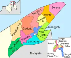
Mukim Gadong 'B' | |
|---|---|
 The Rizqun International Hotel | |
 Gadong is in peach. | |
| Coordinates: 4°31′34″N 114°37′09″E / 4.5262°N 114.6193°E | |
| Country | Brunei |
| District | Brunei-Muara |
| Established | 21 November 2005[1] |
| Area | |
| • Total | 2,456.4997 ha (6,070.1430 acres) |
| Population (2016)[2] | |
| • Total | 33,637 |
| • Density | 1,400/km2 (3,500/sq mi) |
| Time zone | UTC+8 (BNT) |
| Postcode | BExx18, BExx19 |
Mukim Gadong 'B' is a mukim in Brunei-Muara District. Brunei. The population was 33,637 in 2016.[2]
Background
The mukim was established on 21 November 2005 with split of the former Mukim Gadong into this mukim and Mukim Gadong 'A'.[1]
Geography
The mukim is located in the central western part of the district, bordering Mukim Gadong 'A' to the north, Mukim Berakas 'A' to the north-east, Mukim Kianggeh to the east and south and Mukim Kilanas to the south and west.
Demographics
As of 2016 census,[2] the population of Mukim Gadong 'B' comprised 17,044 males and 16,593 females. The mukim had 6,710 households occupying 6,639 dwellings. The entire population lived in urban areas.
Settlements
Mukim Gadong 'B' encompsses the following settlements:[2]
- Kampong Beribi
- Kampong Kiarong
- Kampong Kiulap
- Kampong Mata-Mata
- Kampong Menglait
- Kampong Pengkalan Gadong
- Kampong Perpindahan Mata-Mata
- STKRJ Katok 'B'
Gadong commercial area is located within Bandar Seri Begawan.
References
- 1 2 Norliah Md. Zain (18 July 2015). "Mendekati Mukim Gadong B". Pelita Brunei (in Malay). Retrieved 3 July 2021.
- 1 2 3 4 "Population and Housing Census Update Final Report 2016" (PDF). www.deps.gov.bn. Statistics Department. December 2018. Retrieved 27 June 2021.