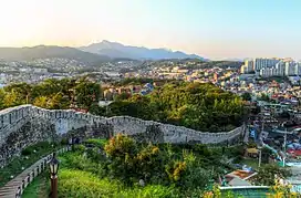
| Fortress Wall of Seoul | |
|---|---|
서울 한양도성 | |
 View of the wall from Naksan Park (2016) | |
 Map of Seoul with the wall in brown | |
| General information | |
| Type | Fortress |
| Address | Jongno-gu |
| Town or city | Seoul |
| Country | |
| Coordinates | 37°35′43″N 126°58′50″E / 37.59528°N 126.98056°E |
| Construction started | 1396 |
| Owner | Government of South Korea |
| Management | Seoul Metropolitan Government |
| Dimensions | |
| Circumference | 18.2 km |
| Technical details | |
| Size | 467,922.6 m2 |
| Other information | |
| Public transit access | |
| Korean name | |
| Hangul | 서울 한양도성 |
| Hanja | |
| Revised Romanization | Hanyangdoseong |
| McCune–Reischauer | Hanyangdosong |
The Fortress Wall of Seoul (Korean: 서울 한양도성) is a series of walls made of stone, wood and other materials, built to protect the city of Seoul against invaders. The wall was first built in 1396 to defend and show the boundaries of the city during the Joseon period. The wall stretches 18.6 km along the ridge of Seoul's four inner mountains, Bugaksan, Inwangsan, Naksan and Namsan. At present, a 12-km section of the wall is designated as Historic Site No. 10 (1963) and is protected accordingly, along with the gates, water gates, and signal fire mounds. The northern, eastern, and southern sections of Namsan (Namsan section) walls have undergone extensive restoration work, having sustained damage or been entirely destroyed during the Japanese colonial period.
Construction
In 1395, five years after King Taejo founded the Joseon Dynasty, he established a government office Doseongchukjoedogam (도성축조도감; 都城築造都監) in order to build a defensive castle. He ordered Jeong Do-jeon to search for a suitable location and plan the construction.
On 1 January 1396 (by the lunar calendar), Taejo of Joseon held the groundbreaking ceremony. 197,400 young men were placed under civil conscription over two years and completed building the castle 98 days after the war along the mountains Bugaksan, Naksan, Namsan, and Inwangsan. The wall contained eight gates, all of which were originally constructed between 1396 and 1398.
Characteristics
.jpg.webp)
The original walls, built in the late 14th century were constructed of medium-sized round stones held together by mud. During King Sejong the Great's reign in the mid-15th century, a large-scale refurbishment work was carried out on the wall, including the replacement of earthen wall sections with rectangular stone sections.[1] A major restoration in 1704 by King Sukjong rebuilt sections of the wall using large, uniform stone slabs which mark the final and last unique characteristic of Hanyangdoseong.[2]
The eastern section of Seoul was on lower ground than the other sections and was more susceptible to external attack. Thus, a lookout was added to the outside of the gate to reinforce its defense. A part of the walls in the section between Heunginjimun and Gwanghuimun was extended outside in a rectangular shape for such a purpose. Signal fire mounds, another component of the defense system, were first established in 1394 and remained in operation until 1894. Signals sent across the country from one mound to another, using smoke by day and fire at night, were received by the beacon at the top of Namsan and conveyed to the Royal Palace.
Gates

Four main gates and four auxiliary gates were built around Seoul in the late 14th century. The four main gates were Heunginjimun (East Gate), Donuimun (West Gate), Sungnyemun (South Gate), and Sukjeongmun (North Gate). The four auxiliary gates were placed in areas between the four main gates, with Souimun (in the southwest), Changuimun (in the northwest), Hyehwamun (in the northeast), and Gwanghuimun (in the southeast).
At present, the following gates are either preserved in their original form or have undergone restoration work: Sungnyemun (South Gate) and Heunginjimun (East Gate) are designated as National Treasure No. 1 and Treasure No. 1, respectively.[1]
Present condition
.jpg.webp)
Hanyangdoseong, completed in 30 years, was torn down in many parts due to city planning initiatives and the introduction of trams lines. However, significant sections of the wall remain. The best-preserved and well-known course is the Wall of Mt. Bukaksan, the 2.3-km trail which cuts through Sukjeongmun to Changuimun. Previously off-limits to the public after having been designated as a Military Reserve area due to its close proximity to Cheongwadae, it opened to the public in 2006. With very few alterations or artificial structures surrounding the area over the years, the natural environment remains relatively intact.[3]
Trail tour
The city of Seoul operates the Hanyangdoseong stamp trail tour, which runs along the wall, divided into six trails:[4]
- Baegak Mountain Trail
- Naksan Mountain Trail
- Heunginjimun Gate Trail
- Namsan(Mongmyeoksan) Mountain Trail
- Sungnyemun Gate Trail
- Inwangsan Mountain Trail
Gallery
_2011%EB%85%84_11%EC%9B%94_%EB%8C%80%ED%95%9C%EB%AF%BC%EA%B5%AD_%EC%84%9C%EC%9A%B8%ED%8A%B9%EB%B3%84%EC%8B%9C_%EB%AA%85%EC%86%8C_(Seoul_best_attractions)_%EC%82%AC%EB%B3%B8_-%EB%82%99%EC%82%B0%EC%95%BC%EA%B2%BD1-1.jpg.webp) A night view from Naksan Mountain
A night view from Naksan Mountain A snowy view of Fortress Wall of Seoul
See also
Notes
- 1 2 UNESCO (2014-08-15). "Seoul City Wall". UNESCO. UNESCO.
- ↑ Discovering Korea (2014-07-30). "Hiking Hanyangdoseong". Discovering Korea. Discovering Korea. Archived from the original on 2014-08-10.
- ↑ Visit Korea (2014-07-30). "Hiking trip along the Wall". Visit Korea. Visit Korea. Archived from the original on 2014-08-06. Retrieved 2014-07-30.
- ↑ "Hanyangdoseong: Excursions Along the Wall". Retrieved 2020-07-01.
References
- Korean Exploring Online
- Fortress Wall of Seoul Korean Britannica Online