Dinajpur Sadar
দিনাজপুর সদর | |
|---|---|
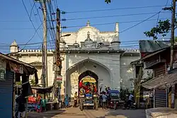
 Main entrance to Dinajpur Rajbari in Dinajpur | |
.svg.png.webp) | |
| Coordinates: 25°38′N 88°39′E / 25.633°N 88.650°E | |
| Country | |
| Division | Rangpur |
| District | Dinajpur |
| Headquarters | Dinajpur |
| Area | |
| • Total | 354.73 km2 (136.96 sq mi) |
| Elevation | 37 m (121 ft) |
| Population (2011) | |
| • Total | 484,597 |
| • Density | 1,400/km2 (3,500/sq mi) |
| Time zone | UTC+6 (BST) |
| Website | dinajpursadar |
Dinajpur Sadar (Bengali: দিনাজপুর সদর) is an upazila of Dinajpur District in the Division of Rangpur, Bangladesh.[1]
Geography
Dinajpur Sadar is located at 25°38′00″N 88°39′00″E / 25.6333°N 88.6500°E. It has 111,779 households and total area 354.73 km2.
Dinajpur Sadar Upazila is bounded by Kaharole and Khansama Upazilas on the north, Chirirbandar Upazila on the east, Kumarganj and Gangarampur CD Blocks in Dakshin Dinajpur district, West Bengal, India, on the south, and Biral Upazila on the west.[2][3][4]
Demographics
According to the 2011 Bangladesh census, Dinajpur Sadar Upazila had 111,779 households and a population of 484,597. 94,188 (19.44%) were under 10 years of age. Dinajpur Sadar had a literacy rate (age 7 and over) of 64.26%, compared to the national average of 51.8%, and a sex ratio of 956 females per 1000 males. 191,329 (39.48%) lived in urban areas.[5] Ethnic population was 6,607 (1.36%), of which Santal were 4,191, Oraon 828 and Barman 641.[6]
As of the 1991 Bangladesh census, Dinajpur Sadar has a population of 357,888. Males constitute 52.08% of the population, and females 47.92%. This Upazila's eighteen up population is 187,016. Dinajpur Sadar has an average literacy rate of 41.1% (7+ years), and the national average of 32.4% literate. Also, Nanabari is at Dinajpur.[7]
Administration
Dinajpur Sadar Upazila is divided into Dinajpur Municipality and ten union parishads: Askorpur, Auliapur, Chealgazi, Fazilpur, Kamalpur, Sankarpur, Shashora, Shekpura, Sundorbon, and Uthrail. The union parishads are subdivided into 211 mauzas and 207 villages.[5]
Dinajpur Municipality is subdivided into 12 wards and 80 mahallas.[5]
Member of Parliament: Iqbalur Rahim.
Education
According to Banglapedia, Dinajpur Government Girls' High School, founded in 1869, is a notable secondary school.[1] Dinajpur Zilla School was established in 1854 during the British reign. It is located at the centre of the Dinajpur town.[8]
There is also a Textile College in the district.[9]
See also
References
- 1 2 Zubayerur Rahman (2012), "Dinajpur Sadar Upazila", in Sirajul Islam and Ahmed A. Jamal (ed.), Banglapedia: National Encyclopedia of Bangladesh (Second ed.), Asiatic Society of Bangladesh
- ↑ "Dinajpur Sadae Upazila". Banglapedia. Retrieved 8 December 2018.
- ↑ "District Census Handbook 2011 Dakshin Dinajpur" (PDF). Map of Dakshin Dinajpur showing CD Blocks on the fourth page. Directorate of Census Operations. Retrieved 8 December 2018.
- ↑ "District Human Development Report". Uttar Dinajpur. Page 14: Map showing locational setting of Uttar Dinajpur district (includes Dakshin Dinajpur district). Department of Planning, Statistics and Programme Implementation, Government of West Bengal. Retrieved 8 December 2018.
- 1 2 3 4 "Bangladesh Population and Housing Census 2011 Zila Report – Dinajpur" (PDF). bbs.gov.bd. Bangladesh Bureau of Statistics.
- ↑ "Community Tables: Dinajpur district" (PDF). bbs.gov.bd. Bangladesh Bureau of Statistics. 2011.
- ↑ "Population Census Wing, BBS". Archived from the original on 2005-03-27. Retrieved November 10, 2006.
- ↑ "Home » Dinajpur Zilla School". www.dinajpurzillaschool.edu.bd.
- ↑ "dsr – TEXTILE INSTITUTE DINAJPUR".
