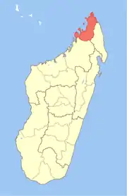
Diana Region | |
|---|---|
Region | |
 Shield | |
 Location in Madagascar | |
| Country | |
| Capital | Antsiranana |
| Government | |
| • Gouvenor | Taciano Rakotomanga |
| Area | |
| • Total | 19,266 km2 (7,439 sq mi) |
| Population (2018)[2] | |
| • Total | 889,736 |
| • Density | 46/km2 (120/sq mi) |
| Time zone | UTC3 (EAT) |
| HDI (2018) | 0.597[3] medium · 2nd of 22 |
Diana is a region in Madagascar at the northern part of the island. It borders the regions of Sava to the southeast and Sofia to the southwest. It covers an area of 19,266 km2, and had a population of 889,736 in 2018.[2] The regional capital is Antsiranana (previously known as Diego Suarez).
Geography
Rivers
The main rivers of the Diana region are:
Protected areas and visitors' attractions
The following national parks, reserves and visitors' attractions are located in Diana:
- Ambodivahibe New Protected Area
- Andrafiamena Andavakoera New Protected Area
- Nosy Antsoha New Protected Area
- Ampasindava New Protected Area
- Galoko Kalobinono New Protected Area
- Oronjia New Protected Area
- Amber Mountain National Park
- Analamerana Reserve
- Ankarana Reserve
- Lokobe National Park
- Manongarivo Reserve
- Tsaratanana National Park
- Nosy Hara National Park
- Nosy Tanikely National Park
- Ambohitr'Antsingy (Montagne des Français) New Protected Area
- Ankarea New Protected Area
- Ankivonjy New Protected Area
- Part of COMATSA Avaratra New Protected Area
- Part of COMATSA Atsimo New Protected Area
- Tsingy Rouge
Administrative divisions

Diana Region is divided into five districts, which are subdivided into 51 communes. The districts are listed below with their 2013 populations:[4]
- Ambanja District - 18 communes; 190,435 inhabitants
- Ambilobe District - 15 communes; 216,145 inhabitants
- Antsiranana I District 1 commune; 115,015 inhabitants; the city of Antsiranana
- Antsiranana II District - 16 communes; 105,416 inhabitants; the rural area surrounding the city
- Nosy Be District 1 commune; 73,010 inhabitants; the island of Nosy Be
Transport
- Seaports in Antsiranana and Nosy Be
- 2 regional airports, Antsiranana Airport and Nosy Be Airport
- 2 local airports in Ambanja and Ambilobe
- The region is crossed by the paved
- Route Nationale 6 (Antsiranana - Ambilobe - Ambanja) and the unpaved
- Route Nationale 5a from Ambilobe to Iharana as well as
- National road 59b (Antsiranana - Ramena)
Economy
Fishery
Antsiranana is an important tuna fishing port. There is also a tuna canning factory. Other important fishery products are shrimp (2.813.291 kg exported in 2002) and sea cucumber.
Agriculture
The main crops are:
- subsistence agriculture: 75.510 ha (67% of the cultivated area): rice, manioc, corn, beans, sweet potato and potato
- cash crops: 21.560 ha (19% of the cultivated area): coffee, pepper, cacao and vanilla
- industrial crops: 15.420 ha (13% of the cultivated area): sugar cane, peanuts and cotton
There are also important productions of essential oils (mainly ylang ylang but also palmarosa, vetyver and basil) on 2465 ha in the regions of Nosy Be and Ambanja.
Mining
Pozzolana, lime, gold, sapphire, graphite, lead, zinc, corundum, amethyst, garnet, zircon, cordierite, quartz, beryl and ilmenite are extracted in the region.
- Ampasindava mine, a rare earth mine.
References
- ↑ [lexpress.mg/20/09/2023/education-une-nouvelle-ecole-aux-normes-dans-la-brousse/ L'Express.mg]
- 1 2 "Troisieme Recensement General de la Population et de L'Habitation (RGPH-3) Resultats Provisoires" (PDF). Institut National de la Statistique Madagascar. Retrieved May 23, 2020.
- ↑ "Sub-national HDI - Area Database - Global Data Lab". hdi.globaldatalab.org. Retrieved 2018-09-13.
- ↑ Institut National de la Statistique, Madagascar.
External links
(in French) Monographie de la Région Diana
