Dermott, Arkansas | |
|---|---|
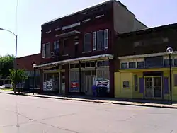
 Downtown Dermott | |
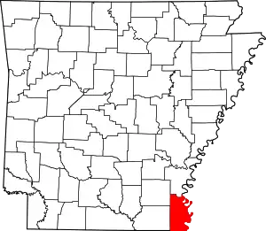
 Location of Dermott in Chicot County, Arkansas. | |
| Coordinates: 33°31′43″N 91°26′16″W / 33.52861°N 91.43778°W | |
| Country | United States |
| State | Arkansas |
| County | Chicot |
| Area | |
| • Total | 3.49 sq mi (9.05 km2) |
| • Land | 3.42 sq mi (8.86 km2) |
| • Water | 0.07 sq mi (0.19 km2) |
| Elevation | 141 ft (43 m) |
| Population (2020) | |
| • Total | 2,021 |
| • Density | 590.76/sq mi (228.08/km2) |
| Time zone | UTC-6 (Central (CST)) |
| • Summer (DST) | UTC-5 (CDT) |
| ZIP code | 71638 |
| Area code | 870 |
| FIPS code | 05-18520 |
| GNIS feature ID | 0057646 |
Dermott is a city in Chicot County, Arkansas, United States. The population was 2,316 at the 2010 census.[2] Dermott was incorporated in 1890.
Dermott was home to the Dermott Crawfish Festival.
Geography
Dermott is located in the northwest corner of Chicot County at 33°31′43″N 91°26′16″W / 33.52861°N 91.43778°W (33.528712, -91.437657).[3] Bayou Bartholomew, a tributary of the Ouachita River, touches the southwest corner of the city. U.S. Route 165 passes southeast of the city center, leading north 9 miles (14 km) to McGehee and south 15 miles (24 km) to Montrose. Arkansas Highway 35 passes through the center of Dermott and leads northwest 23 miles (37 km) to Monticello.
According to the United States Census Bureau, Dermott has a total area of 3.6 square miles (9.4 km2), of which 3.6 square miles (9.2 km2) is land and 0.08 square miles (0.2 km2), or 1.97%, is water.[2]
Climate
The climate in this area is characterized by hot, humid summers and generally mild to cool winters. According to the Köppen Climate Classification system, Dermott has a humid subtropical climate, abbreviated "Cfa" on climate maps.[4]
| Climate data for Dermott, Arkansas (1991–2020 normals, extremes 1963–2020) | |||||||||||||
|---|---|---|---|---|---|---|---|---|---|---|---|---|---|
| Month | Jan | Feb | Mar | Apr | May | Jun | Jul | Aug | Sep | Oct | Nov | Dec | Year |
| Record high °F (°C) | 81 (27) |
85 (29) |
89 (32) |
95 (35) |
99 (37) |
106 (41) |
107 (42) |
107 (42) |
106 (41) |
98 (37) |
88 (31) |
83 (28) |
107 (42) |
| Mean daily maximum °F (°C) | 50.8 (10.4) |
55.4 (13.0) |
64.1 (17.8) |
73.1 (22.8) |
81.6 (27.6) |
88.3 (31.3) |
91.0 (32.8) |
91.0 (32.8) |
86.2 (30.1) |
76.1 (24.5) |
63.2 (17.3) |
53.3 (11.8) |
72.8 (22.7) |
| Daily mean °F (°C) | 42.4 (5.8) |
46.3 (7.9) |
54.6 (12.6) |
63.1 (17.3) |
71.7 (22.1) |
78.8 (26.0) |
81.4 (27.4) |
80.5 (26.9) |
74.9 (23.8) |
64.2 (17.9) |
53.0 (11.7) |
44.9 (7.2) |
63.0 (17.2) |
| Mean daily minimum °F (°C) | 34.0 (1.1) |
37.1 (2.8) |
45.0 (7.2) |
53.2 (11.8) |
61.8 (16.6) |
69.3 (20.7) |
71.8 (22.1) |
70.0 (21.1) |
63.7 (17.6) |
52.3 (11.3) |
42.7 (5.9) |
36.6 (2.6) |
53.1 (11.7) |
| Record low °F (°C) | 1 (−17) |
9 (−13) |
15 (−9) |
27 (−3) |
36 (2) |
43 (6) |
52 (11) |
51 (11) |
32 (0) |
25 (−4) |
16 (−9) |
−3 (−19) |
−3 (−19) |
| Average precipitation inches (mm) | 5.52 (140) |
5.40 (137) |
5.45 (138) |
6.06 (154) |
4.97 (126) |
4.00 (102) |
3.85 (98) |
3.01 (76) |
3.14 (80) |
4.42 (112) |
4.46 (113) |
5.99 (152) |
56.27 (1,428) |
| Average snowfall inches (cm) | 0.5 (1.3) |
0.5 (1.3) |
0.3 (0.76) |
0.0 (0.0) |
0.0 (0.0) |
0.0 (0.0) |
0.0 (0.0) |
0.0 (0.0) |
0.0 (0.0) |
0.0 (0.0) |
0.0 (0.0) |
0.0 (0.0) |
1.3 (3.36) |
| Average precipitation days (≥ 0.01 in) | 9.7 | 8.9 | 9.6 | 8.3 | 9.1 | 7.4 | 7.2 | 6.6 | 5.5 | 6.1 | 7.5 | 9.3 | 95.2 |
| Average snowy days (≥ 0.1 in) | 0.2 | 0.3 | 0.1 | 0.0 | 0.0 | 0.0 | 0.0 | 0.0 | 0.0 | 0.0 | 0.0 | 0.0 | 0.6 |
| Source: NOAA[5][6] | |||||||||||||
Demographics
| Census | Pop. | Note | %± |
|---|---|---|---|
| 1900 | 467 | — | |
| 1910 | 1,662 | 255.9% | |
| 1920 | 2,330 | 40.2% | |
| 1930 | 2,942 | 26.3% | |
| 1940 | 3,083 | 4.8% | |
| 1950 | 3,601 | 16.8% | |
| 1960 | 3,665 | 1.8% | |
| 1970 | 4,250 | 16.0% | |
| 1980 | 4,731 | 11.3% | |
| 1990 | 4,715 | −0.3% | |
| 2000 | 3,292 | −30.2% | |
| 2010 | 2,316 | −29.6% | |
| 2020 | 2,021 | −12.7% | |
| U.S. Decennial Census[7] 2014 Estimate[8] | |||
2020 census
| Race | Num. | Perc. |
|---|---|---|
| White | 349 | 17.27% |
| Black or African American | 1,571 | 77.73% |
| Native American | 6 | 0.3% |
| Asian | 10 | 0.49% |
| Other/Mixed | 58 | 2.87% |
| Hispanic or Latino | 27 | 1.34% |
As of the 2020 United States Census, there were 2,021 people, 810 households, and 547 families residing in the city.
2010 census
As of the 2010 United States Census, there were 2,889 people living in the city. 77.8% were African American, 20.2% White, 0.1% Native American, 0.7% Asian, 0.1% from some other race and 1.0% from two or more races. 1.0% were Hispanic or Latino of any race.
2000 census
As of the census[10] of 2000, there were 4865 people, 1,216 households, and 824 families living in the city. The population density was 1,165.3 inhabitants per square mile (449.9/km2). There were 1,404 housing units at an average density of 497.0 per square mile (191.9/km2). The racial makeup of the city was 25.24% White, 73.27% Black or African American, 0.15% Native American, 0.30% Asian, 0.06% from other races, and 0.97% from two or more races. 0.76% of the population were Hispanic or Latino of any race.
There were 1,216 households, out of which 29.9% had children under the age of 18 living with them, 36.2% were married couples living together, 27.7% had a female householder with no husband present, and 32.2% were non-families. 28.8% of all households were made up of individuals, and 14.3% had someone living alone who was 65 years of age or older. The average household size was 2.59 and the average family size was 3.21.
In the city, the population was spread out, with 29.0% under the age of 18, 8.7% from 18 to 24, 24.1% from 25 to 44, 22.5% from 45 to 64, and 15.7% who were 65 years of age or older. The median age was 36 years. For every 100 females, there were 81.6 males. For every 100 females age 18 and over, there were 78.6 males.
The median income for a household in the city was $17,857, and the median income for a family was $22,214. Males had a median income of $21,134 versus $17,318 for females. The per capita income for the city was $9,998. About 25.9% of families and 32.5% of the population were below the poverty line, including 43.0% of those under age 18 and 22.4% of those age 65 or over.
Arts and culture
Annual cultural events
The Dermott Crawfish Festival was one of the oldest festivals in Arkansas. The festival was held annually on the third weekend in May and was sponsored by the Dermott Chamber of Commerce. From 1996 through 2006, the Texas artist Larry D. Alexander, who is a native of Dermott, usually ended his Arkansas Schools Tours with a two-day art exhibit and print signing there at the festival. The Crawfish Festival was typically a food and music festival. In 2006, a car/truck/rim show was added to the festival. The Crawfish Festival also hosted a carnival during the entire week. Other events included in the festival were the annual Rotary Club pancake breakfast, bingo, a horseshoe pitching contest, an antique tractor show, and multiple cash drawings.
In 2012 the Dermott Chamber of Commerce cancelled the Dermott Crawfish Festival and no longer sponsors this event. Community leaders and African American Business owners formed a committee to continue the Spirit of the community and now host Dermott Community Festival.
Education
Dermott School District operates public schools in the community. Dermott High School's colors are orange and black. They are the home of the Mighty Rams or Rams. The boys basketball teams won state basketball championships in 1986, 1989, 1991 and 1994. For 2012–14, the Dermott Rams belong to the 2A Region 7 West conference. For its first championship in 1986, Dermott went undefeated (35-0) and won the overall state championship, coached by Willie Parker and Leroy Kennedy. The Rams have been in the top in the 2-AA class but have not made a playoff run since 2000, when they made it to the championship game. Dermott has four state championships and numerous regional and tournament championships.
The Southeast Arkansas Public Library operates the Dermott Branch Library.[11]
History
During World War II, Dermott was the site of one of several camps holding German prisoners of war.[12]
Notable people

- Thane Read, global peace activist
- Larry D. Alexander, visual artist/writer[13]
- Robert L. Hill, founder of the Progressive Farmers and Household Union of America
- Art Kaufman, defensive coordinator, California Golden Bears football
- Samuel L. Kountz, kidney transplant surgeon
- Zilner Randolph, jazz musician
References
- ↑ "2020 U.S. Gazetteer Files". United States Census Bureau. Retrieved October 29, 2021.
- 1 2 "Geographic Identifiers: 2010 Demographic Profile Data (G001): Dermott city, Arkansas (revision of 12-20-2011)". U.S. Census Bureau, American Factfinder. Archived from the original on February 12, 2020. Retrieved June 13, 2014.
- ↑ "US Gazetteer files: 2010, 2000, and 1990". United States Census Bureau. February 12, 2011. Retrieved April 23, 2011.
- ↑ Climate Summary for Dermott, Arkansas
- ↑ "NOWData - NOAA Online Weather Data". National Oceanic and Atmospheric Administration. Retrieved October 31, 2023.
- ↑ "Summary of Monthly Normals 1991-2020". National Oceanic and Atmospheric Administration. Retrieved October 31, 2023.
- ↑ "Census of Population and Housing". Census.gov. Retrieved June 4, 2015.
- ↑ "Annual Estimates of the Resident Population for Incorporated Places: April 1, 2010 to July 1, 2014". Archived from the original on May 22, 2015. Retrieved June 4, 2015.
- ↑ "Explore Census Data". data.census.gov. Retrieved December 7, 2021.
- ↑ "U.S. Census website". United States Census Bureau. Retrieved January 31, 2008.
- ↑ "Home". Southeast Arkansas Public Library. Retrieved May 18, 2023. - Check the hours and locations tab: "117 S. Freeman Dermott, AR 71638"
- ↑ "World War II Prisoner of War Camps". Encyclopedia of Arkansas. July 28, 2023. Retrieved November 13, 2023.
- ↑ Encyclopedia of Arkansas - Larry Dell Alexander
External links
- Dermott Crawfish Festival
- Encyclopedia of Arkansas History & Culture entry: Dermott (Chicot County)
- Dermott Area Chamber of Commerce
- Dermott School District
