Clatskanie, Oregon | |
|---|---|
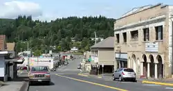
 Downtown Clatskanie | |
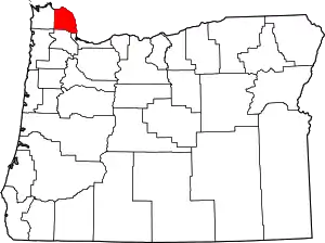
 Location in Oregon | |
| Coordinates: 46°06′17″N 123°12′16″W / 46.10472°N 123.20444°W | |
| Country | United States |
| State | Oregon |
| County | Columbia |
| Incorporated | 1891 |
| Government | |
| • Mayor | Bob Brajcich |
| Area | |
| • Total | 1.30 sq mi (3.36 km2) |
| • Land | 1.30 sq mi (3.36 km2) |
| • Water | 0.00 sq mi (0.00 km2) |
| Elevation | 23 ft (7 m) |
| Population | |
| • Total | 1,716 |
| • Density | 1,324.07/sq mi (511.32/km2) |
| Time zone | UTC-8 (Pacific) |
| • Summer (DST) | UTC-7 (Pacific) |
| ZIP code | 97016 |
| Area code(s) | 503 and 971 |
| FIPS code | 41-13750[4] |
| GNIS feature ID | 2409472[2] |
| Website | www.cityofclatskanie.com |
Clatskanie (/ˈklætskɪnaɪ/) is a city in Columbia County, Oregon, United States. It was named for the Tlatskanai Native American tribe, and the Clatskanie River which flows through the town and empties into the Columbia River about four miles to the north. The population was 1,737 at the 2010 Census.
History
The town was originally called Bryantville after the large family who were among the first filers of Donation Land Claims in the area in 1852-53. However, the first postmaster, Enoch Conyers, who was married to one of the Bryant daughters, changed the name to Clatskanie after the Tlatskanai Native American tribe.
According to the Clatsop County pioneer Silas B. Smith, Tlatskanai was a point in the Nehalem River that was reached from the Columbia River by way of the Youngs River or by way of the Clatskanie River. The native inhabitants, who were not in the habit of naming streams, did not use the word Tlatskanai for the streams they would follow in order to get to that point, but the white men who settled here later did apply the name to the streams.[5]
Many of Clatskanie's inhabitants are of Nordic heritage, specifically Finnish, Swedish, and Norwegian.[6]
Geography
According to the United States Census Bureau, the city has a total area of 1.19 square miles (3.08 km2), all of it land.[7]
Climate
According to the Köppen Climate Classification system, Clatskanie has a warm-summer Mediterranean climate, abbreviated "Csb" on climate maps.[8]
| Climate data for Clatskanie | |||||||||||||
|---|---|---|---|---|---|---|---|---|---|---|---|---|---|
| Month | Jan | Feb | Mar | Apr | May | Jun | Jul | Aug | Sep | Oct | Nov | Dec | Year |
| Record high °F (°C) | 61 (16) |
72 (22) |
78 (26) |
86 (30) |
94 (34) |
99 (37) |
103 (39) |
103 (39) |
100 (38) |
88 (31) |
72 (22) |
64 (18) |
103 (39) |
| Mean daily maximum °F (°C) | 44.3 (6.8) |
49.2 (9.6) |
53.6 (12.0) |
58.5 (14.7) |
64.4 (18.0) |
68.5 (20.3) |
73.6 (23.1) |
74.1 (23.4) |
71.1 (21.7) |
61 (16) |
50.5 (10.3) |
44.9 (7.2) |
59.5 (15.3) |
| Mean daily minimum °F (°C) | 33.2 (0.7) |
34.4 (1.3) |
36.5 (2.5) |
39.4 (4.1) |
44.3 (6.8) |
49.2 (9.6) |
52.7 (11.5) |
53.1 (11.7) |
49.3 (9.6) |
43.3 (6.3) |
37.6 (3.1) |
34.4 (1.3) |
42.3 (5.7) |
| Record low °F (°C) | 4 (−16) |
1 (−17) |
20 (−7) |
25 (−4) |
28 (−2) |
35 (2) |
37 (3) |
40 (4) |
30 (−1) |
17 (−8) |
8 (−13) |
1 (−17) |
1 (−17) |
| Average precipitation inches (mm) | 8.88 (226) |
6.65 (169) |
6.25 (159) |
3.88 (99) |
2.55 (65) |
1.83 (46) |
0.69 (18) |
0.99 (25) |
2.06 (52) |
4.5 (110) |
8.59 (218) |
9.54 (242) |
56.41 (1,433) |
| Average snowfall inches (cm) | 4.4 (11) |
1.5 (3.8) |
1 (2.5) |
0 (0) |
0 (0) |
0 (0) |
0 (0) |
0 (0) |
0 (0) |
0 (0) |
0.3 (0.76) |
1.8 (4.6) |
9.1 (23) |
| Average precipitation days (≥ 0.01 inch) | 21 | 18 | 20 | 17 | 14 | 11 | 6 | 6 | 9 | 15 | 20 | 22 | 179 |
| Source: [9] | |||||||||||||
Demographics
| Census | Pop. | Note | %± |
|---|---|---|---|
| 1890 | 212 | — | |
| 1900 | 311 | 46.7% | |
| 1910 | 747 | 140.2% | |
| 1920 | 1,171 | 56.8% | |
| 1930 | 739 | −36.9% | |
| 1940 | 708 | −4.2% | |
| 1950 | 901 | 27.3% | |
| 1960 | 797 | −11.5% | |
| 1970 | 1,286 | 61.4% | |
| 1980 | 1,648 | 28.1% | |
| 1990 | 1,629 | −1.2% | |
| 2000 | 1,528 | −6.2% | |
| 2010 | 1,737 | 13.7% | |
| 2020 | 1,716 | −1.2% | |
| U.S. Decennial Census[10][3] | |||

2010 census
As of the census of 2010, there were 1,737 people, 729 households, and 469 families living in the city. The population density was 1,459.7 inhabitants per square mile (563.6/km2). There were 806 housing units at an average density of 677.3 per square mile (261.5/km2). The racial makeup of the city was 92.9% White, 0.4% African American, 2.0% Native American, 0.5% Asian, 0.1% Pacific Islander, 0.9% from other races, and 3.3% from two or more races. Hispanic or Latino of any race were 3.7% of the population.[4]
There were 729 households, of which 32.4% had children under the age of 18 living with them, 46.8% were married couples living together, 12.1% had a female householder with no husband present, 5.5% had a male householder with no wife present, and 35.7% were non-families. 30.9% of all households were made up of individuals, and 16.3% had someone living alone who was 65 years of age or older. The average household size was 2.36 and the average family size was 2.91.[4]
The median age in the city was 38.9 years. 24.8% of residents were under the age of 18; 8.6% were between the ages of 18 and 24; 22.6% were from 25 to 44; 27.8% were from 45 to 64; and 16.1% were 65 years of age or older. The gender makeup of the city was 47.8% male and 52.2% female.[4]
2000 census
As of the census of 2000, there were 1,528 people, 608 households, and 406 families living in the city. The population density was 1,274.1 inhabitants per square mile (491.9/km2). There were 659 housing units at an average density of 549.5 per square mile (212.2/km2). The racial makeup of the city was 93.91% White, 0.07% African American, 1.24% Native American, 0.65% Asian, 0.26% Pacific Islander, 1.05% from other races, and 2.81% from two or more races. Hispanic or Latino of any race were 3.34% of the population. 22.6% were of German, 10.3% Norwegian, 9.4% Finnish, 9.1% Irish, 8.2% English and 6.8% American ancestry according to Census 2000. 94.0% spoke English, 4.1% Spanish and 1.6% Finnish as their first language.[4]
There were 608 households, out of which 35.0% had children under the age of 18 living with them, 51.6% were married couples living together, 12.7% had a female householder with no husband present, and 33.1% were non-families. 27.8% of all households were made up of individuals, and 15.3% had someone living alone who was 65 years of age or older. The average household size was 2.47 and the average family size was 3.07.[4]
In the city, the population was spread out, with 29.6% under the age of 18, 7.3% from 18 to 24, 26.0% from 25 to 44, 21.0% from 45 to 64, and 16.0% who were 65 years of age or older. The median age was 36 years. For every 100 females, there were 90.5 males. For every 100 females age 18 and over, there were 81.3 males.[4]
The median income for a household in the city was $35,833, and the median income for a family was $48,056. Males had a median income of $41,550 versus $24,286 for females. The per capita income for the city was $16,717. About 11.1% of families and 11.5% of the population were below the poverty line, including 11.4% of those under age 18 and 12.1% of those age 65 or over.[4]
Education
Clatskanie is served by the two public schools of Clatskanie School District, namely the combined Clatskanie Middle/High School, and Clatskanie Elementary School, as well as Piercing Arrow Private School.
Politics
| Year | DEM | GOP | Others |
|---|---|---|---|
| 2020 | 39.5% 367 | 57.2% 531 | 3.3% 31 |
| 2016 | 34.3% 265 | 52.8% 408 | 12.9% 100 |
| 2012 | 46.3% 348 | 50.0% 376 | 3.7% 28 |
| 2008 | 51.3% 382 | 45.1% 336 | 3.6% 27 |
| 2004 | 48.4% 382 | 50.5% 399 | 1.1% 9 |
Clatskanie has generally voted Republican in recent years in presidential elections, with the notable exception being Barack Obama in 2008.
Notable people
- Raymond Carver (1938–1988), short story writer and poet[12]
- Cole Escola (1986–), comedian and actor[13]
- Harvey Karman (1924–2008), psychologist and abortion rights activist[14]
- Merlin F. Schneider (1901-1970), Brigadier General, USMC, recipient of the Navy Cross.[15]
See also
- Thomas J. Flippin House
- The Chief (Oregon newspaper), a paper long based in Clatskanie, founded in 1891
References
- ↑ "ArcGIS REST Services Directory". United States Census Bureau. Retrieved October 12, 2022.
- 1 2 U.S. Geological Survey Geographic Names Information System: Clatskanie, Oregon
- 1 2 "Census Population API". United States Census Bureau. Retrieved October 12, 2022.
- 1 2 3 4 5 6 7 8 "U.S. Census website". United States Census Bureau. Retrieved December 21, 2012.
- ↑ "Oregon Indian Tribes". July 9, 2011.
- ↑ "The City of Clatskanie". Clatskanie School District.
- ↑ "US Gazetteer files 2010". United States Census Bureau. Archived from the original on January 25, 2012. Retrieved December 21, 2012.
- ↑ "Clatskanie, Oregon". Weatherbase. CantyMedia. 2015. Retrieved October 1, 2015.
- ↑ "Clatskanie, Oregon (351643)". Western Regional Climate Center. Retrieved November 16, 2015.
- ↑ "Census of Population and Housing". Census.gov. Retrieved June 4, 2015.
- ↑ "Past Election Results". Columbia County, Oregon. Retrieved February 7, 2021.
- ↑ "Ray Carver Writing Festival". Archived from the original on May 9, 2013. Retrieved February 12, 2013.
- ↑ Vincentelli, Elisabeth (July 6, 2017). "He's Got a Good Wig on His Shoulders: Meet Cole Escola," The New York Times. Retrieved September 18, 2017.
- ↑ Woo, Elaine (May 19, 2008). "Inventor, activist Harvey Karman, 84". Los Angeles Times. Archived from the original on November 29, 2014. Retrieved September 19, 2017.
- ↑ "Marine Corps Chevron, Volume 4, Number 22, 9 June 1945". historicperiodicals.princeton.edu. Marine Corps Chevron - Princeton University Library. Retrieved January 7, 2017.
External links
![]() Media related to Clatskanie, Oregon at Wikimedia Commons
Media related to Clatskanie, Oregon at Wikimedia Commons
