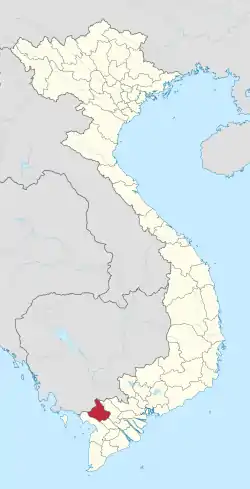
An Giang province
Tỉnh An Giang | |
|---|---|
From left to right, from top to bottom: Bà Chúa Xứ Temple of Sam Mountain, Maitreya Buddha statue sitting on Cấm Mountain in Tịnh Biên, Temple of late President Tôn Đức Thắng, Mausoleum of Thoại Ngọc Hầu, Tomb of Ba Chúc | |
 Seal | |
 Location of An Giang within Vietnam | |
| Coordinates: 10°30′N 105°10′E / 10.500°N 105.167°E | |
| Country | |
| Region | Mekong Delta |
| Capital of Province | Long Xuyên City |
| Government | |
| • People's Council Chair | Lê Văn Nưng |
| • People's Committee Chair | Nguyễn Thanh Bình |
| Area | |
| • Total | 3,536.83 km2 (1,365.58 sq mi) |
| Population (2021) | |
| • Total | 1,909,507 |
| • Density | 540/km2 (1,400/sq mi) |
| Demographics | |
| • Ethnicities | Vietnamese, Khmer, Hoa, Chăm |
| Time zone | UTC+7 (ICT) |
| Area codes | 296 |
| ISO 3166 code | VN-44 |
| Website | www |
An Giang (Vietnamese: [ʔaːn˧˧ jaːŋ˧˧] ⓘ) is a province of Vietnam. It is located in the Mekong Delta, in the southwestern part of the country.
Geography

An Giang occupies a position in the upper reaches of the Mekong Delta. The Hậu Giang and Tiền Giang branches of the Mekong River are the dominant geographical features of the province. With the exception of the west, most of An Giang is fairly flat and is criss-crossed by many canals and small rivers. This terrain has led to An Giang being a significant agricultural center, producing significant quantities of rice.
The Cấm Mountains, also known as the Thất Sơn range or the "Seven Mountains", are located in the western Tịnh Biên District. Followers of the Bửu Sơn Kỳ Hương tradition, founded in An Giang in 1849, refer to these mountains as Bửu Sơn, "Precious Mountains".
Administrative divisions
An Giang is subdivided into 11 district-level sub-divisions:
- Districts:
- An Phú: 3 towns and 11 rural communes
- Châu Phú: 2 town and 11 rural communes
- Châu Thành: 2 town and 11 rural communes
- Chợ Mới: 3 towns and 15 rural communes
- Phú Tân: 2 towns and 16 rural communes
- Thoại Sơn: 3 towns and 14 rural communes
- Tri Tôn: 3 towns and 12 rural communes
- District-level town:
- Provincial cities:
- Châu Đốc: 5 wards and 2 rural communes
- Long Xuyên: 11 wards and 2 rural communes (capital of province)
- They are further subdivided into 18 commune-level towns (or townlets), 110 communes, and 28 wards (156 in total).
Demographics
An Giang first became a province in 1832, having been settled by the Vietnamese migrants moving southwards in search of new land. It is believed that An Giang was once an important center of the 1st millennium Óc Eo culture, presumably owing to its position on the river. Traditionally, An Giang has been known for its silk industry.
An Giang is home to a substantial number of people from Vietnam's ethnic minorities. Due to the province's proximity to Cambodia, the Khmer Krom are the largest non-Vietnamese group of the province. Other groups, such as the Chams and ethnic Chinese (Hoa), are also found in An Giang.
As of 2020, An Giang Province covers an area of 3,536.83 square kilometers with a population of 1,904,532 people, resulting in a population density of 539 people per square kilometer.[1]
The province is home to 24,011 households of ethnic minorities, comprising 114,632 people, accounting for 5.17% of the total provincial population.[2]
Notable people
- Tôn Đức Thắng, prominent Communist and former President of the Democratic Republic of Vietnam; later became the first President of the Socialist Republic of Vietnam (Long Xuyên).
- Nguyễn Ngọc Thơ, vice-president of the Republic of Vietnam before April 30, 1975 (Long Xuyên).
- Chau Sen Cocsal Chhum, Khmer Krom and Prime Minister of Cambodia in 1962.
- Vương Trung Hiếu, writer (Thoại Sơn).
- Trịnh Bửu Hoài, writer (Châu Đốc).
- Hoàng Hiệp, musician (Chợ Mới).
- Võ Tòng Xuân, academic, agronomist and former rector of An Giang University (Tri Tôn).
- Huỳnh Phú Sổ, founder of the Hòa Hảo sect of Buddhism (Phú Tân).
- Thoại Ngọc Hầu, general of Nguyễn dynasty (Chợ Mới).
- Đoàn Minh Huyên, founder of the Bửu Sơn Kỳ Hương tradition.
- Vũ Cát Tường, singer.
See also
References
- ↑ "Statistical Yearbook 2021 (57 - AN GIANG PROVINCE STATISTICAL OFFICE/ Population and area of An Giang Province as of December 31, 2020, page 397)" (PDF). General Statistics Office of Vietnam. May 5, 2021.
- ↑ "Population, Area, and Population Density by Province - General Statistics Office - 2016".


